Summer or sweaters? Wild weather shift on tap for Canada this week

This week will see a major pattern shift across Canada that could bring summer weather to some and sweater weather to others.
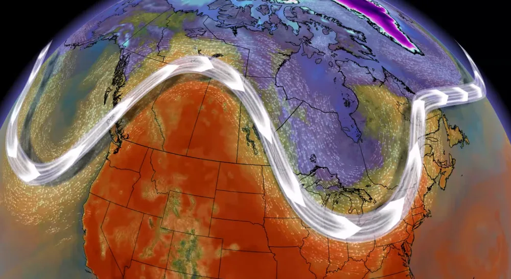
An active jet stream will sweep across Canada as we end August and begin September, bringing a stark contrast in conditions between the eastern and western halves of the country. Depending on where you are, you could enjoy summer weather or sweater weather by the middle of this week.
DON'T MISS: Why extreme heat is one of the world’s deadliest weather disasters
This weekend saw a trough slide over Western Canada while a ridge was built over the eastern half of the country.
The western trough brought a brief reprieve from the hot temperatures that have bathed the region in recent days. Meanwhile, conditions will grow warm and humid again across Ontario, Quebec, and the Atlantic provinces heading into early next week.
Don’t get used to it, though, because things will change in a hurry.
A recurving typhoon in the western Pacific will jumble up the jet stream by the middle of this week, setting up a stark east-west contrast in conditions.

An amplified jet stream will produce a spell of active weather across Canada to round out August and begin September. This wavy jet stream will allow a significant ridge to build over the West while a trough dips down over the East.
Folks out west can expect a return to summertime weather as we begin meteorological fall.
Sinking air beneath the ridge will combine with southerly winds to keep conditions toasty for days on end across parts of British Columbia, Alberta, and Saskatchewan. We could see some 30-degree high temperatures in spots at the height of the heat.

MUST SEE: The top waterproof backpacks for students of all ages
Back east, a trough will bring a taste of fall-like weather to Ontario and Quebec by the middle of this week.
It’s still too early to say how cool things could get, but cottage country might see temperatures cool enough that you may have to dig out a sweater to get through the nighttime and morning hours. Northern portions of the provinces could feel some daytime highs only reaching the mid- to upper-teens.

While the coolest air will remain in central and northern sections of Ontario and Quebec, crisp nights and cooler-than-seasonal daytime highs will still bring a tease of fall to southern portions of each province.
Check back frequently heading into this week for details as we get closer to this pattern flip.
Wavy jet streams don’t stop at stark temperature contrasts -- they’re also a prime track for storms. We could see rainy conditions accompanying those cooler temperatures in Ontario and Quebec.

This pattern won’t stick around for long. Forecasters don’t see any blocking in the upper levels this week, which will put a short shelf life on this temperature flip.
Expect warmer weather to build back in across parts of Eastern Canada by late week, with cooler air and wet weather returning to parts of B.C. at the same time.
Stay tuned to The Weather Network as we watch this active pattern across Canada.