
Stark weather divide between warmth and heavy snow in Alberta Tuesday

Alberta will see an impressive weather divide across the province on Tuesday, with warmth in southern sections and heavy snow and chilly temperatures in the north
As spring gradually makes its way through the Prairies, a burst of warmth will finally spread across parts of the region this week.
In Alberta, a sharp north-south temperature divide will be evident however, as some communities in the southern portion of the province hit their first 20°C temperatures of the year, while northern and central communities deal with heavy snow and powerful winds.
DON’T MISS: Allergy season is coming. Get ahead of it with these must-haves

The vast temperature divide is due to a ridge of high pressure pushing warmth up toward much of the southern portions of the Prairies, while a low-pressure system will bring heavy snow into the north, specifically around the Rockies.
SEE ALSO: Warmth springs to life across Canada, but one province misses out
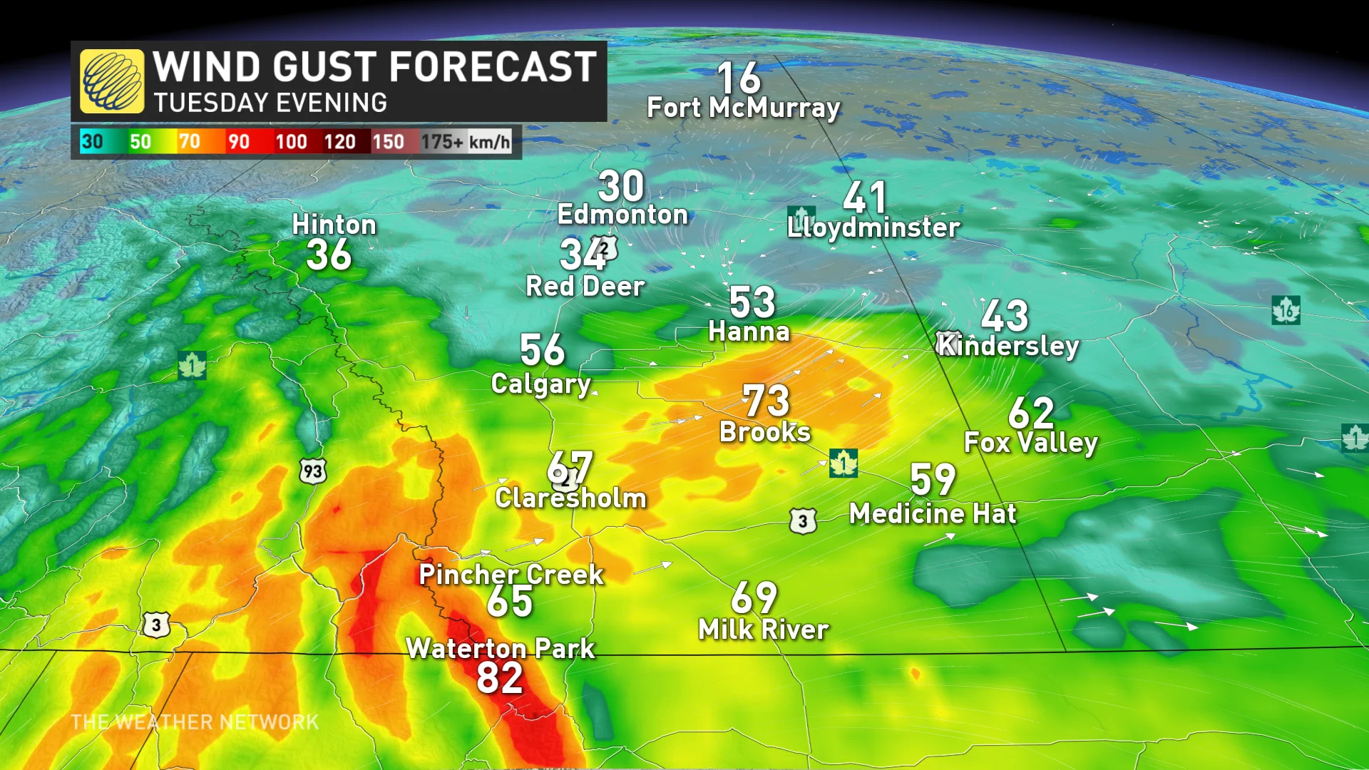
In the south, the cities of Lethbridge and Medicine Hat will see 15°C and 16°C daytime highs on Tuesday, respectively. High winds can be expected throughout the day on Tuesday as well, with widespread westerly gusts of 50-80 km/h in much of the south before weakening on Wednesday. Gusts as high as 100 km/h prompted wind warnings in and around Medicine Hat.
"Damage to buildings, such as to roof shingles and windows, may occur," says Environment and Climate Change Canada (ECCC) in the warning. "Be prepared to adjust your driving with changing road conditions due to high winds."
In the north, ECCC has also issued a snowfall warning from Jasper to Banff.
The snowfall will continue throughout the day Tuesday and taper off to flurries by Wednesday morning. Areas around Banff could see between 15-20 cm of snow and areas around Jasper could see between 20-30 cm.

From Edmonton eastward into northern Saskatchewan, the rain will change to snow through Tuesday afternoon and evening as colder air filters in behind the low. Edmonton could see a few centimetres of snow, while Calgary has the potential to see a trace of snow.
"Rapidly accumulating snow will make travel difficult. Prepare for quickly changing and deteriorating travel conditions," ECCC says in the warning.
This is a classic spring setup as snow is not unusual for Alberta in April, however, the warm temperatures in other parts of the province will make many wonder when they will finally see spring arrive. By Wednesday however, southern Alberta will see a drop in temperatures, with highs in the mid-single digits.
Looking ahead, temperatures will be cooler towards the end of the week for much of the province as well.
Stay tuned to The Weather Network for the latest forecast updates on the Prairies.