Spring storm to unleash icy dangers across Ontario this weekend
Two rounds of significant, widespread freezing rain will increase travel dangers and power outage risks across the province over the weekend
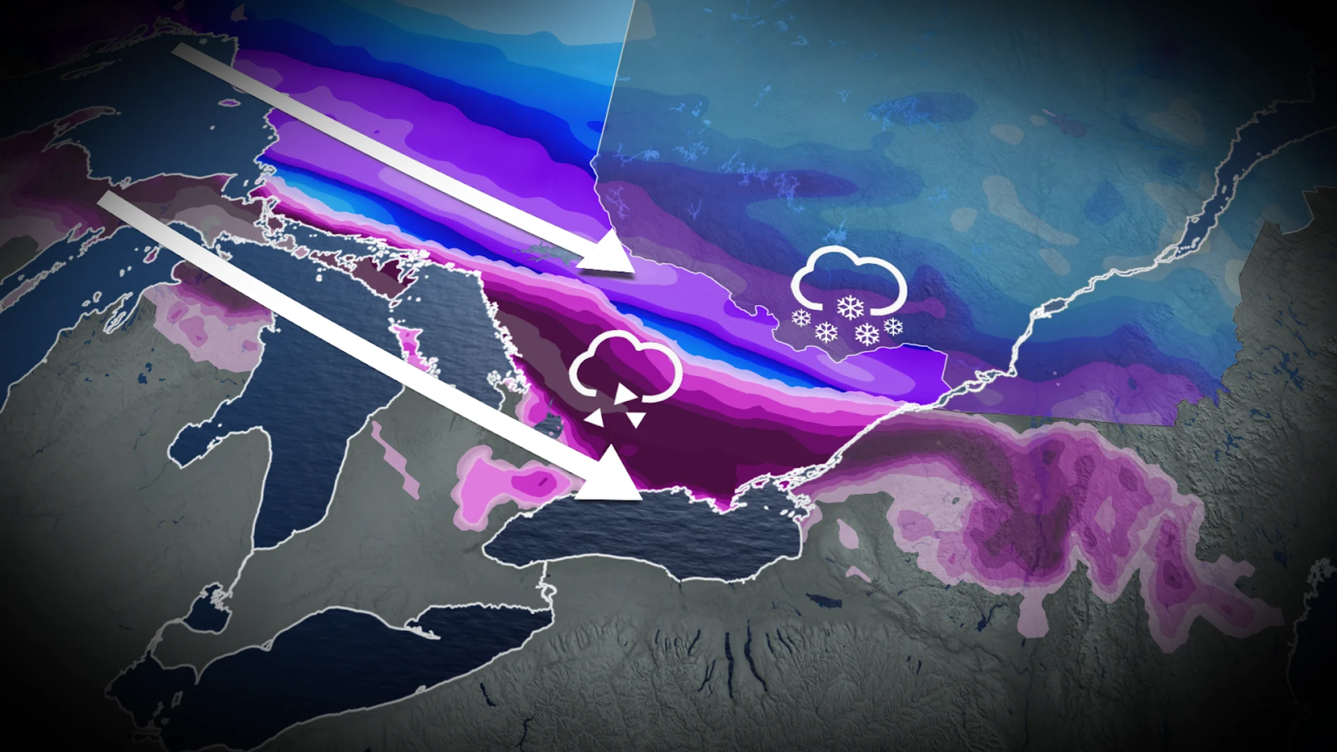
A long-duration ice storm is building up for the weekend across Ontario as sharply contrasting air masses collide over the province, leading to a prime setup for nasty weather.
The boundary between the two air masses will feature significant freezing rain, while south of the boundary will feature soggy rains, and north of the boundary will feature a hefty dose of spring snow.
Visit our Complete Guide to Spring 2025 for an in-depth look at the Spring Forecast, tips to plan for it and much more!
Significant ice buildup will likely lead to some major impacts as roadways become dangerously slippery and power lines become bogged down by the heavy ice. Folks should expect significant impacts to travel over the weekend, as well as prepare for localized power outages.

The ice, rain, and snow will come in two rounds over the weekend, lasting into the work week. Round one will begin Friday evening and last into Saturday, bringing prolonged freezing rain to the province. Round two will begin on Sunday as a new low pushes northeast into Quebec.
SEE ALSO: What weather can Canadian voters expect on April 28? A historical look
The storm setups could change, however, closer to the event due to the shifting nature of the boundary.
Be sure to check highway conditions and local weather alerts before heading out if necessary.
GTA and Hamilton see a changeable mix-up in both rounds
Folks across the Greater Toronto Area (GTA) and Hamilton will likely see this storm kick off with a round of freezing rain on Friday night but will see the icy conditions change to rain by Saturday.

This pattern will continue over Sunday and Monday, with the days starting off with rounds of freezing rain before daytime temperatures take over, transitioning the icy weather back into rain. The lakeshores will help to moderate the ice a bit, so folks closer to the lakes are less likely to see much freezing rain.
On the other hand, those north of the GTA, along the escarpment, and around Oak Ridges Moraine are at a higher risk of seeing prolonged freezing rain. 5-10 hours of icy weather is in store, leading to 2-5 mm of ice accretion.
South of the GTA, toward Windsor, will escape the icy weather but be in for a rainy weekend.
DON'T MISS: Sweet or sticky? How weather can make or break maple syrup season
Impactful ice, snowstorm bears down on eastern Ontario
Round one of this stormy system will start in eastern Ontario on Friday evening with 10-15+ hours of freezing rain.

Folks will get a brief break from the icy mess overnight Saturday, but another round of freezing rain and ice pellets is forecast to move back in by Sunday morning, this time lasting into Monday.
Up to 20-30 mm of ice accretion is forecast across cottage country and into Algonquin, Bancroft, and Kingston. Here, we are most likely to see the biggest impacts on travel and power.
Meanwhile, Ottawa will be sitting north of the icy boundary, meaning the city will be in for a snowstorm with this event. 10-20+ cm of late-March snow is forecast to fall beginning Friday evening. The snow will shift into freezing rain on Sunday as the second low meanders northeast into southern Quebec, giving the fresh snow an icy shell that will make shovelling even more difficult.

Northeastern Ontario will have a similar fate, with a swath of 10-20+ cm snow extending across Lake Superior's north shore and into North Bay.
The Superior and Georgian Bay lakeshores will see a persistent mix of freezing rain and ice pellets Friday night and into Saturday, but will transition into rain for round two on Sunday and Monday.
Stay with The Weather Network for more forecast information and updates on your weather across Ontario.