APRIL: Sustained warmth in jeopardy for parts of Canada

Record highs and lows have marked spring 2019 thus far.
Spring is living up to its reputation of being a tumultuous season. Before we look ahead to the month of April, here is a quick recap of March 2019 – a month of extremes and contrasts.
Visit our Complete Guide to Spring 2019 for an in depth look at the Spring Forecast, tips to plan for it and much more
HISTORIC HIGHS AND LOWS
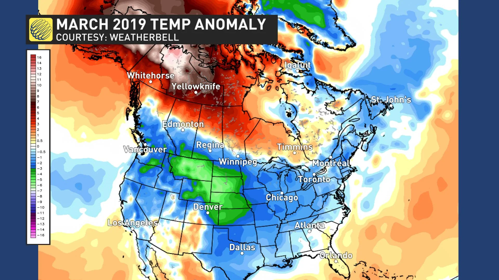
March was a historic month across most of northern Canada with several places, including Yellowknife, recording their warmest March on record. Inuvik, NWT, was a whopping 14.4 ºC warmer than normal for the month. The average high temperature during March in Whitehorse, Yukon (+4.7 ºC) was warmer than the average high recorded in Toronto (+3.1 ºC).
Meanwhile, temperatures were colder than normal across much of southern Canada. The map below shows temperature anomalies for March 2019 with the various shades of blue and green highlighting colder than normal temperatures, while the various shades of orange, red, brown etc. highlighting warmer than normal temperatures.
SEE ALSO: Dire future forecast for Great Lakes
However, the final numbers for March across southern Canada were primarily driven by the extreme cold that occurred during the beginning of the month. The map below shows temperature anomalies for the first 10 days of March.
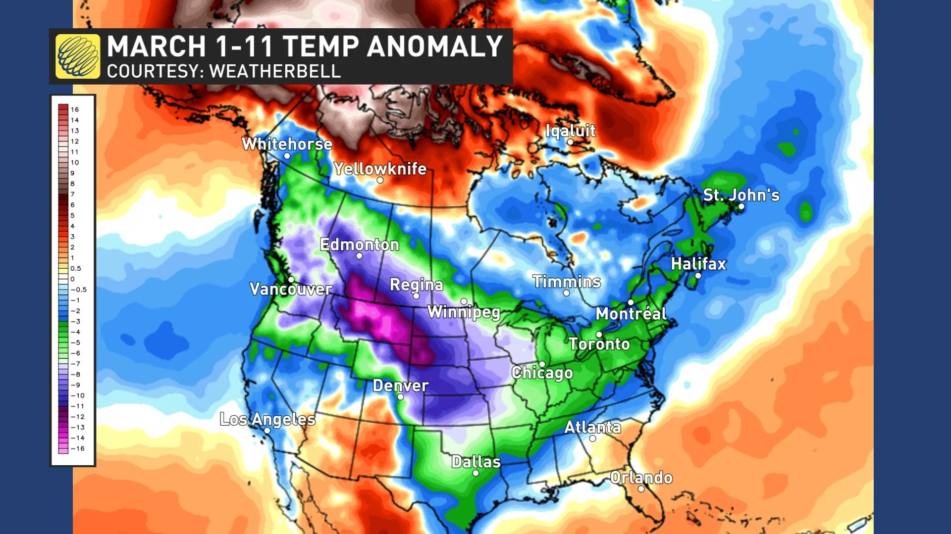
During the middle of March we had a dramatic reversal in the national weather pattern, especially across western Canada. Record cold was quickly replaced by record warmth with a few days of summer-like temperatures, especially across southern B.C.
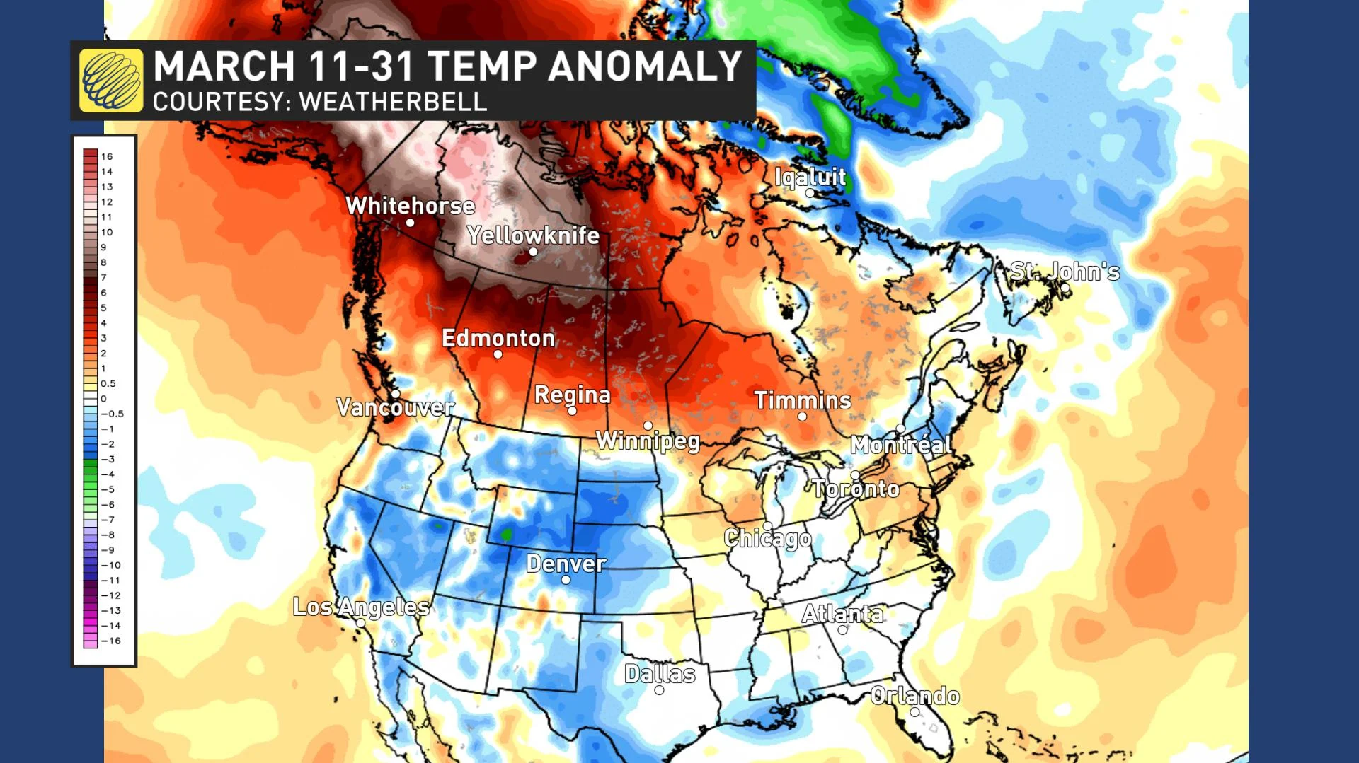
With the focus of the warm weather found across western Canada, the pattern change underachieved expectations across eastern Canada. For southern Ontario and southern Quebec, the amount of warming from early March to late March was more than double what is typical during that time period, so a pattern change did occur. However, there is no question that the weather did not get as warm as we expected.
TWICE AS FAST: A new Weather Network series on Canada's latest climate report
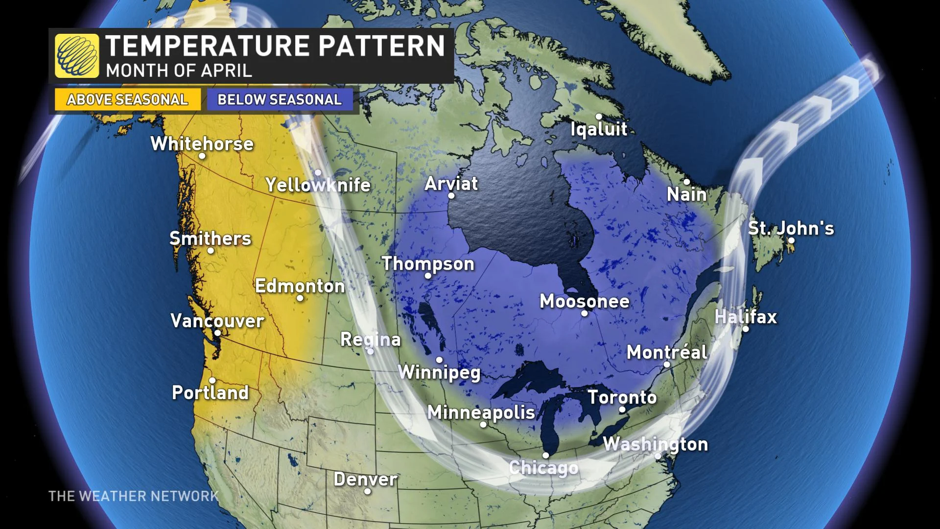
LOOKING AHEAD TO APRIL
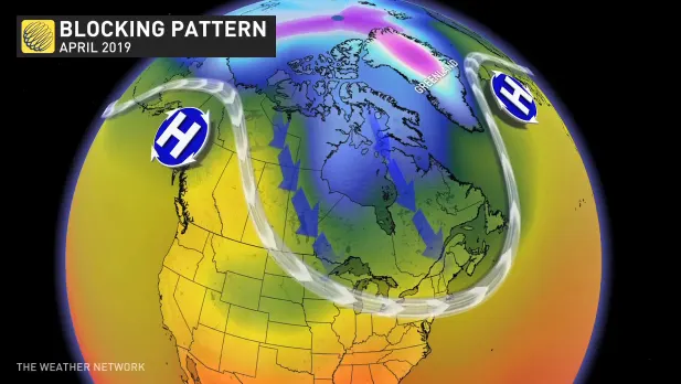
The blocking pattern that was responsible for delivering frequent shots of cooler weather into the eastern half of Canada during the second half of March is in the process of breaking down. This is bringing much colder weather into the regions of northern Canada that were so warm during March, and a much wetter pattern is returning to B.C.
However, this shift in the pattern is expected to be rather temporary. While the overwhelming majority of the models show a warm April across most of Canada, especially across eastern Canada, there are too many contrary signals in the global pattern for us to go along with those forecasts.
We expect that a weaker version of the blocking pattern will return to western Canada during the second week of April. In addition, we expect that a blocking pattern will also set-up over Greenland. This pattern is notorious for preventing sustained warmth during spring from the eastern Prairies to the Maritimes. In fact, it is eerily similar to what happened during the middle of April last year when temperatures were well below normal.
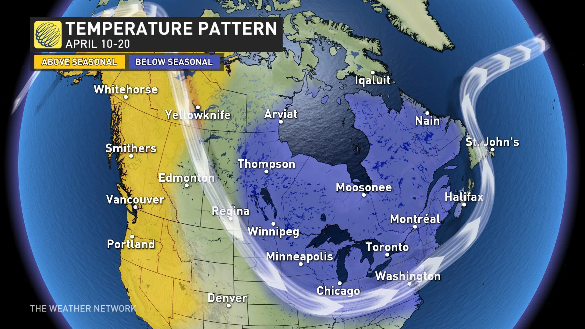
As we look at the month of April as a whole, all of Canada will continue to experience back and forth swings in temperature, but the more consistent warmth is expected to be limited to western Canada. It is too early to know how long the blocking pattern will persist, but if it continues well into the second half of April, then we will need to expand the colder than normal temperatures even further to the south.