
Tornado warning issued in southern Ontario as severe storms move in
A tornado warning has been issued in southern Ontario Tuesday evening.
6:49 p.m.. EDT - Severe thunderstorms prompted a tornado warning in southern Ontario on Tuesday.
Environment and Climate Change Canada issued a tornado warning for the following areas in southern Ontario:
Brantford
County of Brant
Simcoe
Delhi
Norfolk
First tornado Location: Over Burgessville Second tornado location: Springford
Motion: Moving quickly to the east at 80 km/h
Hazards:
Tornado
Wind: damaging (90 - 110 km/h)
Hail: up to quarter size (up to 2.5 cm)
"This is a dangerous and potentially life-threatening situation. Take cover immediately, if threatening weather approaches," ECCC said in its warning.
The agency added: "Go indoors to a room on the lowest floor, away from outside walls and windows, such as a basement, bathroom, stairwell or interior closet. Leave mobile homes, vehicles, tents, trailers and other temporary or free-standing shelter, and move to a strong building if you can. As a last resort, lie in a low spot and protect your head from flying debris.”
The original article with the full forecast for Ontario continues below.
Southern Ontario's summer-like warmth will come to an abrupt end later Tuesday, as a powerful cold front triggers another round of potentially severe thunderstorms across the province.
The threat will intensify throughout the afternoon and evening as heat and humidity rise ahead of the approaching front. Some communities may experience heavy rain, damaging wind gusts, and large hail before much cooler air arrives overnight. The chance for a tornado cannot be ruled out.

Be sure to stay up-to-date on any weather alerts or warnings in your area.
Storms ramp up late afternoon into Tuesday evening
The first thunderstorms are expected to form in the mid-to-late afternoon in areas near Lake Huron and Georgian Bay, including Barrie.
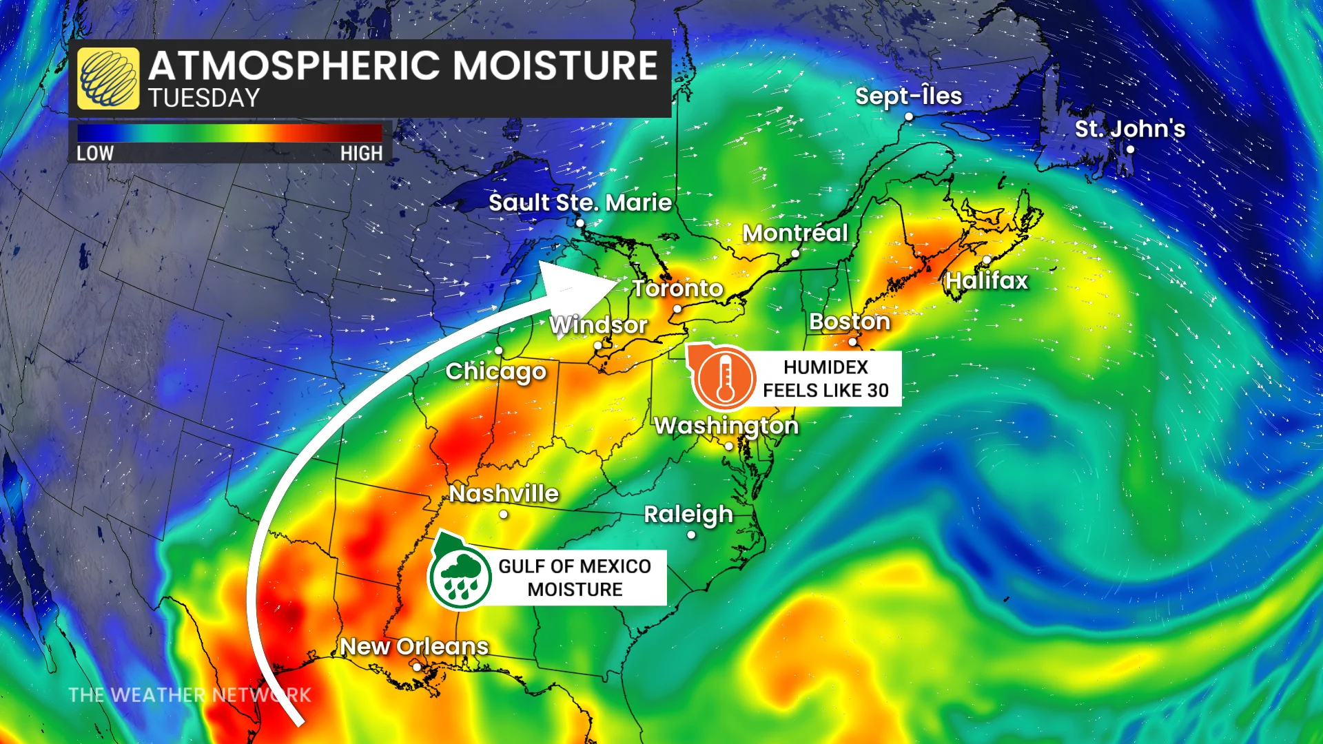
The focus will then shift south and east throughout the evening as a more organized line of storms moves along the 401 corridor from the Greater Toronto Area (GTA) to London, Windsor and Sarnia. The strongest storms are most likely to hit southwestern Ontario, where the line may remain more intact as it moves eastward.
DON'T MISS: Lightning safety tips: What you need to know to stay safe
High-risk areas may experience frequent lightning, damaging wind gusts and large hail. Localized flooding may also happen quickly after repeated heavy downpours.The storm threat should gradually shift east overnight, with the cold front moving into Quebec by early Wednesday morning.
WATCH: Cold front brings severe storms and major temperature drop to Ontario
Dramatic cooldown follows overnight
Behind the front, temperatures will plummet in southern Ontario by Wednesday morning.
SEE ALSO: How lake breezes shape your weather
Some communities may experience temperature drops of more than 20 degrees in less than a day. Barrie is forecast to fall from around 28°C Tuesday afternoon to near 6°C by early Wednesday, while London could drop from near 30°C to roughly 7°C overnight.
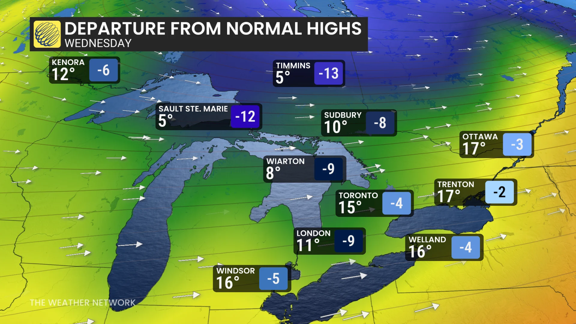
The cooler air will bring gusty winds and a very different feel than the summer-like warmth experienced earlier this week.
By Wednesday, much of southern Ontario will be waking up to temperatures that feel more like spring, with the severe weather threat shifting primarily south of the border and towards Atlantic Canada.
Stay with The Weather Network for the latest across Ontario