Snowfall continues to pileup ahead of late week rainy system

The pesky storm currently hitting Atlantic Canada is in for an extended stay, producing wintry conditions to start the work week.
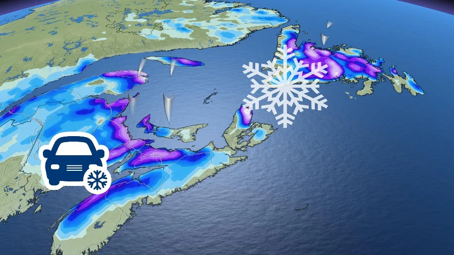
A low-pressure system continues to pinwheel across Atlantic Canada bringing ongoing wintry conditions across the region. Because it isn’t moving anywhere in a hurry, forecasters expect this to be a long-duration event, lasting through Tuesday for some areas. By the time it concludes, some areas could end up with more than 30 cm of snow.
The unwelcomed storm that hit Atlantic Canada this weekend is prolonging its stay. The low-pressure system will continue to bring snow and rain across the region.
The wintry weather will make for poor travel Monday as roads become slick and visibility can be reduced.
Environment and Climate Change Canada (ECCC) has issued Rainfall warnings and special weather statements across Newfoundland. While special weather statements have been issued for New Brunswick and eastern Nova Scotia.
New Brunswick will take the brunt of the heaviest snowfall, with some areas expected to see 30+ cm through Tuesday, especially near Moncton.

Sections of Newfoundland and Cape Breton Island in Nova Scotia could see 15-30 cm, while northern sections of the latter province could see 5-15 cm.
“Blustery coastal winds will make for some blowing snow and reduced visibility at times for P.E.I., eastern New Brunswick, and Colchester and Cumberland County of Nova Scotia,” says Kelly Sonnenburg, The Weather Network meteorologist.
“Precipitation will begin to ease through Tuesday with lingering snowy weather for eastern New Brunswick and PEI. Most precipitation will have departed Newfoundland by Tuesday afternoon,” says Sonnenburg.
Conditions will remain fair through mid-week before the next system moves in for Friday.

The new system will have mild air, with the potential for temperatures to climb into the low double digits for some areas. “The bulk of the system will produce rain into Christmas Eve so it might be difficult for some areas to hang onto their fresh snow from the beginning of the week into Christmas morning,” says Sonnenburg.