More closures, outages as potent storm continues to impact East Coast

More delays and cancellations across Atlantic Canada Wednesday as a potent winter storm continues to blast the region with heavy snow, blustery winds and rainfall
The biggest snowfall of the season so far hits Atlantic Canada after an unusual snow drought. It led to numerous travel and school interruptions Tuesday, with several closures and cancellations as a result of the heavy snow, intense winds and rainfall. The system isn't finished, just yet either, with significant impacts continuing into Wednesday.
DON'T MISS: Blizzard, twisters likely as 3,000 km-long storm eyes Canada, U.S.
Environment and Climate Change Canada (ECCC) has issued winter storm, snowfall, rainfall and wind warnings across the region, along with special weather statements.
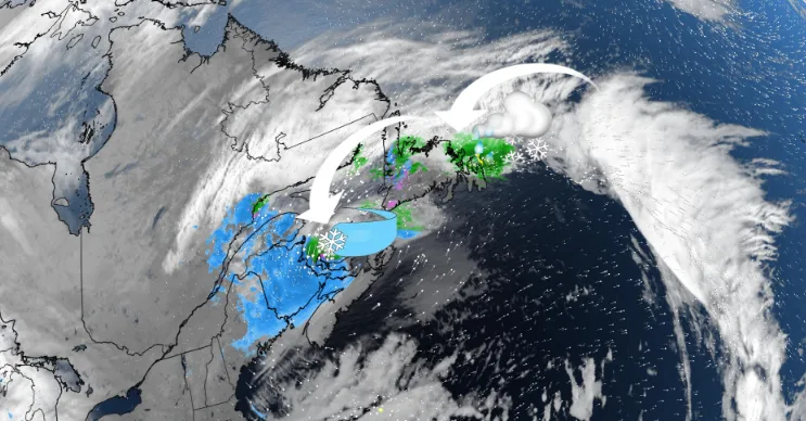
Atlantic Canada's snowfall start has been a sluggish one. While the snow drought continues for some, this mid-December system is delivering the season's biggest snowfall so far to many Maritime cities. Where the snow hits, blizzard-like and whiteout conditions threaten Wednesday commuters.

About 14,000 customers were still without power in Nova Scotia Wednesday morning, with the largest outages spread across the eastern part of the mainland and Cape Breton.
Several school buses were also cancelled, as well as morning classes for schools in Cape Breton. The majority of schools were closed across New Brunswick Wednesday morning.
It's more than eight months, and still, Halifax, N.S., has not recorded any measurable snowfall -- a whopping zero per cent of the normal amount for this time of the year. The city is also expected to miss accumulating snow with this mid-week system, allowing for the snow drought to continue.
As a result, Halifax might make a run at the second-latest measurable snowfall event as the next best chance comes next week.
A similar trend emerged in Charlottetown, P.E.I., where snow totals are sitting at less than 6 percent and Moncton at 28 percent through November. The end of the snow drought is afoot, however, with a stalled low piling up snowfall upwards of 20-40 cm and travel impacts through Wednesday.

The biggest danger zone lies on the eastern shores of New Brunswick through Wednesday. Heavy snowfall, coupled with gusty, 60-80km/h onshore winds, will make for dangerous whiteout conditions, especially on Wednesday morning. Commuters should consider avoiding travel along highways 8 and 11.
Snowfall will continue to stack up for P.E.I. and the Bay of Fundy shores through Wednesday. Winter storm conditions will then improve late Wednesday into Thursday morning.

In the long range, another messy system is set to move in for the weekend. Northern areas of the East Coast will see snow, while the south could end up with rain.
Stay tuned to The Weather Network for the latest forecast updates on Atlantic Canada.