Tropical storms Laura and Marco set for U.S. landfall next week

Tropical storms Laura and Marco are still on track to make landfall within 24 hours of each other onto the U.S. Gulf Coast next week.
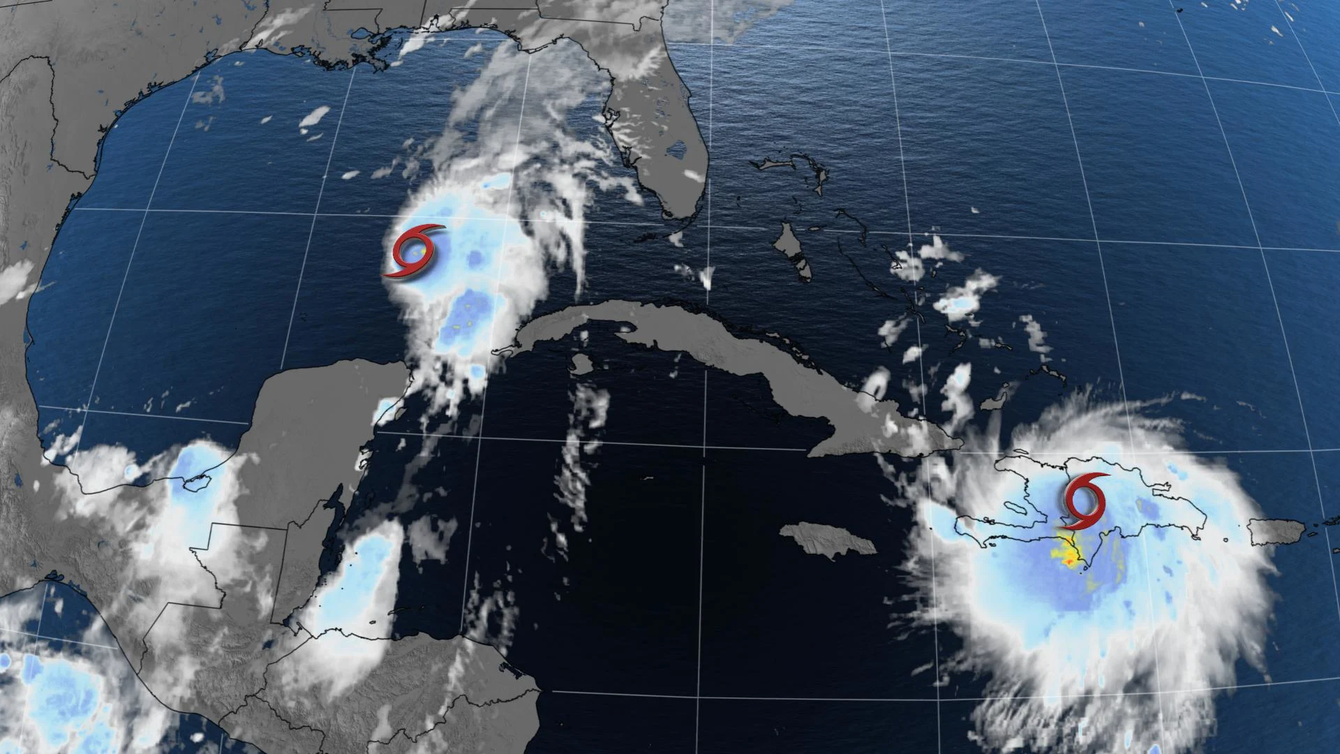
Two tropical storms are bringing torrential downpours to different areas of the Caribbean this weekend, and forecasters are eyeing both for potential tracks with will take them toward separate U.S. landfalls in very quick succession -- Late Monday/early Tuesday for Tropical Storm Marco and Wednesday/Thursday for Tropical Storm Laura.
TROPICAL STORM MARCO
This storm reached tropical status soon after appearing in the eastern Caribbean, and has been impacting much of Central America on its gradual passage through the region.
As of Sunday morning, the storm was gradually moving northward through the Gulf of Mexico, and forecasters are turning their attention to the U.S. Gulf Coast, where the strengthening storm is set to make landfall late Monday night or early Tuesday morning.
"Some strengthening is anticipated and Marco is forecast to become a hurricane later today and be at hurricane strength when it approaches the northern Gulf Coast on Monday. Rapid weakening is expected after Marco moves inland," the U.S. National Hurricane Center says.

Hurricane, tropical storm and storm surge warnings are in effect from Louisiana to northern Florida, ahead of storm surge as high as two metres, and 50-100 mm of rainfall, with isolated amounts in excess of 150 mm possible.
TROPICAL STORM LAURA
Further east, Tropical Storm Laura's heaviest impacts so far have been on Puerto Rico and the island of Hispaniola, and by Monday morning the storm is set to slam much of Cuba.
Tropical storm watches and warnings range from the Bahamas through the Dominican Republic, Haiti and Cuba as the storm continues to progress, likely remaining at Tropical Storm status throughout.
As much as 100-200 mm of rain is expected from this storm in those regions as it passes, with isolated local amounts of up to 300 mm possible as well, raising the risk of life-threatening flash flooding and landslides.
Beyond Cuba, the storm may strengthen over the warm Gulf of Mexico to a full-on hurricane, and by the early morning hours of Thursday it will be targetting the areas of the U.S. Gulf Coast that will have already felt an impact from Marco.

MORE: A CLOSER LOOK AT WHAT'S DRIVING THESE TWO TROPICAL STORMS
TWO LANDFALLS AROUND SAME TIME POSSIBLE IN U.S. NEXT WEEK
Weather Network meteorologist Erin Wenckstern says this two-storm setup has complicated forecasters' work.
"Hurricane forecasting is a delicate act. Multiple factors contribute to the strength and direction a hurricane travels, including wind, ocean temperatures and the overall atmospheric pattern, which steers the storm. Add a second storm into the mix and the forecasting becomes exponentially more complex as the two storms can interact and affect one another," says Wenckstern.
There have never been two hurricanes in the U.S Gulf of Mexico at the same time, according to the NHC. The closest event was in 1933, when a major hurricane made landfall in south Texas while a separate hurricane weakened to a tropical storm after crossing the Florida Peninsula, as reported by Reuters.
According to Philip Klotzbach, a meteorologist at Colorado State University, the shortest time between two separate hurricane landfalls to hit the United States is 23 hours, between the Treasure Coast hurricane and the Cuba/Brownsville hurricane on Sept. 4-5, 1933.
Follow along to watch the development of these August storms.