
April begins with major wintry rewind in eastern Ontario, Quebec

The next storm system that threatens eastern Ontario and southern Quebec on Thursday is no April Fools' joke.
The timing is ironic, but a potent wintry system that targets eastern Ontario and southern Quebec on April 1 is really no April Fools' Day joke. With frigid air being ushered in from northern Ontario, combined with coastal moisture flows in from the east, the west side of the storm may deliver a significant swath of snow over Ottawa, Montreal, Quebec City and areas east of the latter.
While nothing significant is anticipated for southern Ontario, a few flurries may make their way into cottage country and the Greater Toronto Area, especially as temperatures dive to values more typical of late February. Snow totals will be highly track-dependent, but at this point, as more than 25 cm could fall over the hardest-hit areas in Quebec through Thursday. More on what we know so far, below.
WEATHER HIGHLIGHTS:
Temperatures drop Wednesday as cold front treks through, light showers for south in the morning
Winter-like storm threat for eastern Ontario and southern Quebec through Thursday, though the exact track of the storm is still uncertain
Potential for significant snow amounts for Ottawa, Montreal, along the St. Lawrence and across the Eastern Townships, snow flurries for the GTA
Clearing conditions in time for the Easter weekend
After a brief fling with the mild temperatures Tuesday, they will fall back to Earth Wednesday, thanks to a gusty northwest wind accompanying a strong cold front crossing the region. This will also bring light showers that may persist into the afternoon for southern Ontario, hanging on into the evening for areas east extending into Quebec.
By the overnight hours, precipitation will change to snow in eastern areas of Ontario and western Quebec as temperatures drop.
SNOW JOKE: APRIL FOOLS' STORM LOOMS FOR THURSDAY
Forecasters are keeping a close eye on the setup for Thursday, as the same storm that has been battering the Prairies with harsh and dangerous wintry conditions will lay the foundation for a significant spring system for eastern Ontario and Quebec.
Visit our Complete Guide to Spring 2021 for an in-depth look at the Spring Forecast, tips to plan for it and much more!
"The storm will reach its demise on Wednesday as it tracks over Hudson Bay. The remnants of the cold front, however, will move over the Great Lakes and stall along the eastern seaboard," says Weather Network meteorologist Kevin MacKay. "Ample Gulf moisture will then funnel into the region, as a new low forms over New York."
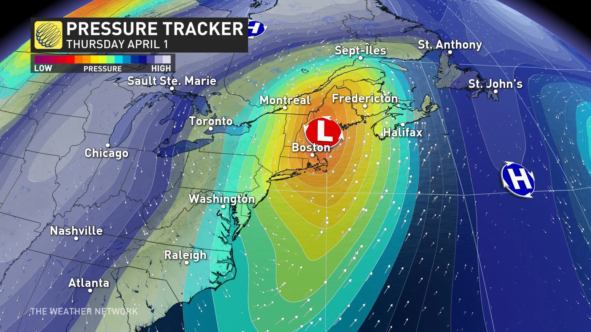
At this point, the storm looks to be tracking towards the mouth of the St. Lawrence by the end of the week. The new low will continue to pull Arctic air from northern Ontario, while coastal moisture flows in from the east.
By Thursday morning, snow will ramp up across eastern Ontario and Quebec, with the possibility of freezing precipitation south of the St. Lawrence River. A period of freezing rain and ice pellets may become more widespread in the afternoon in Quebec City and along the St. Lawrence northeast of Quebec City.
Snowfall totals will vary depending on location. 10-20 cm is forecast for southern Quebec, with Montreal just on the outside cusp of that total. The city could see 10-15 cm, though, while Ottawa can expect to see 10 cm. The heaviest snowfall will remain in far eastern Quebec, where more than 25 cm of snow is possible.

Rainfall amounts will be light across southern Ontario with most areas seeing less than 5 mm, though areas along Lake Huron shores and Georgian Bay may see up to 10 mm. Eastern Quebec may see 5-15 mm. The heaviest rainfall will remain stateside and push into Atlantic Canada for later on Thursday.
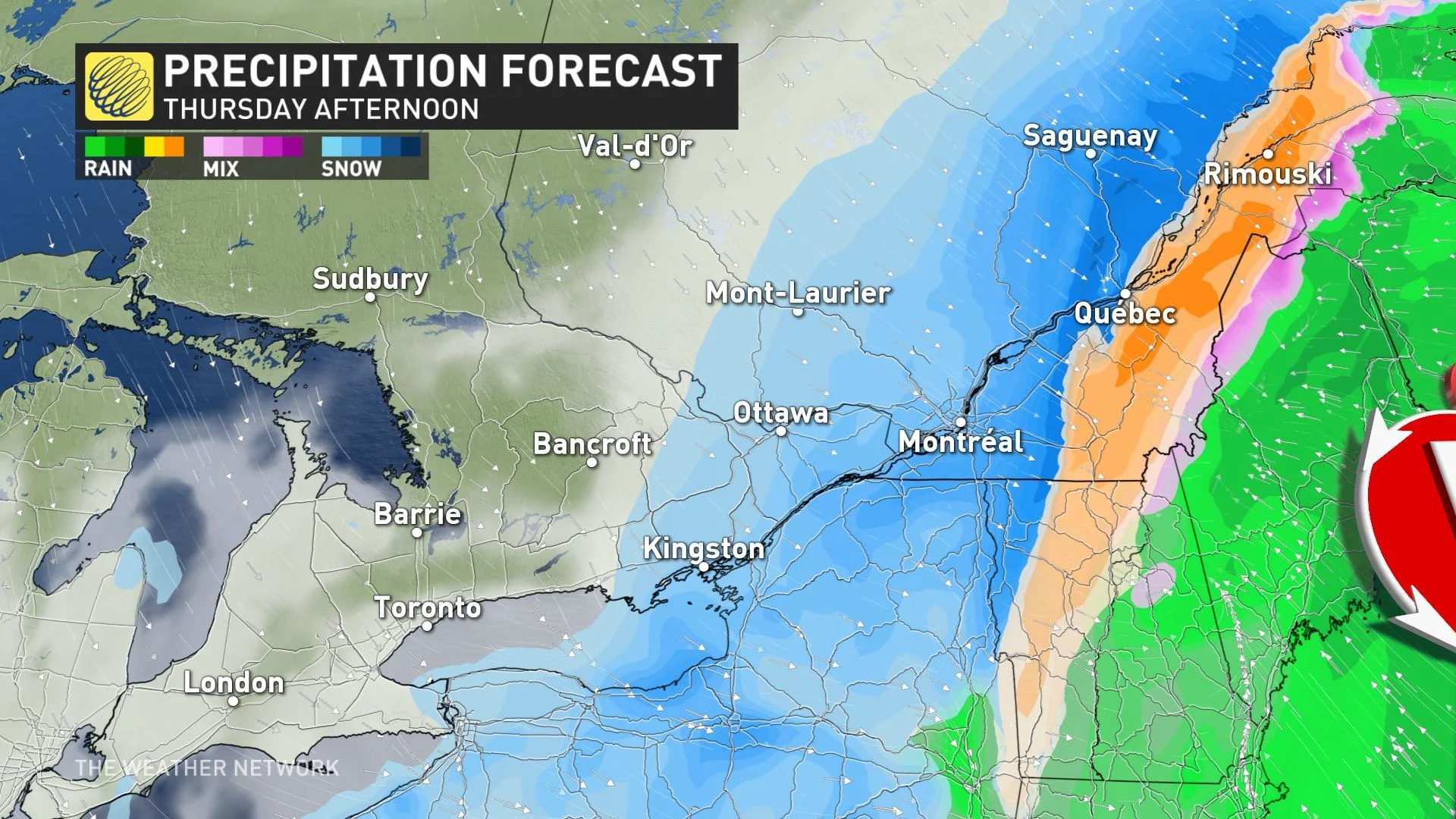
With much colder air funnelling in behind the front, temperatures will be more typical of late February across southern Ontario on Thursday, along with the chance for flurries across the Greater Toronto Area, and lake-effect snow for areas southeast of Georgian Bay and Lake Huron.
EASTER LONG WEEKEND STARTS OUT COOL, BUT WARMS NICELY THROUGH SUNDAY
Temperatures will remain on the cool side of seasonal for Friday, though with morning clouds giving way to abundant sunshine for the start of the holiday weekend.
Temperatures will continue to climb back into double digit territory by Easter Sunday across the south, with pleasant weather persisting through Monday as well.
"The good news story here is that we'll avoid a 'white Easter' across southern Ontario this year," says Weather Network meteorologist Dr. Doug Gillham.
Be sure to check back as we continue to monitor the track of this incoming winter-like system.


