Tornado warnings ended, but severe storms still ongoing in Ontario

Severe thunderstorm risk is very high for parts of southern Ontario, with several tornado warnings issued at one point, with the warned storms roving from Barrie through the northern GTA toward Peterborough and the Kawarthas.
Tornado-warned storms rolled through the Barrie area and northern GTA Thursday afternoon, with reports of injuries and extensive damage in one neighbourhood in Barrie. Though they eventually dropped around 4:40 p.m., a second round of warnings for storms rolling through the Peterborough and Kawartha Lakes dropped soon after 6 p.m. However, severe thunderstorms are still ongoing in some parts of the province. For meteorological analysis, see below.
THURSDAY: A RISK FOR SEVERE STORMS
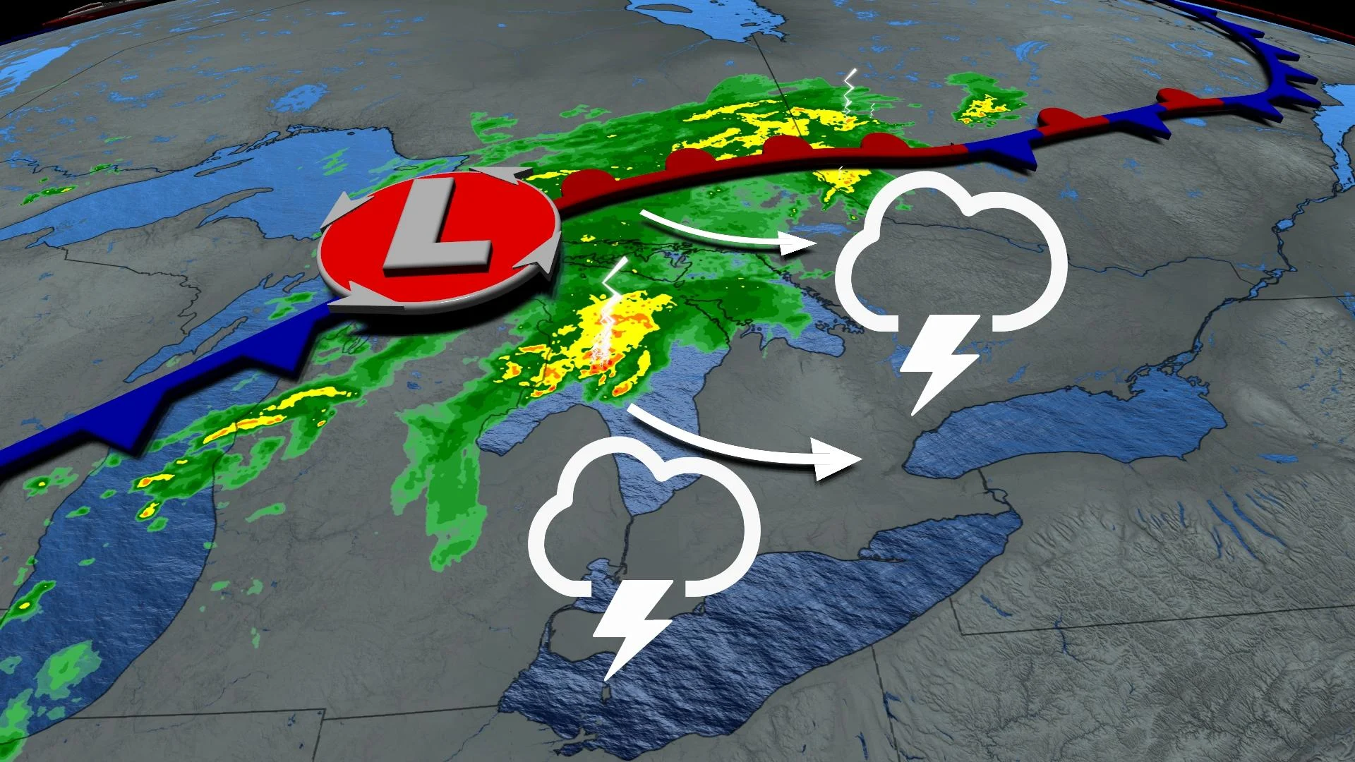
A low-pressure system will move across the Great Lakes into northern Ontario during the day on Thursday. As the low tracks north, a cold front will sag into southern Ontario.
This cold front will push into the warm, unstable air blanketing the region, setting the stage for the severe thunderstorms expected to develop on Thursday afternoon and evening.

RELATED: What to do in case of a tornado warning
The strongest thunderstorms that develop on Thursday could produce damaging winds, large hail, and heavy rainfall. A couple of tornadoes are also possible.
Timing is key when it comes to Thursday’s storms. The severe weather threat will be maximized where the cold front’s passage coincides with the greatest instability during the afternoon hours.

Right now, it looks like the greatest threat for severe weather will exist along and east of the shores of Lake Huron and Georgian Bay, extending into cottage country. This is where the cold front will collide with the day’s greatest instability.
With strong instability in place and plenty of lift along the cold front to trigger to development of thunderstorms, much of the severe threat on Thursday will be driven by strong wind shear throughout the atmosphere.

SEE ALSO: Lightning frequency is creating a new reality of wildfires in North America
Storms across southwestern Ontario are likely to form into a QLCS (quasi-linear convective system), commonly known as a squall line, as lower-level and upper-level winds are somewhat aligned with one another.
Lines of thunderstorms are known for their damaging straight-line winds and heavy rains, as well as the potential for spin-up tornadoes along the leading edge of the storms.
Farther north, closer to the centre of low pressure itself, winds will blow from the south near the surface and from the southwest higher up in the atmosphere. This directional wind shear can allow individual thunderstorms to develop and begin rotating.

These discrete rotating storms are possible from Barrie northward through cottage country. Rotating storms can pose a threat for tornadoes, as well as damaging winds and large hail.
Thunderstorms will clear out of southern Ontario from west to east as the evening progresses, and the risk for severe thunderstorms should diminish after nightfall.
Thursday will also be the warmest day in what has already been a scorcher of a week, with afternoon highs in the upper 20s to around 30°C, with humidity pushing the feels-like into the mid-30s.

FRIDAY AND BEYOND: BRIEFLY BELOW-SEASONAL BEFORE WARMTH RETURNS NEXT WEEK
While the storms will move out on Thursday night, clouds and rain will stick around through Saturday. The next couple of days are likely to be a bit grey, rainy, and humid, with slightly below-seasonal highs during the afternoon hours.
Conditions should calm down later this weekend. Near- to above-seasonal temperatures, sticky humidity levels, and an occasional chance for passing showers and thunderstorms will return by next week.
Stay with The Weather Network for the latest on the storm threat across southern Ontario.