
Tornado warning issued in Saskatchewan amid severe storms
Prepare for another busy day of severe weather across southern Saskatchewan as an active pattern remains locked over the region
__4:14 p.m. CST __ - Severe thunderstorms prompted a tornado warning in southern Saskatchewan on Friday afternoon.
Environment and Climate Change Canada issued a tornado warning for the following areas in southern Saskatchewan:
R.M. of Hillsborough including Crestwynd and Old Wives lake
R.M. of Lake Johnson including Mossbank and Ardill
R.M. of Meota including Meota and The Battlefords Prov. Park
R.M. of Parkdale including Glaslyn and Fairholme
R.M. of Rodgers including Coderre and Courval
R.M. of Sutton including Mazenod Palmer and Vantage
R.M. of Turtle River including Edam and Vawn
"This is a dangerous and potentially life-threatening situation. Take cover immediately, if threatening weather approaches," ECCC said in its warning.
The agency added: "Go indoors to a room on the lowest floor, away from outside walls and windows, such as a basement, bathroom, stairwell or interior closet. Leave mobile homes, vehicles, tents, trailers and other temporary or free-standing shelter, and move to a strong building if you can. As a last resort, lie in a low spot and protect your head from flying debris.”
CURRENT TORNADO WARNINGS (SASKATCHEWAN):
R.M. of Hillsborough including Crestwynd and Old Wives lake
R.M. of Lake Johnson including Mossbank and Ardill
R.M. of Meota including Meota and The Battlefords Prov. Park
R.M. of Parkdale including Glaslyn and Fairholme
R.M. of Rodgers including Coderre and Courval
R.M. of Sutton including Mazenod Palmer and Vantage
R.M. of Turtle River including Edam and Vawn
The original article with the full forecast for the region continues below.
Beware a risk for severe thunderstorms again on Friday as a stormy stretch of weather persists across portions of the Prairies.
Rotation is possible. Stay alert for rapidly changing conditions, and pay close attention to watches and warnings as you go about your day.
DON’T MISS: Canada’s July outlook holds a major flip-flop across the country
Friday storm risk covers major population centres
Friday’s risk for severe storms will build over a very similar area as Thursday’s rough storms thanks to a surface trough and centre of high pressure over northern Manitoba stalling the pattern over the region.
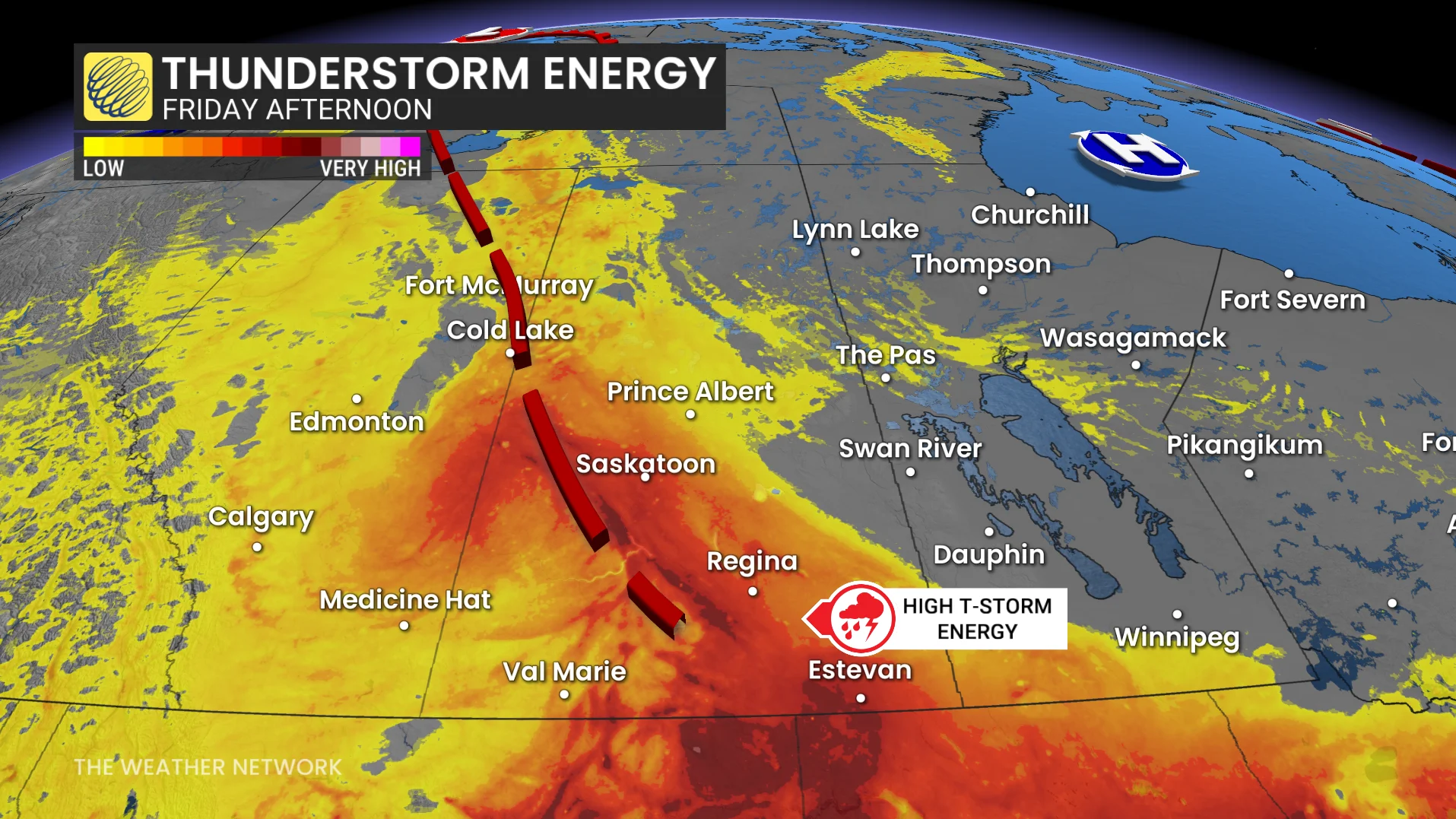
A trough extending from northeastern Alberta through southeastern Saskatchewan will serve as the trigger and focus for rough storms through the day Friday.
The better chance for isolated severe storms will build over southern Saskatchewan, where thunderstorm cells will have the opportunity to develop independently. Discrete storms carry the best chance to produce hail and rotation.
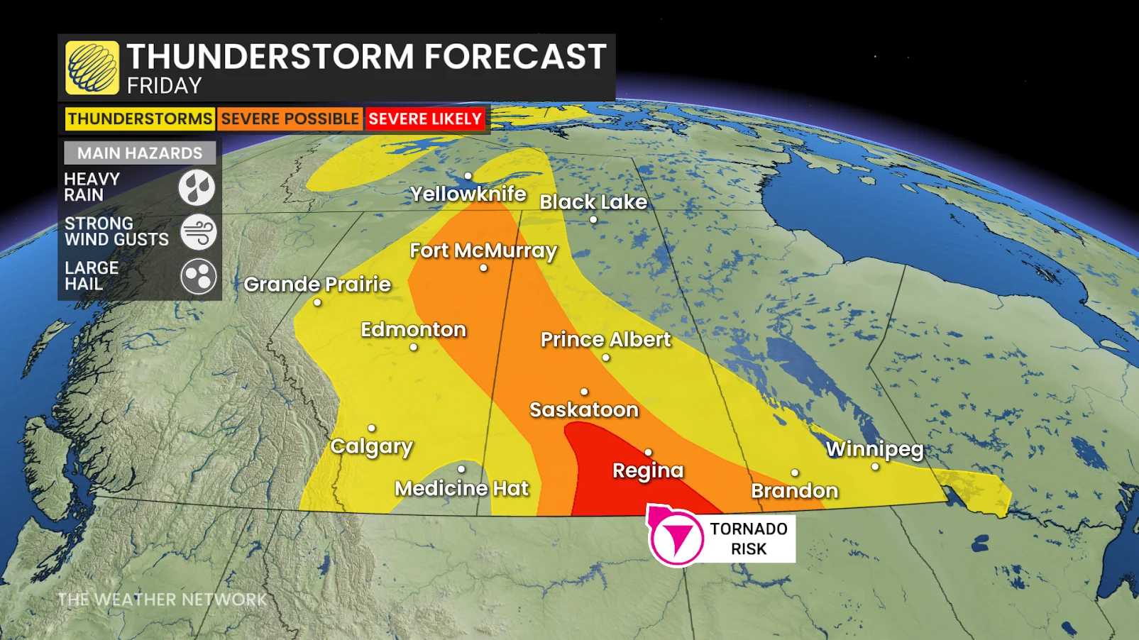
Friday’s strongest storms will carry the risk for strong wind gusts up to 100 km/h and heavy rainfall. Folks may also see up to ping-pong ball-sized hail in some of the stronger storms.
While we’re lacking notable wind shear across the region, we’ll still see a relatively low tornado risk north of the border.
Some of the storms could persist into the overnight hours across southeastern Saskatchewan as they cross the border into southwestern Manitoba.
Always have a plan in place in case a tornado warning is issued for your location. We’re quickly approaching the peak of tornado season across Canada.