
Potential for damaging hail, tornado risk on eastern Prairies Tuesday

A new week and a renewed thunderstorm threat across parts of the Prairies, including large hail and a tornado chance for southern Manitoba on Tuesday
The Prairies' latest run of stormy weather will continue this week, with a widespread chance for thunderstorms and a threat for very large hail and a limited window for one or two tornadoes for some on Tuesday.
A strong trough dipping over Western Canada is to blame for the ongoing series of severe thunderstorms we’ve seen over the past couple of days. The low will scoot farther east, bringing a risk for storms to much of Manitoba again on Tuesday.
DON’T MISS: Heavy rain soaks central Alberta as wildfire evacuees prepare to return home
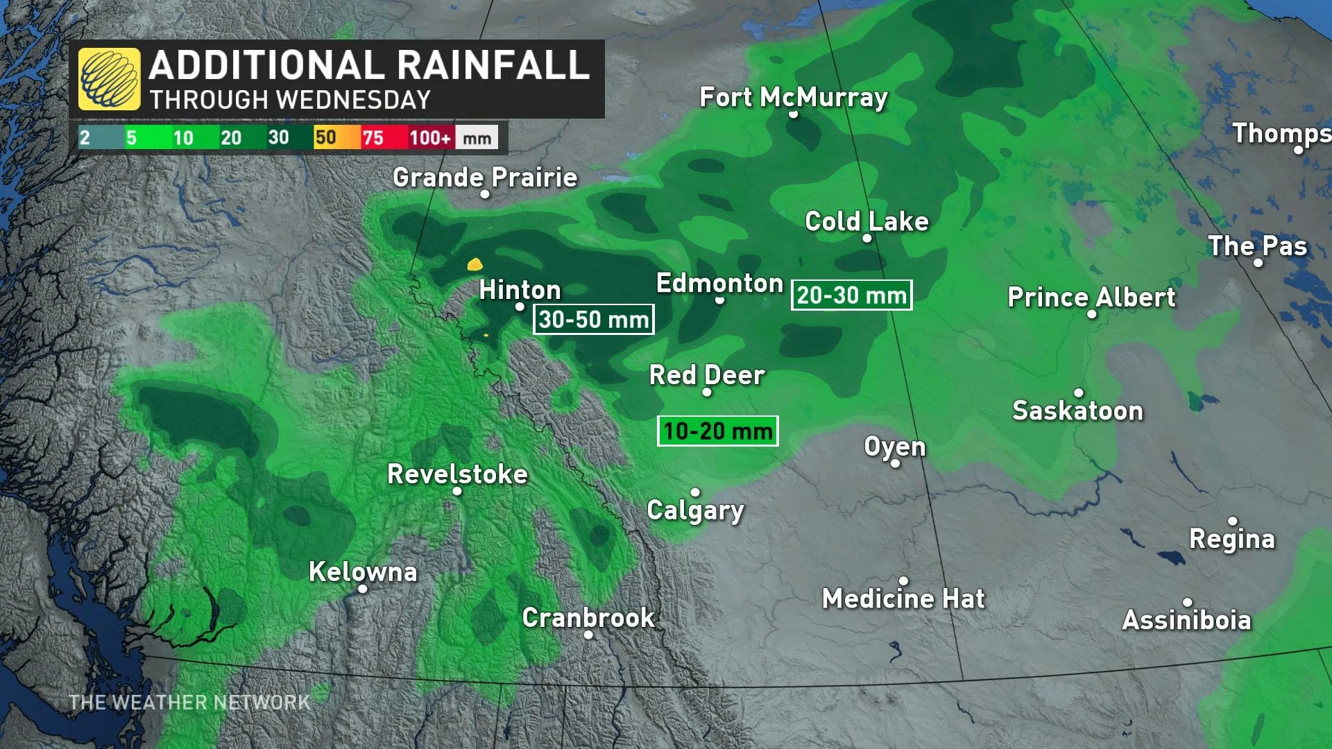
Meanwhile, farther west, central Alberta has seen substantial rainfall, which prompted the Town of Edson to declare a state of local emergency after flooding ensued. But the rain is a welcome sight, both for agricultural areas and for regions hit hard by a historic start to this year’s wildfire season.
Tuesday
Areas: Southern Manitoba and northwestern Ontario
Timing: Late afternoon and evening
Weather: Forecasters are tracking a primed environment capable of very large hail, one or two tornadoes and localized flooding in a narrow band of severe weather. An enormous amount of thunderstorm energy and moisture exists as daytime temperatures climb into the high 30s, feeling like the 40s in the south.

A trough will prop up thunderstorms with ease, allowing strong updrafts and downdrafts that could carry hail up to tennis ball-size, especially in the red-highlighted region. Initially, supercells could develop and have a slight risk to rotate and form a tornado. Into the evening, the storms will form a line, risking damaging wind gusts ahead of it and during. The severe weather tracks towards the northeast, potentially in the form of training thunderstorms and localized flooding if the trough becomes slow-moving.
MUST SEE: Stuck in your car during a tornado? Here’s what you should do
Excessive rain hits parts of Alberta
While folks on the eastern Prairies contend with thunderstorms and a tornado risk, a heavy and steady rain has blanketed parts of Alberta.
The 100+ mm of persistent rain will ease through the day on Tuesday. But with so much rain last week and over the weekend, the Town of Edson has launched a local state of emergency. There is the risk for localized flooding to the northern foothills until a drier pattern change builds mid-late this week.
Avoid driving through water on roads. Even shallow, fast-moving water across a road can sweep a vehicle or a person away. Don't approach washouts near rivers, creeks and culverts.
Heavy and persistent rains falling over burn scars will lead to increased runoff and a risk for localized flooding. Stay aware of the potential for rising water in vulnerable areas, and continue to monitor local weather alerts in the days ahead.
WATCH: What a growing El Niño means for Canada's weather this summer
Check back frequently for the latest updates on conditions across the Prairies.
Thumbnail photo courtesy of Charles Dunham/UGC, taken in Winnnipeg, Man.