
Storm turns to Newfoundland with disrupting impacts as Maritimes dig out

The storm shifts its focus to Newfoundland into Tuesday after bringing hazardous conditions from heavy snowfall and intense winds to the Maritimes to kick-start the week.
Another potent winter storm is winding down in Atlantic Canada as we head into Tuesday. The Maritimes will see improving conditions as snow and the winds ease, but travelling may still be tricky overnight, with possible localized whiteouts from blowing snow. Newfoundland will be in the thick of the precipitation into Tuesday morning, including ice pellets or snow. Precipitation transitions into flurries in behind the low as sea-effect snow takes overs in eastern Nova Scotia and parts of Newfoundland for Tuesday, lingering into the overnight hours. By the time all is said and done, parts of the Maritimes could see 20+ cm of snow and 20-35 cm for parts of southern Newfoundland. Winds will be strongest in Newfoundland, where 80-90 km/h gusts will be possible into Tuesday morning, so motorists are urged to take extra precautions. More on the timing and impacts, below.
MUST SEE: Common household items that combat snow and ice
TUESDAY: TRAVEL MAY STILL BE TRICKY IN MARITIMES AS EFFECTS LINGER IN NEWFOUNDLAND
After heavy snow pushed through the Maritimes Monday, disrupting travel and affecting schools and businesses, it has since subsided as the storm continued trekking east into Newfoundland. While snow has eased off in the Maritimes, travel may still be tricky overnight due to blowing snow, possibly leading to localized whiteouts.

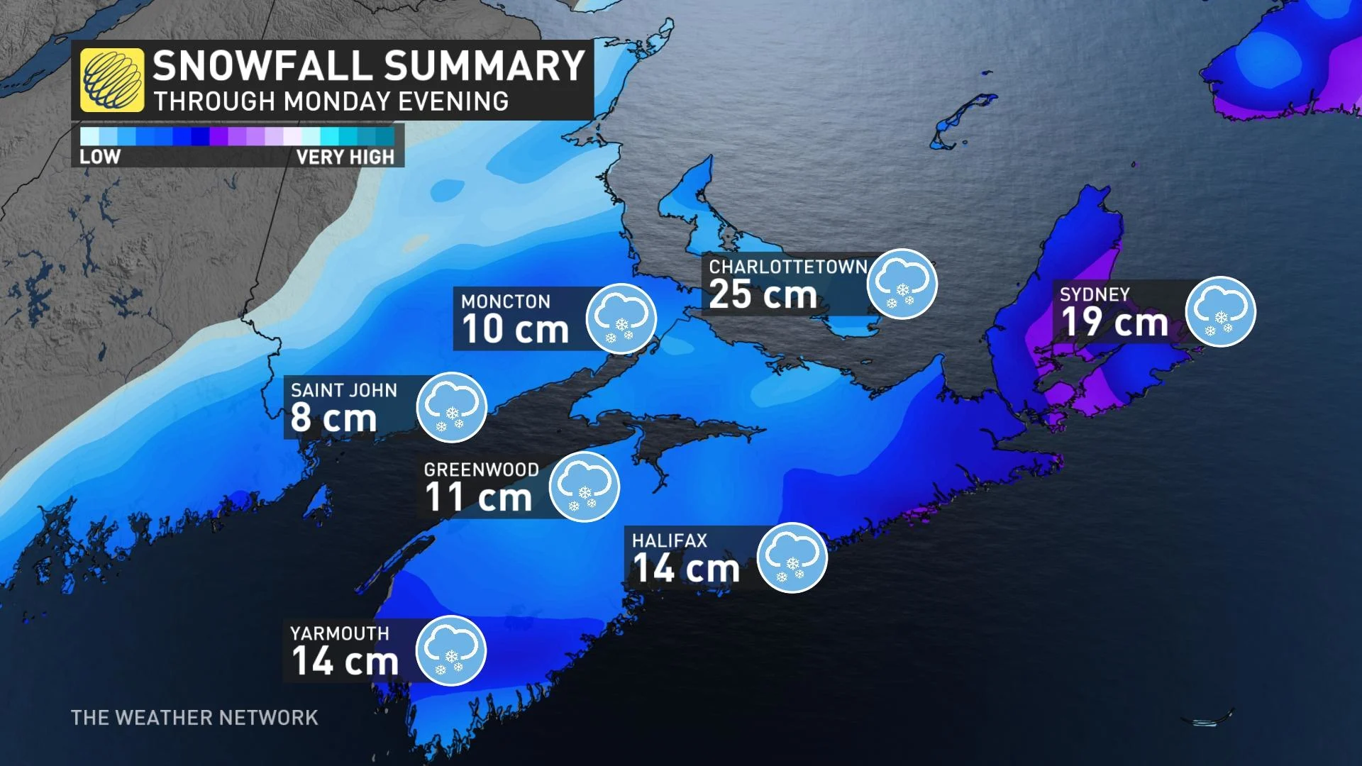
In the Maritimes, the bulk of the accumulating snow has fell over P.E.I., as well as southern and eastern Nova Scotia. As of Monday evening, Charlottetown, P.E.I., has seen 25 cm, while in Halifax and Sydney, N.S., there has been 14 cm and 19 cm, respectively.
As much as 40 cm of snow is possible for Cape Breton through Tuesday, including sea-effect accumulations.
A second push of snow will reach Newfoundland overnight Monday as a secondary low develops and moves through the region. During this wave, parts of extreme southern Newfoundland may see brief periods of ice pellets or freezing rain as some warm air tracks into the region.
TREACHEROUS TRAVEL IN HALIFAX AS SNOWSTORM CLOSES ALL SCHOOLS
The accumulating snow will wind down by Tuesday morning in Newfoundland. However, as the system departs, there will be sea-effect snow for western and eastern Newfoundland, as well as eastern Nova Scotia, lingering into overnight Tuesday.

Parts of the Avalon Peninsula could see the heaviest amounts, with 20-35 cm of snow forecast by Tuesday morning. Regions just north and west of the Avalon may see 15-20 cm.
While winds are subsiding in the Maritimes, they will remain intense across the Avalon, with 80-90 km/h gusts overnight Monday into Tuesday morning. Winds will make wind chill values feel even colder and could lead to reduced visibility during periods of blowing snow.
After a few days of very cold weather through the mid-week mark, much milder weather will return to the region late week. This will also bring a threat for widespread rain as a Colorado low tracks into the region.
Thumbnail courtesy of Luca Bourque, taken in Sluice Point, N.S., Feb. 14, 2022.
Check back for the latest on conditions across Atlantic Canada.