Atmospheric river drives up avalanche danger to 'high' for B.C.'s South Coast
Snow, rain and winds will come in waves through the weekend across B.C., with an elevated avalanche danger rating for the South Coast
The end to February's cold start is finally coming to British Columbia.
After weeks of below-seasonal temperatures—-thanks to a blocking pattern that left the West Coast in a ridge of high pressure—-we're finally seeing the pattern start to break down, opening the gates for warmer, moisture-packed air to return to the coast.
So far this year, B.C. has been in a rain deficit, with January only receiving 33 per cent of its average monthly rainfall. To date, February has only seen 14 per cent, as well.
SEE ALSO: Gulfs, lakes and cities: How places get their names
Now, in the second half of the month, we're looking at back-to-back systems that will bring rain and milder temperatures to the province, heightening the avalanche risk for coastal areas, as well.

Temperatures climb and rain falls through Thursday
Rain began along B.C.'s coast on Wednesday, persisting through much of the day on Thursday, as well.
Between 10-20+ mm of rain is forecast for Vancouver, and the rest of the Lower Mainland through Thursday, while Vancouver Island sees heavier totals between 30-50 mm. Victoria, on the other hand, has the benefit of geography in its side, with the surrounding mountains helping to limit the city's rain totals to 5-10 mm.
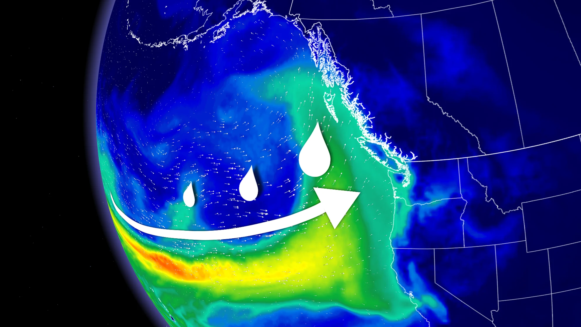
Atmospheric river takes aim at South Coast over the weekend
Another plume of atmospheric moisture will reach the South Coast by the weekend, further increasing rain totals in Vancouver and western Vancouver Island.
An atmospheric river will be impacting the United States southwest, with some of that excess moisture spilling northward into the South Coast. While the atmospheric river will be fairly weak, folks can expect waves of heavy rainfall that could cause some localized flooding.
The Lower Mainland will likely see an extra 50-100 mm of rainfall through Saturday, while areas north of the Fraser River can expect 80+ mm.

Daytime highs in Vancouver are expected to reach 10°C by the weekend—the first time the city has seen double-digit temperatures since Dec. 28, 2024.
The warm air will also be transported to higher altitudes as it spreads eastward over the Prairies, so we could even see some ski areas receive a bit of rain, as well.
This does, however, increase the risk for avalanches, as the warmer temperatures and rainfall loosens the snowpack.
High avalanche danger rating for the South Coast
The avalanche danger rating was bumped up to 'high' for Vancouver Island and the South Coast on Thursday.

"As precipitation piles up, danger increases with it," warns Avalanche Canada. "With storms this dramatic, it is a great time to avoid avalanche terrain until things calm down."
SEE ALSO: Skier dies in avalanche near Golden, B.C.
Freezing levels will rise to around 2000 m through the weekend, and together with the rain, could de-stabilize the snow-pack, and increase the risk of avalanches.

According to Avalanche Canada, a high danger rating means that conditions are very dangerous, and travel in avalanche terrain is not recommended.
Stay with The Weather Network for more forecast information and updates on your weather across B.C.