Ontario: Widespread snow threat may mean messy Thursday commute

Temperatures will slide across southern Ontario with more communities in line for their first snowfall of the season
The prolonged and below seasonal November pattern starts this week across southern Ontario. Temperatures began to tumble on Tuesday, and that trend continues through the week, ending with highs near the freezing mark by week's end. That means the chance for snow also increases, with the first measurable accumulations of the season possible for some people. Snowfall amounts will rely on the track of a system moving in later this week, but some impact to Thursday morning's commute is still likely. More on the timing and what we're watching, below.
Time to prepare for the season ahead! The Weather Network's Winter Forecast launches Monday, November 18.
WEATHER HIGHLIGHTS
Highs near freezing by late week
Several shots of snow in the forecast, including prolonged lake-effect
Colder-than-average temperatures dominate first weeks of November
Stay up-to-date on the ALERTS in your area
Southern Ontario found itself on the wrong side of a weak cold front Tuesday, with highs running about 5 degrees below Monday's balmy (for November) weather. And it's still downhill from here, as temperatures continue to fall for the rest of the week.
West winds threaten more lake-effect snow for parts of the province on Wednesday, with the most persistent bands expected to set up over cottage country, but the next significant system rolls in for Thursday.
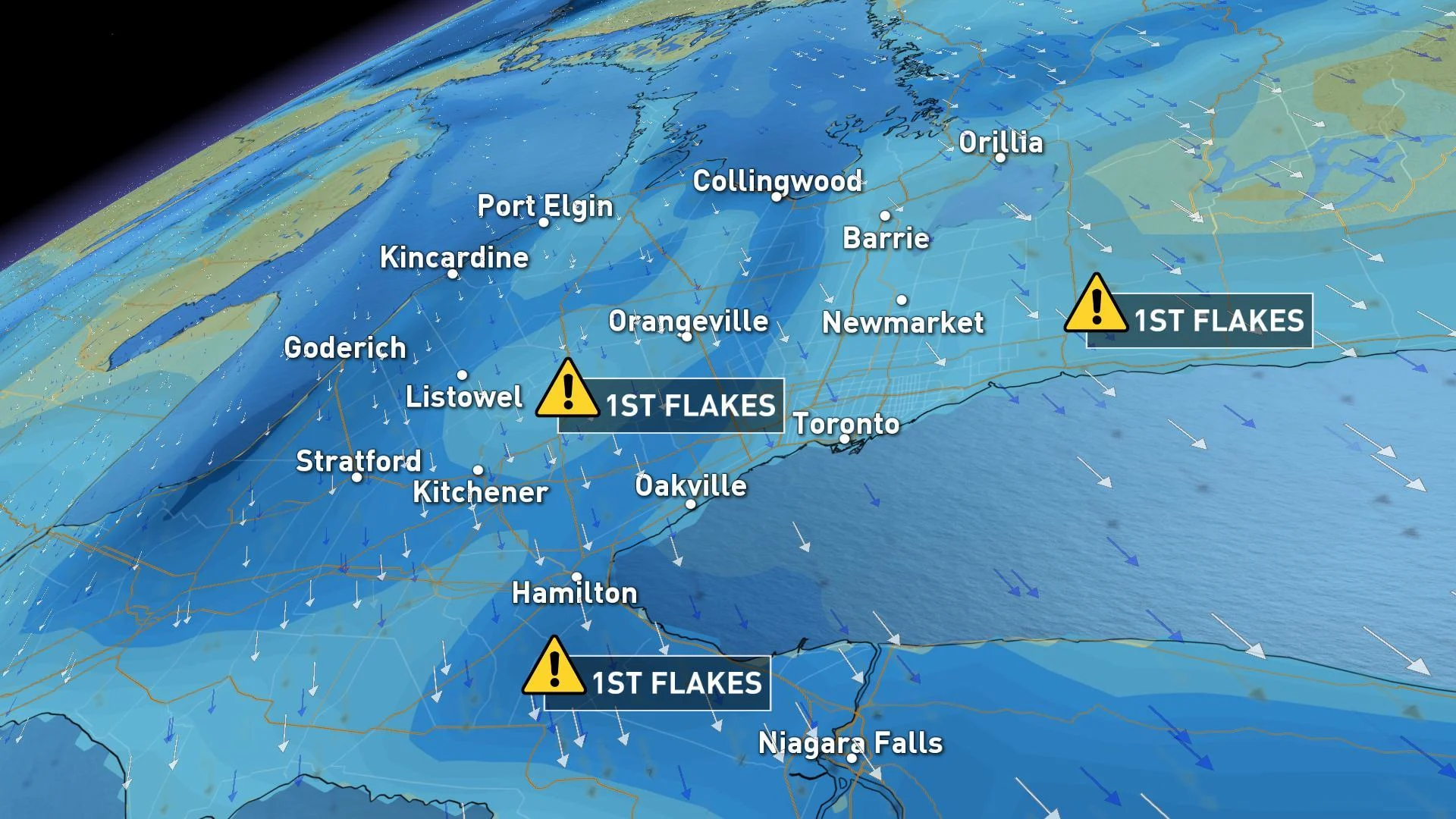
WIDESPREAD SNOW THREATENS THURSDAY MORNING COMMUTE TIMES
A weak disturbance is expected to track across southern Ontario on Wednesday, bringing the chance for a mix of rain and snow through the evening hours, though with no accumulation expected across the Greater Toronto Area.
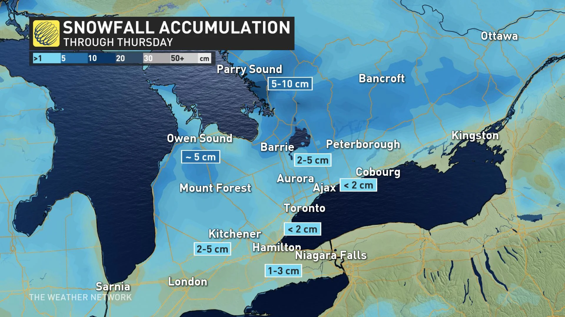
TIMING THE MULTIPLE SHOTS AT SNOW THIS WEEK
"This will likely be the first snow of the season for the GTA and Niagara region," says Weather Network meteorologist Dr. Doug Gillham, adding that the snow flurries will pick up during the predawn hours on Thursday.
"The snow will have trouble accumulating near the shoreline of Lake Ontario, but a slushy dusting is still possible," Gillham says. "Most places well away from the lakeshore and especially north of the 401 and above the escarpment could end up seeing between 2-5 cm."
MUST READ: Typhoon Halong hampers any dream of a notable November warm-up
While accumulations won't be significant, this first snowfall could have an impact on the Thursday morning commute, primarily well away from Lake Ontario.
Behind the system, bands of lake-effect snow are set to develop southeast of Georgian Bay and Lake Huron, with locally substantial amounts expected through Friday.

TEMPERATURE SLIDE CONTINUES, FROSTY LATE-WEEK HIGHS
Daytime highs will still climb above freezing on Friday -- barely -- though wind chill values will feel several degrees below. By the time we move into next week, however, it's a different story.
"Another cold front will cross the region on Sunday with a period of snow showers followed by the coldest air of the season thus far, with bands of lake-effect snow squalls," Gillham says.
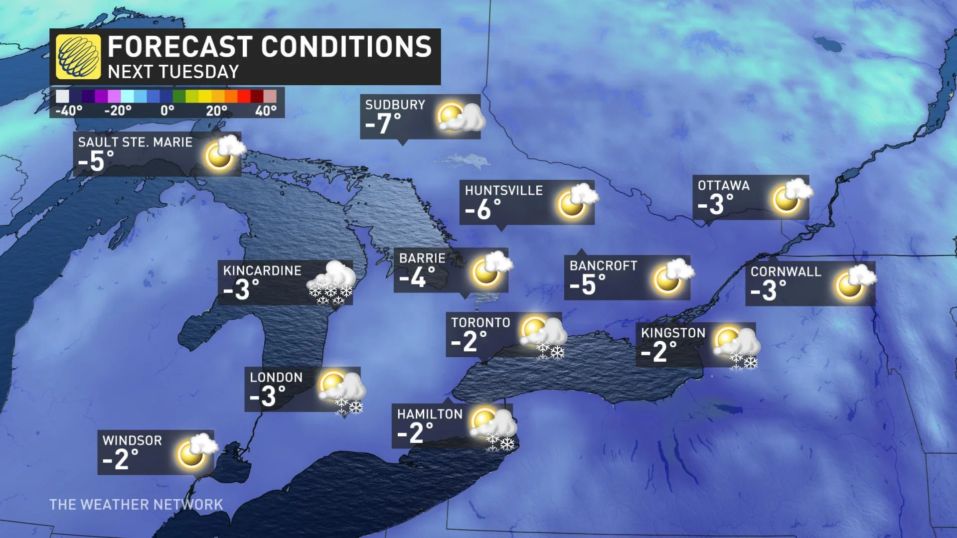
By early next week, temperatures will be feeling much more like mid-December than November, with the struggle even to crack the freezing mark continuing through at least the mid-week mark.


