
Alerts issued in Atlantic Canada as dominant nor'easter will pack wintry wallop
A powerful nor'easter will push Atlantic Canada on Tuesday and Wednesday, bringing heavy snow, rain and intense wind gusts, potentially resulting in difficult travel, power outages and school closures in some areas
December is getting off to a snowy and stormy start for parts of Canada, including the East Coast.
A powerful nor'easter expected to develop Tuesday will take aim for Atlantic Canada that night through Wednesday. A messy mix of rain, 15-30 cm of snow and icy precipitation is forecast with the storm for some areas, along with strong, damaging winds of 70-100 km/h.
DON'T MISS: New colour-coded Canadian weather alerts have now launched. Here's what they mean if you see them
Brace for slippery and hazardous travel or walking conditions. Subsequent rain and snowmelt could lead to water pooling on roads and localized flooding in low-lying areas.
Plan ahead in case schools or scheduled activities are cancelled, and consider adjusting travel plans to avoid the most adverse conditions.
Maritimes to face rain, heavy snow and fierce winds
Forecasters say the conditions necessary for a sharply deepening storm are all present: A strong jet stream, plenty of cold air and unusually warm ocean temperatures to fuel its formation.
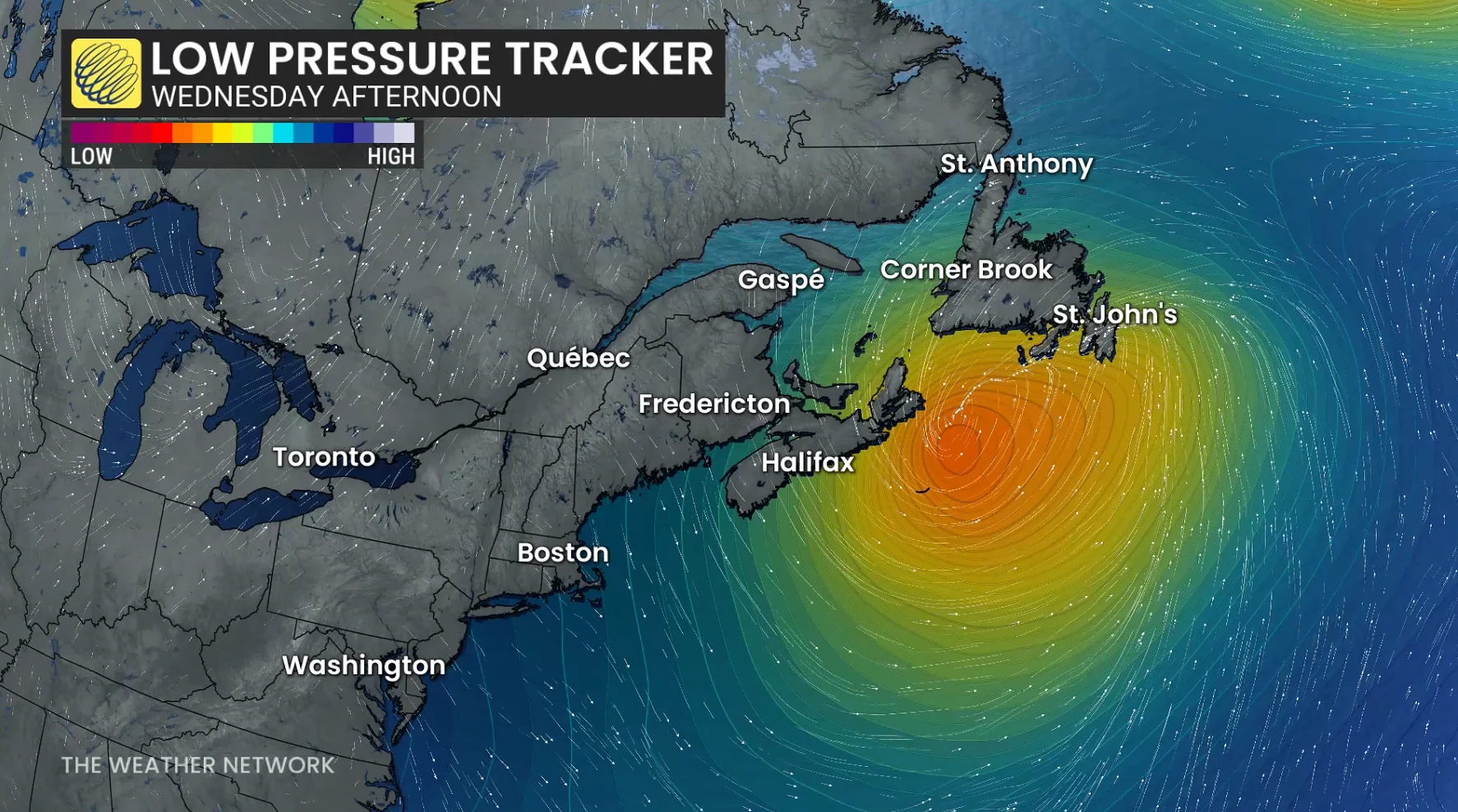
Snow is thought to begin in the Maritimes on Tuesday evening as the low moves along Nova Scotia's south coast overnight. Conditions will continue to worsen into Wednesday morning, with stronger winds and more precipitation.
Southern Nova Scotia is expected to receive the most rain, with over 40 millimetres and wind gusts of 70-90 km/h. Forecasters warn about ponding and pooling on roads.
Cold air will remain in place farther north, including Saint John, Moncton, Charlottetown, the Annapolis Highlands and the Cobequid Mountains. These areas could receive 10-20 centimetres of snow, along with gusts of 50-70 km/h.

Commuters should expect difficult conditions Wednesday morning, with possible delays or closures on the Confederation Bridge.
LOOK: Eco-friendly tips for keeping a healthy pet and planet
WATCH: Tracking a major nor'easter into Newfoundland
Wednesday will be Newfoundland's turn, with snow and strong winds spreading across the island in the morning and intensifying by the afternoon. Snowfall rates could reach 3-5 centimetres an hour, with coastal winds gusting to 90-110 km/h. Inland winds could reach 70-90 km/h.
The combination of heavy snow and strong winds may cause whiteout or near-blizzard conditions, slick roads and the possibility of road, school and business closures. There is also the possibility of localized power outages.
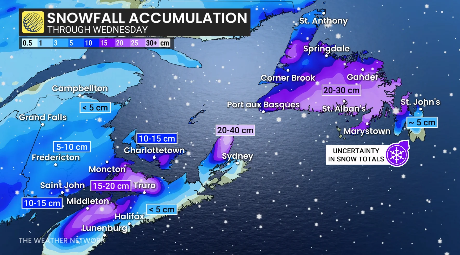
The forecast for southeastern Newfoundland remains somewhat uncertain. The Avalon and Burin peninsulas may see snow turn to ice pellets or rain as the low moves south of the region later Wednesday, potentially affecting snowfall totals.
MUST SEE: A winter storm's track can make or break your forecast
West and central Newfoundland are more likely to remain cold enough for snow, with 15-30 centimetres expected by Thursday morning.
Conditions are anticipated to improve Wednesday night, but cold Arctic air will stay behind the system. On Thursday, wind chill values in some parts of New Brunswick could reach -10 to -20.
WATCH: What to expect from this week's nor'easter in Atlantic Canada
Stay with The Weather Network for the latest across Atlantic Canada.