Potent Prairie storm continues its march eastwards, poor travel in blowing snow

A potent spring system will leave no parts of the Prairies unscathed, as snow and powerful winds continue to push eastwards Tuesday.
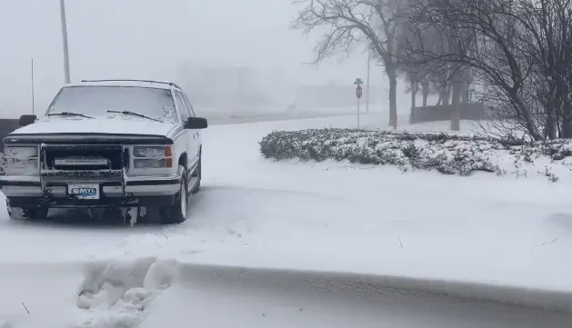
An impactful storm brought blustery winds and dangerous blowing snow conditions to Alberta Monday, leading to a 70-vehicle pileup on the westbound lane of the Trans-Canada Highway between Calgary and Medicine Hat . While conditions have since improved in Alberta, the impactful winds will continue across Saskatchewan and Manitoba on Tuesday, with drivers being urged to avoid any non-essential travel if possible. Snowfall amounts could top 20-40+ cm of snow in parts of Manitoba and northwestern Ontario by the time all is said and done early Wednesday. Following this harsh snap back into winter, much milder weather looks to spread across the Prairies late week, with some southern areas possibly even topping 20 degrees. More on this potent weather whiplash, below.
WEATHER HIGHLIGHTS
Snow continues Tuesday in Saskatchewan and Manitoba
Heaviest snowfall in central Manitoba, northwestern Ontario, with 20-40+ cm of snow, depending on locale
Winds in the 80-100 km/h into Tuesday, will make for hazardous travel on eastern Prairies
TUESDAY: SWATH OF SNOW, POWERFUL WINDS MOVE EAST
Winter returned to the Prairies abruptly Monday thanks to a vigorous low-pressure system and cold front that brought dangerous blowing snow conditions to Alberta and Saskatchewan.
At the height of the storm Monday, more than 14,000 customers in Saskatchewan were left without power, with the howling winds making it unsafe for full restoration efforts.
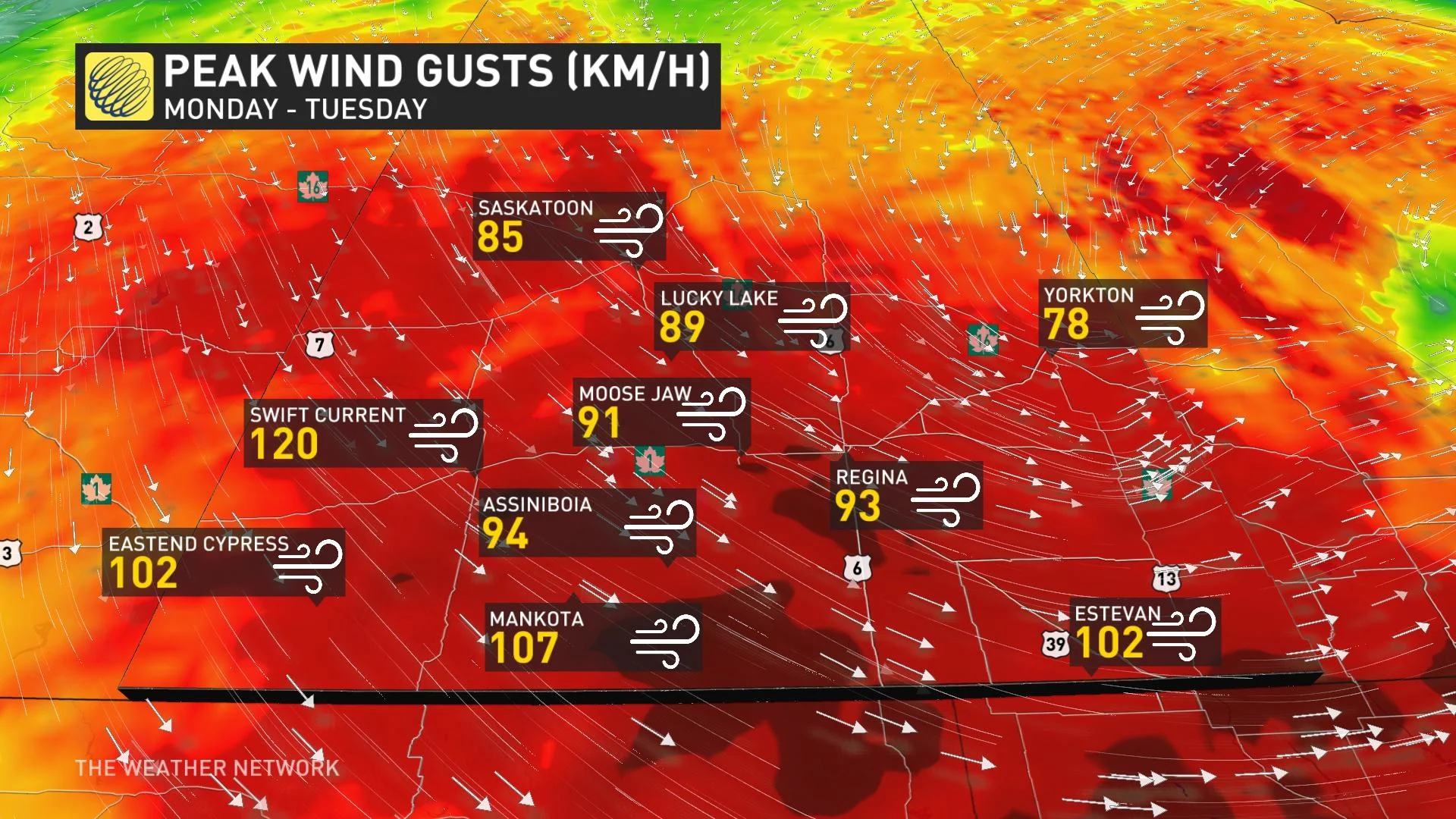
The effects from the storm were still bringing travel chaos to the region early Tuesday, as well, with Highway 1 remaining closed from Moose Jaw to the Alberta border and numerous other highways in western sections of Saskatchewan also closed. At one point Monday night, several drivers were left stranded on Highway 1 as police officials were forced to close all west-bound lanes due to a serious collision.
The potent system will continue its trek eastwards into northwestern Ontario on Tuesday.
MUST SEE: Winter storm slams Alberta, up to 70 vehicles pile up on Trans-Canada Highway
Widespread winter storm and wind warnings were in effect for Manitoba first thing Tuesday, as well as blowing snow advisories warning of hazardous travel and significantly reduced visibilities throughout the day.
Manitoba Hydro reported "several outages" across the province due to the weather conditions soon after the morning commute.
"There are no estimated times for restoration yet, but we're working as quickly and safely as we can," Manitoba Hydro tweeted.

The onset of strong winds will also see temperatures fall quickly, so scattered rain showers will give way to snow during this time. With the winds, visibilities will at times be reduced to 800 metres or less in snow and blowing snow.
The heaviest snowfall amounts still left to come will occur in central Manitoba and northwestern Ontario as the storm continues its march east. More than 40 cm of snow could fall along a section of the northern Manitoba and northwestern Ontario border, while 30-40 cm could fall in central Manitoba.
Winds will be much quieter in Alberta and western Saskatchewan Tuesday, but eastern sections of the latter will see gusts in the 70-80 km/h range continue through the morning.
The focus of the strongest wind gusts will be in Manitoba Tuesday, where the south could see gusts of 80-90 km/h.
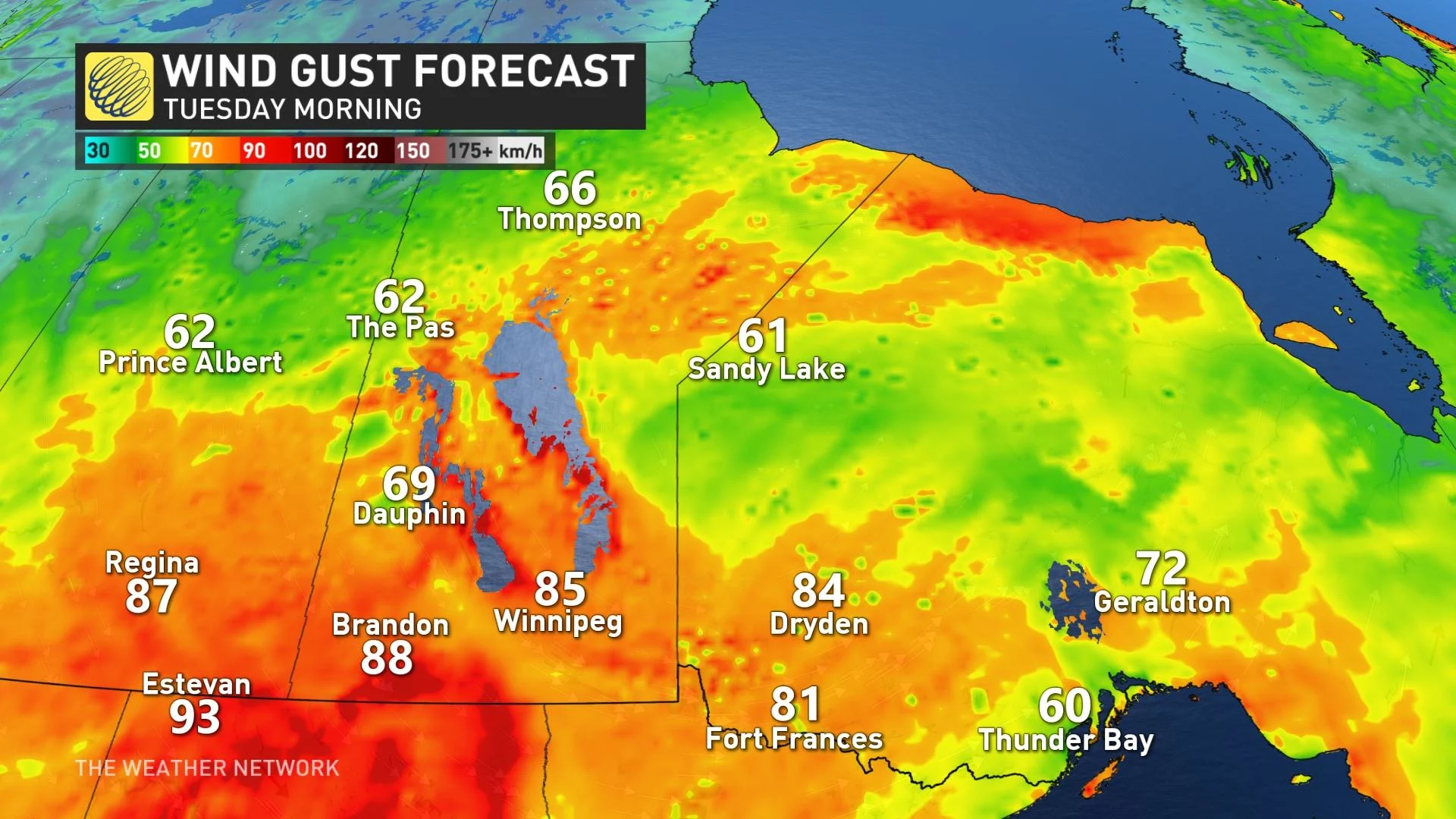
Snow is expected to depart Saskatchewan and Manitoba by early Tuesday afternoon, but blowing snow will linger through the day as winds remain strong. Environment Canada warns that motorists will still need to proceed with caution on the roads.
WATCH BELOW: FROM GRASSFIRES TO BLIZZARDS, THE PRAIRIES EXPERIENCED WEATHER WHIPLASH!
SOARING BACK INTO THE 20S BY WEEK'S END?
Beyond, after a quick shot of wintry weather, much milder weather will spread across the Prairies through the late week mark, with temperatures in the mid-to-upper teens, possibly even topping 20°C in a few spots across southern areas.
Closer to seasonal temperatures will settle in for the weekend. No major storms are expected after this current system, with mostly quiet conditions persisting through the weekend.
Thumbnail photo credit: Jenny Hagan, Saskatchewan.
Check back as we continue to monitor the dangerous impacts from this system.


