Lee's damaging winds, rain, surge continue as storm hits Maritimes

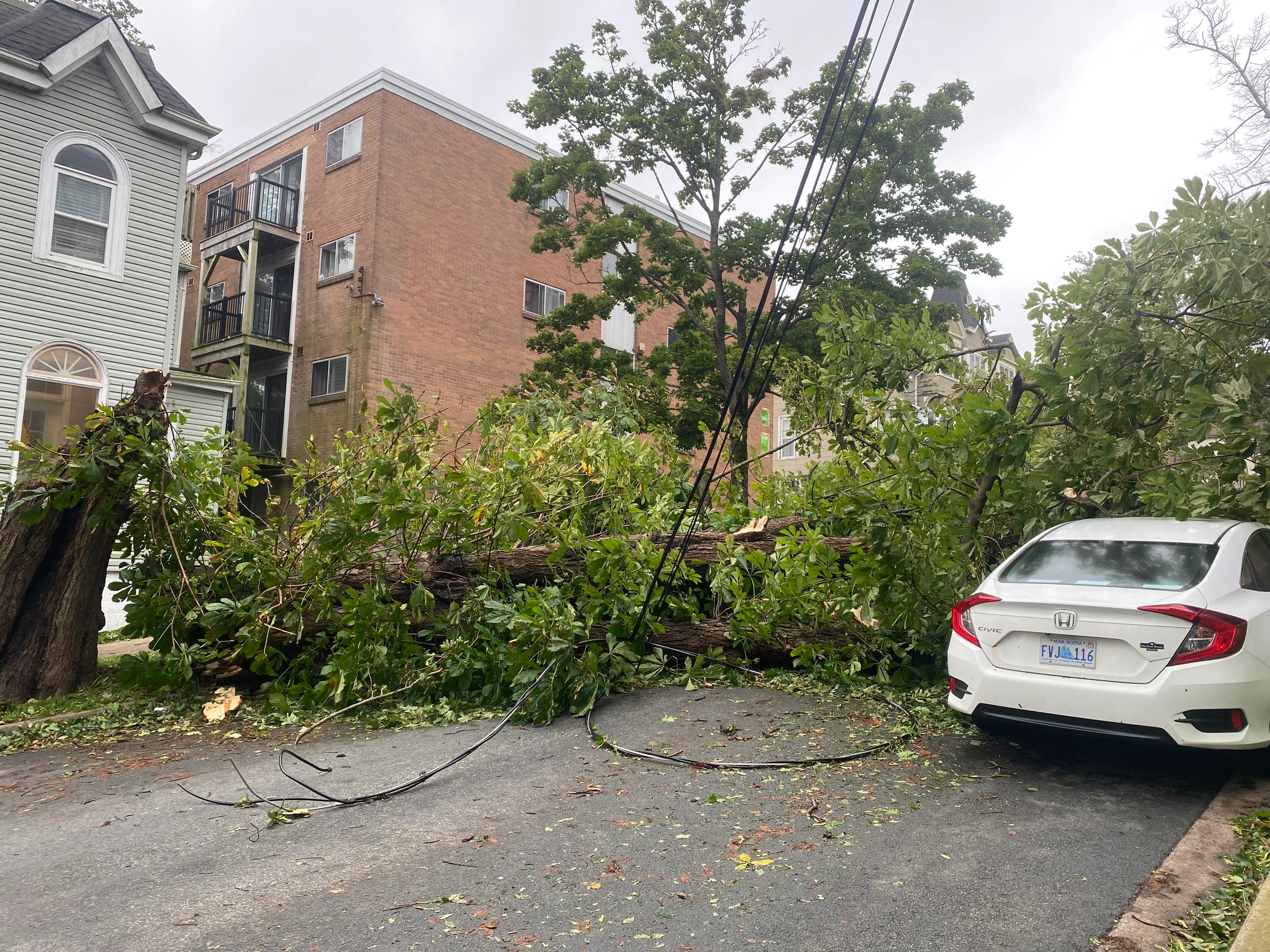
Widespread power outages continue as Lee hits the Maritimes on Saturday. Downed trees, heavy rains, coastal flooding, road closures, ferry cancellations, and one injury have all been reported
Visit The Weather Network's hurricane hub to keep up with the latest on tropical developments in Canada and around the world
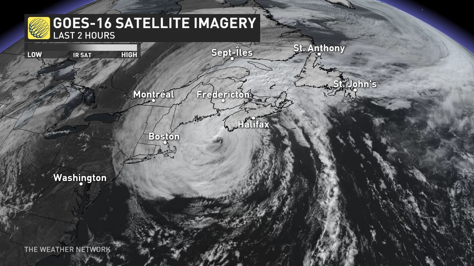
Lee continues to lash the Maritimes on Saturday as the powerful system steadily pushes across the region.
High winds, heavy rain, and coastal flooding have caused significant issues for portions of Nova Scotia and New Brunswick, with hundreds of thousands of power outages reported and road closures as a result of standing water and fallen trees.
The storm’s hazardous conditions will peak on Saturday before waning through the overnight hours into Sunday. A risk for additional power outages and flooding will persist for the duration of the storm.
RELATED: PHOTOS: Powerful Lee leaves impactful mark on the Maritimes, one injured
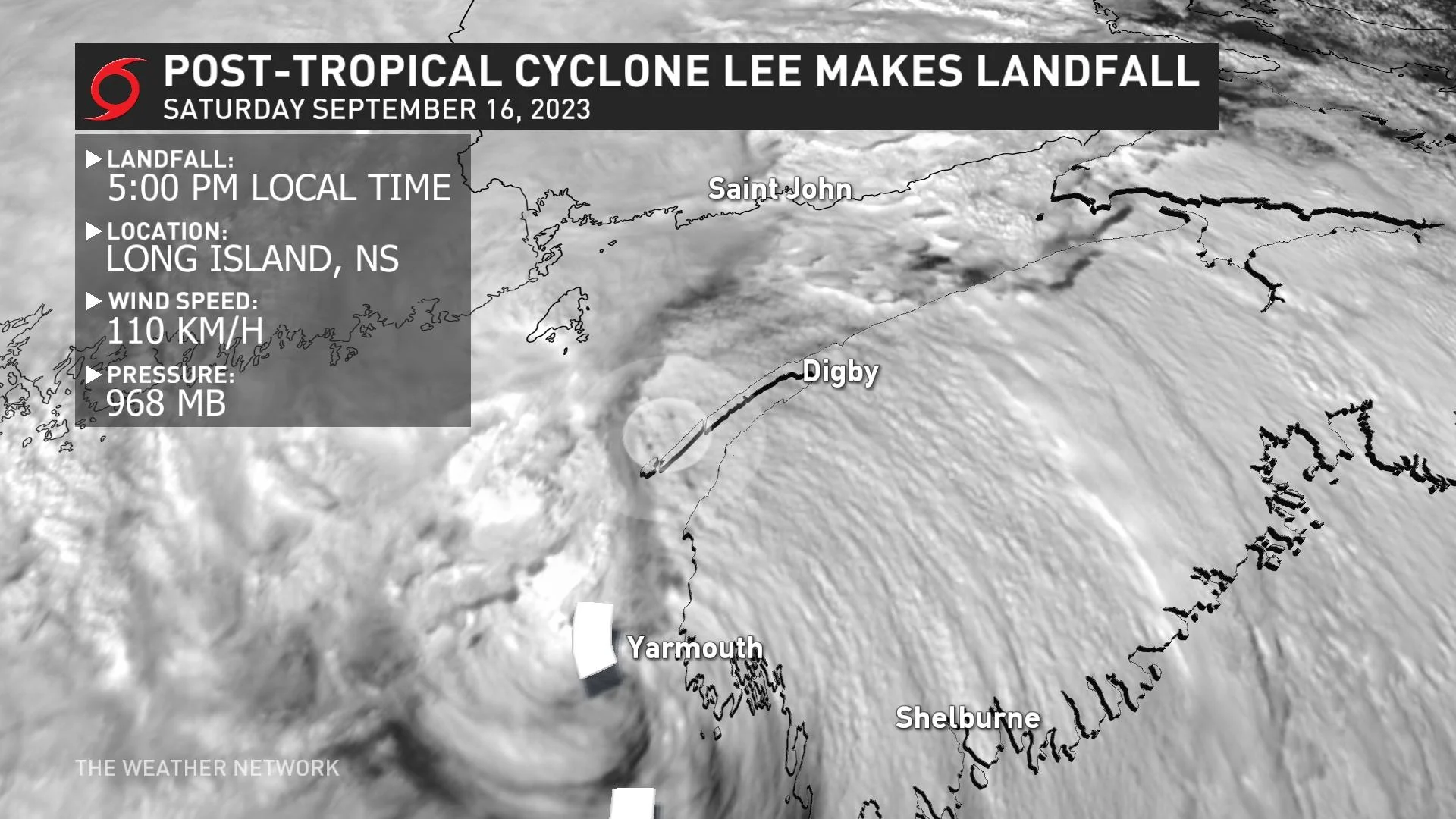
The centre of post-tropical storm Lee officially made landfall on Long Island in extreme southwestern Nova Scotia at 5:00 p.m. local time, according to the U.S. National Hurricane Center (NHC). Lee's centre will move over the Bay of Fundy and make a second landfall in New Brunswick later Saturday evening.

Around 120,000 customers remained without power in Nova Scotia by 8:30 p.m. local time on Saturday, while nearly 20,000 customers were without power at the same time in New Brunswick. Maritime Electric reported several thousand customers without power on Prince Edward Island as the winds picked up there through the afternoon and evening.
Numerous flights, events, and ferry crossings have been cancelled across the Maritimes. Peggy’s Cove also remained closed to the public due to the hazardous conditions.
Multiple road closures have been reported throughout Nova Scotia and New Brunswick as a result of standing water and fallen trees. One injury was also reported as a result of the storm. A motorist suffered non-life-threatening injuries when a pine tree fell on his vehicle while he was driving into Blockhouse, N.S., reported by CBC News. His injuries were not life-threatening.
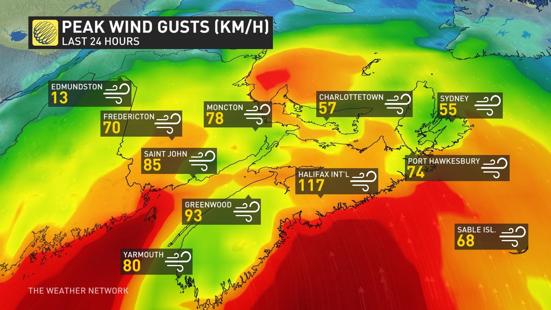
There was a reported wind gust of 117 km/h at Halifax airport Saturday morning.
WATCH: House shifted off its foundation as Lee hits Peggy's Cove
Lee is expected to be at or just below hurricane strength when it makes landfall today. Weakening is forecast tonight and Sunday while Lee moves across Atlantic Canada.
A threat for heavy rains, high winds, and coastal flooding will continue to extend hundreds of kilometres from the centre of the storm. The biggest concerns will be dangerous surf and coastal flooding, especially during the next high tide cycle Saturday evening.
As a result of these potential hazards, there are widespread alerts in effect throughout the Maritimes.
The Canadian Hurricane Centre (CHC) issued tropical storm warnings for parts of Nova Scotia, New Brunswick and P.E.I.
In addition to the tropical storm warnings, a hurricane watch is in effect for parts of the aforementioned provinces. These areas could see the potential for near-hurricane conditions during the height of the storm on Saturday.
Click here to stay up-to-date with the latest watches and warnings.
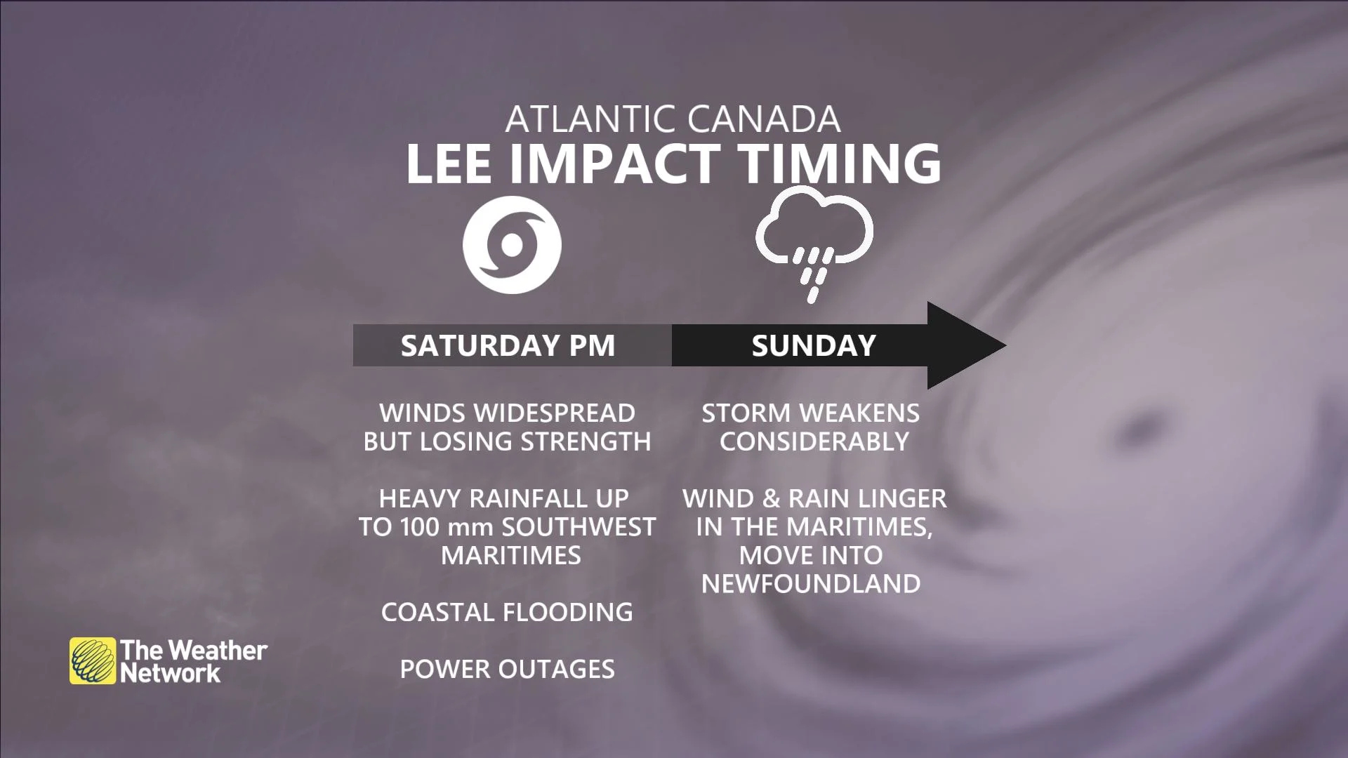
Strongest impacts expected Saturday
While the worst conditions are expected across the Maritimes through Saturday, lingering impacts are expected into Sunday as the storm weakens and moves away.

Rain
Between 60-100 mm of rain is possible in the southern Maritimes over the weekend. The risk for flooding has increased over western Nova Scotia and the Annapolis Valley.
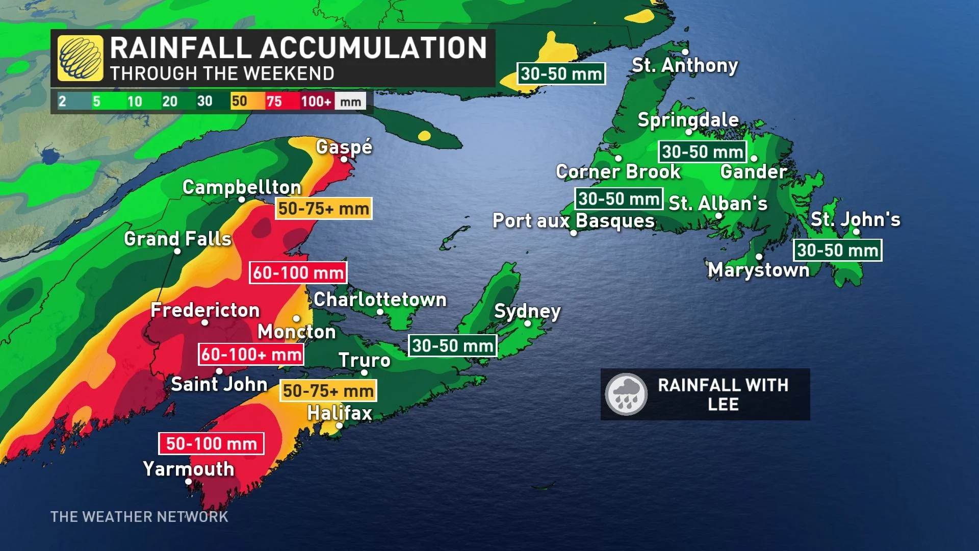
"There could be heavy amounts in the vicinity of the track itself with indications of possibly 75 mm directly from Lee," the CHC warns. "This combined with the rain that fell there Thursday increases the vulnerability to further flooding in that area."
Wind
At the same time, winds will peak on Saturday, with gusts of 70-100 km/h expected. Communities along the coast can expect the storm’s strongest winds, with wind speeds quickly decreasing inland.
Areas under the hurricane watch will likely see the strongest winds, with gusts as high as 120 km/h possible at times. These winds would typically result in some tree damage and power outages, especially as trees still have their leaves.
Gusty winds are still possible Sunday even as conditions improve.
WATCH: VIDEO: Lee starts the day in Nova Scotia with strong winds and rough waves
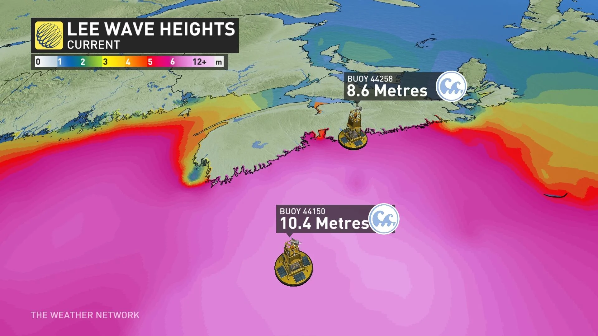
Storm surge
High waves and elevated water levels are widespread due to the large size of the storm. Rough waves and storm surge flooding will pose the greatest threat to coastal communities on the Bay of Fundy shores and the southwest coast of Nova Scotia.
A storm surge warning has been issued for Halifax Metro and Halifax County West, Halifax County - East of Porters Lake, Lunenburg County, Queens County, Shelburne County, Guysborough County. People near the coast are being urged to monitor for worsening conditions and be prepared to move to a safer location at a moment's notice.
"For Atlantic coastal Nova Scotia, breaking waves of 4-6 metres (15 to 20 feet) are likely," says the CHC. "Elevated water levels (storm surge) combined with waves could result in coastal flooding during the high tide late morning to noon Saturday in Shelburne County then during the high tide late Saturday evening along the coast from Queens County to eastern Halifax County."
A storm surge of 0.72 m was reported in Halifax Harbour at high tide Saturday morning. Additional coastal flooding is possible across the Maritimes for the duration of the storm, especially during the next high tide Saturday evening.
Stay with The Weather Network for the duration of this storm as we closely monitor this hurricane and its developments.
Thumbnail courtesy of Lisa Weir/Facebook, taken in Saint John, N.B.