Snow squalls create hazardous travel in Ontario, frigid air ushers in

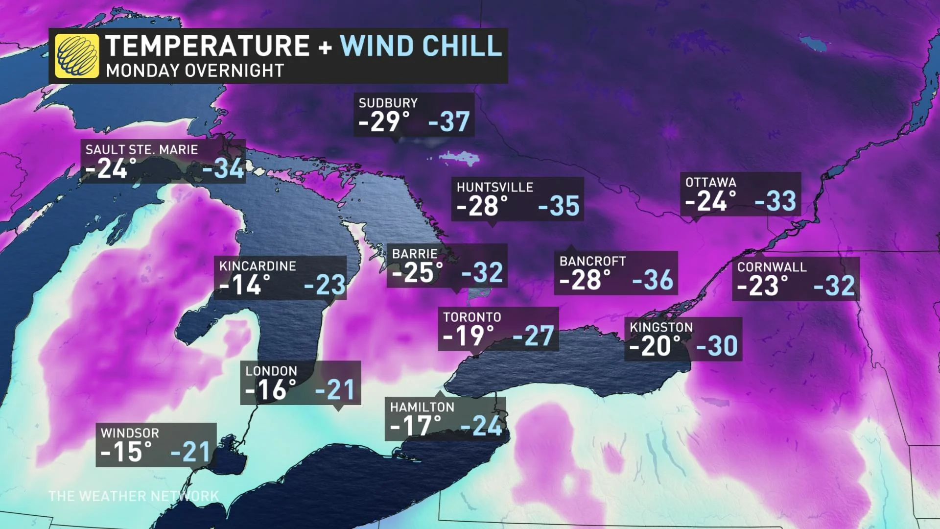
Bundle up, as wind chill values dip into the -20s to -40s across Ontario Monday overnight, with snow squalls bringing hazardous travel and threatening 15-30+ cm in some locations.
The week kicked off on a stormy note across parts of southern Ontario, with the lake-effect machine sparking off bands of potent squalls near Georgian Bay and Lake Huron, resulting in dangerous travel in these areas. The squalls will continue to drift Monday overnight, so commuting will remain difficult, easing by Tuesday morning as winds diminish and begin to shift. Snowfall totals may exceed 15-30+ cm in some locations. Not only that, but the region's coldest temperatures of the season are en route. Arctic air, combined with light winds, will bring extremely cold temperatures and wind chills to the region Monday overnight into Tuesday morning. Extreme cold warnings are in place. More on the persisting snow squalls and how cold it will be into Tuesday morning, below.
DON'T MISS: Flip the switch: Western Canada warms up as polar vortex shifts east
THIS WEEK: SNOW SQUALLS TO EASE TUESDAY, COLDEST AIR OF THE SEASON ARRIVES
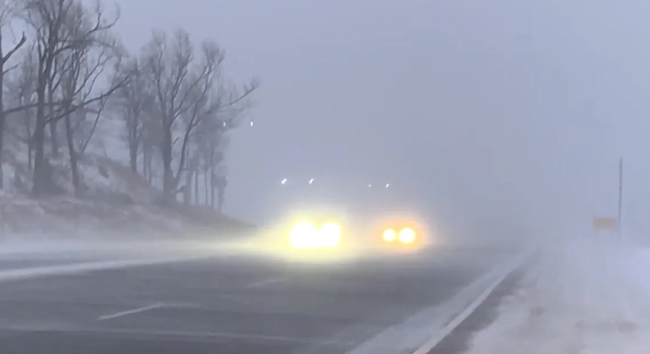
A rather strong cold front that ushered in frigid Arctic air to Ontario also set off potent snow squalls to start the week. Travel was certainly hampered Monday in many locales near Lake Huron and Georgian Bay. As a result of the treacherous conditions, some roadways were closed and at least one accident was reported on the southbound lane of Highway 400.
Snow squalls will continue through Monday overnight then slowly taper off to flurries Tuesday morning as the winds diminish and shift directions.
Conditions will remain deteriorated and localized whiteouts will continue to bring some treacherous travel on major routes and highways.
"Visibility will be suddenly reduced to near zero at times in heavy snow and blowing snow. If visibility is reduced while driving, slow down, watch for tail lights ahead and be prepared to stop," says Environment and Climate Change Canada (ECCC) in the snow squall warning. "Rapidly accumulating snow could make travel difficult over some locations. Consider postponing non-essential travel until conditions improve."
Areas near Lake Huron and Georgian Bay will see the heaviest snow, with accumulations of 15-30+ cm through Tuesday possible. Winds will remain blustery overnight, with 50-70 km/h gusts lingering, but will subside through early Tuesday morning. The strongest gusts will be along the lake shores
Some of these snow bands that have drifted across parts of the GTA will move out Monday overnight.
COLDEST AIR IN YEARS SPANS THE SOUTH
Some of the coldest weather of the season floods into southern Ontario to start this week, particularly Monday overnight into Tuesday morning. Extreme cold warnings are in effect.
Overnight lows are set to approach -20°C, dipping well into the -20s for areas north and east of the GTA. This would actually be the first -20°C temperature in almost two years for the city of Toronto. February 14, 2020 was the last time the city reached a low of -20.6°C

Wind chills will improve Tuesday morning after sunrise. High temperatures will only be near the -20s on Tuesday for Ottawa, with overnight lows reaching the -30s outside of urban areas.
"However, this will be a quick shot of frigid weather as temperatures will quickly rebound back to near or above seasonal — above freezing for southern Ontario — Wednesday and Thursday," says Dr. Doug Gillham, a meteorologist at The Weather Network.
That's as winds shift directions out of the southwest, really helping to warm things up and break apart the snow squall activity.

Beyond, no major storms in sight, yet, but will keep an eye on a system that is expected to track well south of the border this weekend. Forecast track at this point is much too far south to have a direct impact on the region, but we could have a cold easterly flow off Lake Ontario -- bringing the potential for a band of lake-effect snow near the west end of the lake.
A wintry pattern is expected for next week and into the following week, with temperatures near seasona or on the cold side of seasonal much of the time, and the potential for the pattern to become more active or at least more typical of the season at this point.
Be sure to check back for the latest weather conditions in Ontario.


