
Over 100 mm of rain coming to parts of B.C., landslide potential for some

A very rainy period is ahead for B.C., forecasters say there will be breaks here and there, so it won't be a continuous deluge.
The best days for outdoor activities will be Monday and Thursday for many folks in British Columbia due to an unsettled trend lingering in the region this week. Storm after storm will track through the province and some regions could see over 100 mm of rain by Wednesday. While Monday will be mostly calm, the precipitation will pick up in the evening and through the overnight hours as a potent Pacific low pressure system targets the region. Details and timing, below.
WEATHER HIGHLIGHTS
Next several days will feature precipitation, though with scattered dry breaks
Risk of localized flooding, landslides in areas seeing potential for heavy rain
Temperatures stable at 5-8°C for the coast
Visit our Complete Guide to Winter 2021 for an in depth look at the Winter Forecast, Canada's ski season, and tips to plan for everything ahead!
MONDAY: BRIEF BREAK BEFORE THE NEXT ROUND OF RAIN
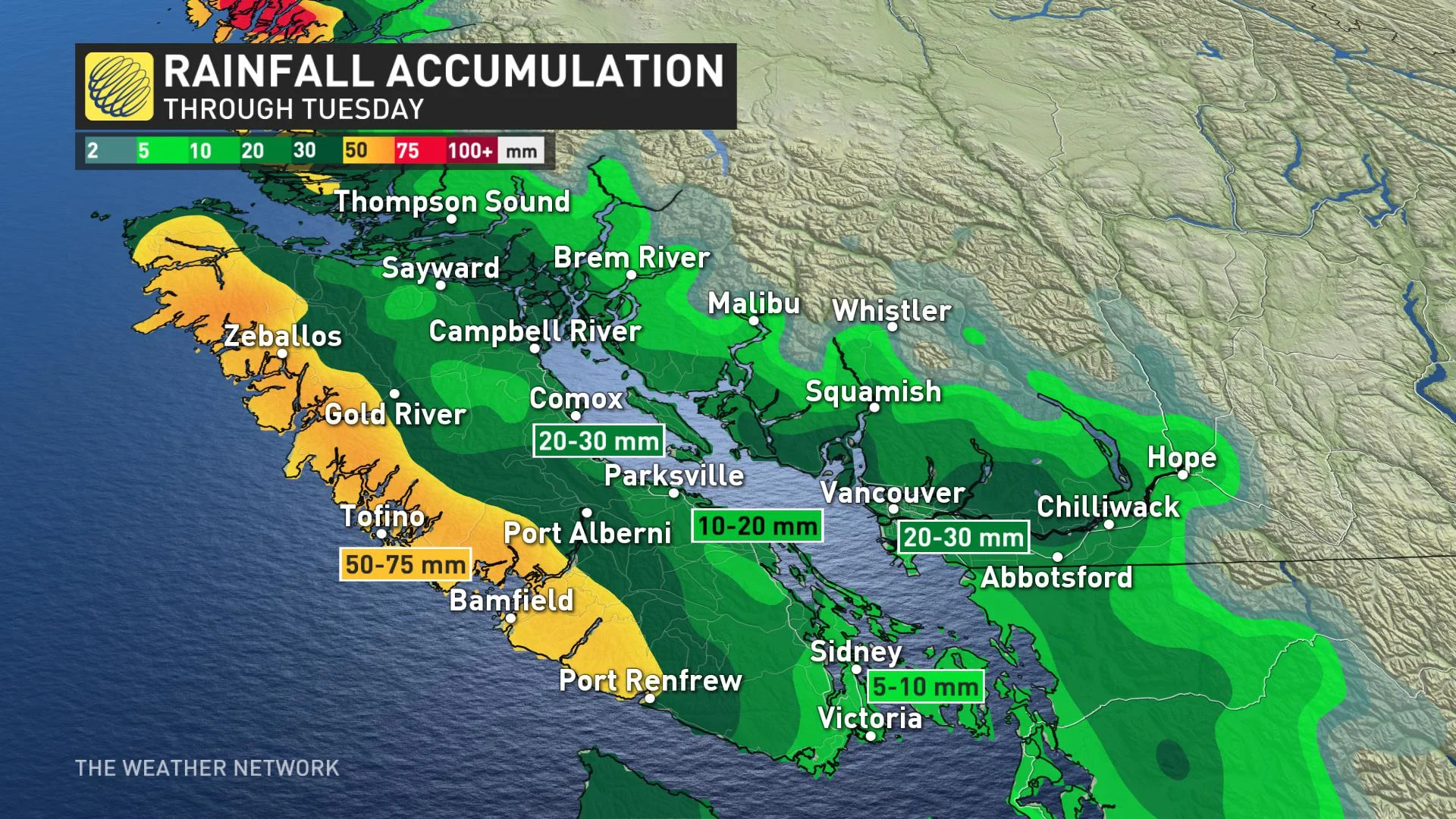
The rain that began on Sunday will gradually diminish by Monday morning, providing a brief break before the next front pushes onshore in the overnight hours, again bringing soggy weather for the coast and Lower Mainland and another round of alpine snow. Through Monday morning, about 10-20 mm is expected for the Lower Mainland and western Vancouver Island.
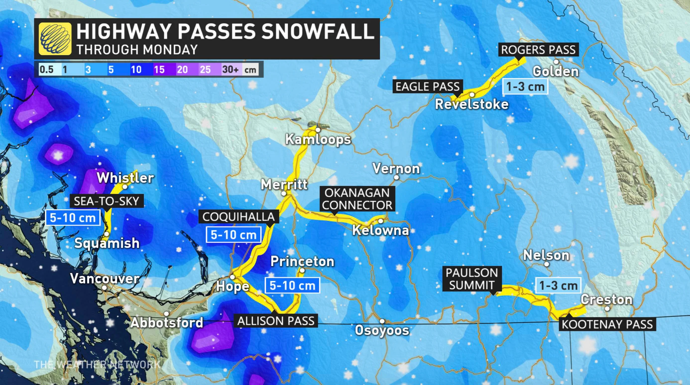
Freezing levels will be around 700 metres on Monday, meaning snow in the mountain passes and similar elevations. The levels will hover around the 1000-metre mark until Wednesday, rising slightly before dropping back to 1000 metres. Through Monday, some of the highway passes may see 5-10 cm of snow.
On Vancouver Island, areas near the coasts may see a few flakes here and there, but little in the way of accumulation, while early-morning snow is likely at elevations.
BEYOND: RISK OF LOCALIZED FLOODING, LANDSLIDES
British Columbia will see a multi-day stretch of wet conditions as system after system impacts the province. The unsettled weather continues through mid-week.
Tuesday will see steady rains and alpine snow continue. In fact, significant snow is possible for the southern interior on Tuesday.
By Wednesday, amounts in the 75-100 mm range are in store for coastal areas, while the Lower Mainland will see 30-50 mm of rain. Some areas of western Vancouver Island, including Tofino, could see upwards of 150 mm of rain this week. The Weather Network meteorologist Tyler Hamilton says that localized flooding and the potential for landslides are possible this week in areas that are seeing significant amounts of rainfall.
In the alpine areas, an abundance of snow is likely, with half a metre or more possible in some areas, though a changeover to rain is possible later this week as some of the storms will bring milder air.
Hamiltons says that powerful wind gusts will impact the South Coast on Wednesday evening and could reach warning criteria.
Check back as we continue to monitor the forecast for B.C.