
Fair shot at hitting the 20-degree mark in parts of southern Ontario

Pacific air arrives in southern Ontario Wednesday, resulting in above seasonal temperatures for the next two days before they drop in time for the weekend -- accompanied by the return of messy, wintry weather.
After sneaky snow swept through a narrow part of southern Ontario Tuesday, conditions will greatly improve Wednesday as the region welcomes in milder air. It won't be completey rosy for everyone, with an easterly wind preventing areas along the lakeshores from warming up to the double digits. By St. Patrick's Day, double-digit temperatures will be more widespread, giving a couple locales in the southwest a chance at cracking the 20-degree mark even.
Visit our Complete Guide to Spring 2022 for an in-depth look at the Spring Forecast, tips to plan for it and much more!
But, don't let your guards down. Wintry weather can often and will likely continue at times in the spring season, so keep your scarves, toques, gloves and shovels handy. Meanwhile, forecasters are keeping a close eye on a more potent system arriving by the weekend, giving some another wintry shot before the officil start of spring.
Tuesday: Blast of sneaky snow hits Ontario's busiest area
An influx of milder Pacific air has been slowly making its way across the country this week, as high pressure builds over Eastern Canada.
We will begin to really feel the warmth on Wednesday. A wide range in temperatures with mid- and upper teens for southwestern Ontario, but slightly cooler (mid- and upper single digits) in the Greater Toronto Area (GTA).
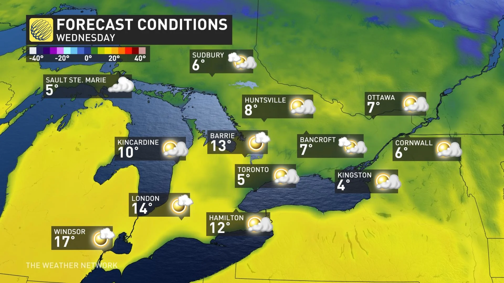
Communities close to the lakeshores could find some disappointment, however, with temperatures lower than readings from inland locations. This is thanks to the easterly wind that will prevent temperatures from climbing, with as much as a six- to eight-degree difference between shoreline and inland areas.
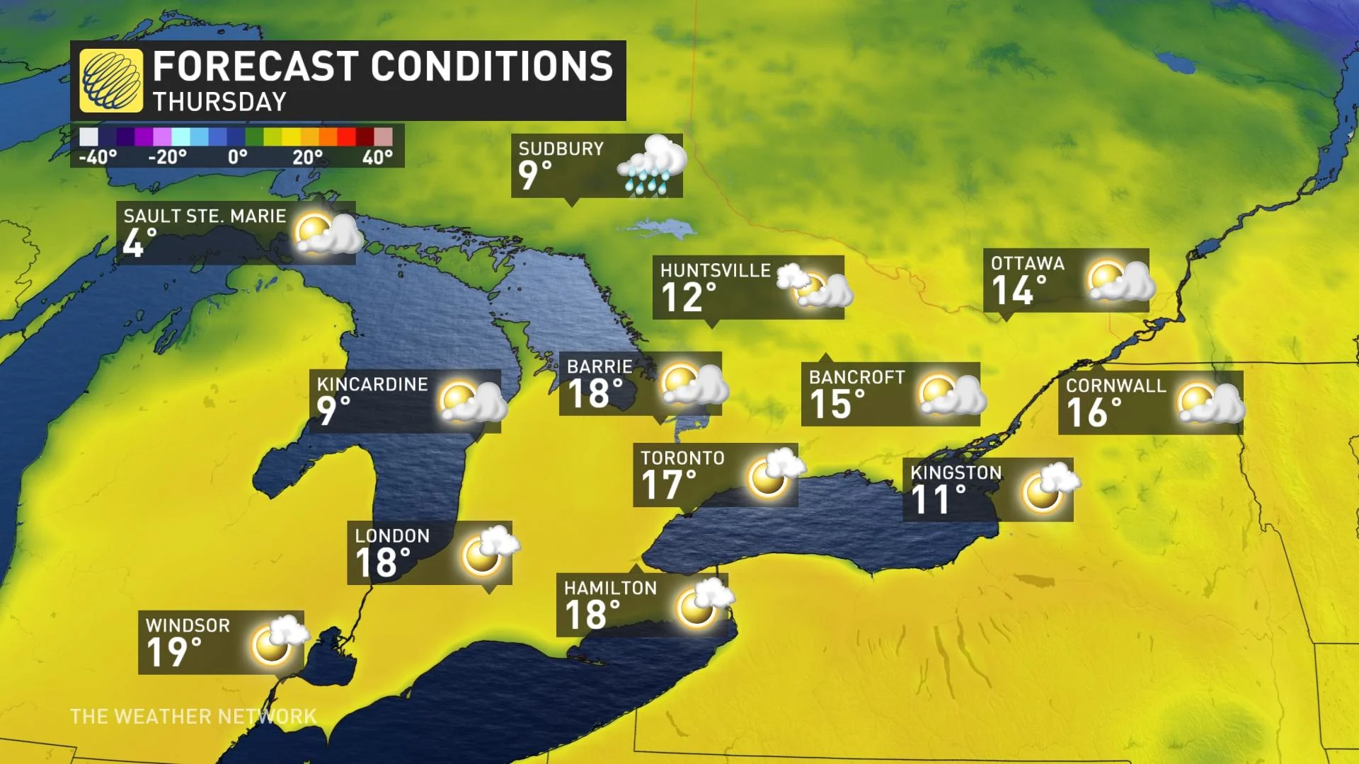
We'll then see temperatures more consistent with late April or early May by Thursday.
Highs on Thursday could easily reach 15°C-19°C across a good chunk of southern Ontario. For context, the seasonal daytime high is around 4°C with an overnight low of -4°C.
"For some, this will be the warmest St. Patrick's Day in over 10 years," says Kelly Sonnenburg, a meteorologist at The Weather Network.
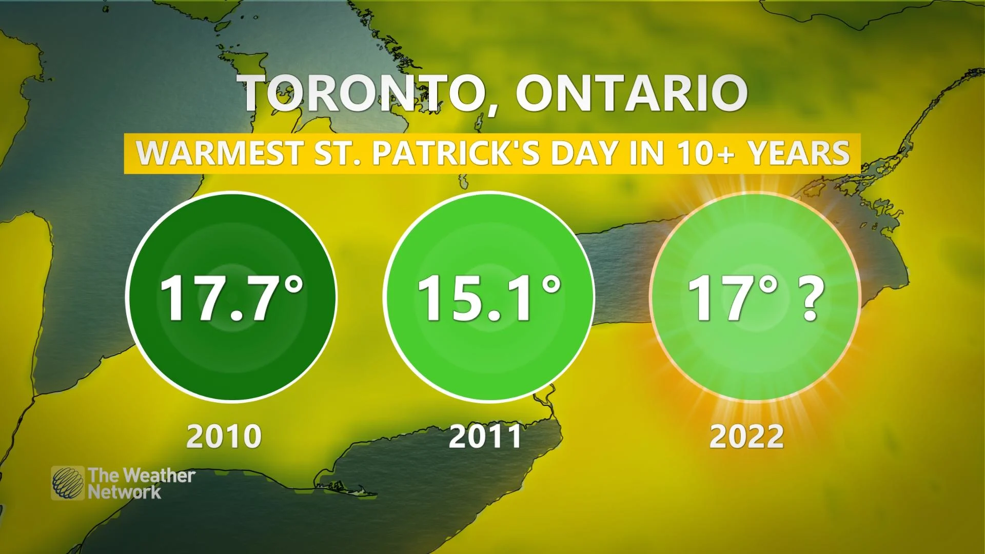
Toronto is currently forecast to hit 17°C, and we'd have to go back to St. Patrick's Day of 2011 and 2010 when the temperatures reached 15.1°C and 17.7°C, respectively. This would also be Toronto's first double-digit daytime high on March 17 since 2016.
"Will this be the warmest St. Patrick's Day ever though? Likely not," Sonnenburg says. "Toronto's Pearson airport reached 19.4°C back in 1945, and more recent, 18.6°C in 2003."
For communities such as North Bay and Barrie, Ont., it's also been about 10 years since they saw double-digit warmth on St. Patrick's Day.
Conditions will still remain warmer than seasonal even in areas influenced by the cooler waters. Some areas across the southwest may even see daytime highs near the 20-degree mark.
Temperatures are expected to dip closer to seasonal by the weekend, greeted by a Texas low that will bring widespread rain for the south and potentially significant wet snow along the northern edge of the storm.
"Don't get too comfortable as Mother Nature could bring another taste of winter weather, with a chance for some snow to wrap up the final day of winter 2022 this weekend," adds Sonnenburg.
Fair and mild weather is expected to return for Sunday and early next week. Above seasonal temperatures through mid-week but another Texas low is expected to bring widespread rain.
Also watching the potential for a colder pattern to return for the final few days of March. April is expected to test our patience at times with periods of colder weather.
Stay tuned to The Weather Network for the latest forecast in Ontario.