Blame the jet stream for sombre start to the new year in B.C.

A stagnant jet stream brings even more rain to British Columbia over the next several days, making any sunshine obsolete.
For many in British Columbia, the new year has started on a rather wet and gloomy note, weather-wise. Unfortunately, this trend will be sticking around for a little bit longer as more rain and wind is in the forecast for the next several days. But don’t worry, there is (sun)light at the end of this tunnel.
On Thursday, Environment and Climate Change Canada (ECCC) had issued wind warnings for much of the southern coastal regions of B.C. as a strong low-pressure system that has caused death and destruction in California moved its way north along the coast. Luckily for B.C., the system weakened as it moved north, although it still brought heavy rain and high winds with it. ECCC has since lifted the warnings.
SEE ALSO: California lashed by deadly 'atmospheric river' storm
Some may be wondering what has been causing all of this rain in B.C. and extreme weather south of the border to happen. The answer for this is fairly simple – the jet stream.

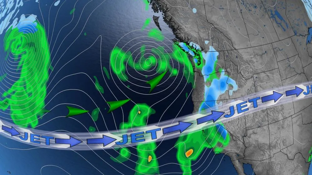
The jet stream is what dictates global weather patterns. It is typically described as being one of two patterns: meridional (wavy) or zonal (straight). Like all weather patterns, jet streams are dynamic; they are always changing and varying in shape and strength.
Currently, this winter jet stream is in a zonal pattern over the Northern Hemisphere and will be for a while yet. On top of that, it is positioned slightly farther south than it would typically be. It is also carrying moisture from southeast Asia, which when met with a powerful low-pressure system and mountainous terrain, creates the extreme weather we have been witnessing in California and prolonged rain in B.C.

MUST SEE: Super-straight jet stream will cause localized weather chaos worldwide
Other than the event on the West Coast, a straight and stagnant jet stream typically drives more frequent but smaller weather systems, as well as seasonal or above-seasonal temperatures, which we have been seeing in Canada.
For the coastal regions of B.C. this all means that the wet pattern residents have been experiencing over the last couple of weeks will not be letting up any time soon over the next several days. Over a half-dozen more systems will move into the region, bringing with them light to moderate rain, breezy winds, and cloudy skies.

In the week following that, conditions are not expected to improve much as the wet pattern is forecast to continue. However, this will make the sight of sunshine all the more better in the later half of the month as conditions begin to improve, reminding us all that the sun will always shine again.
Keep checking backfor more forecast updates on the weather in B.C.


