Storm track stays zoned in on Atlantic Canada with more wintry messes

No break for the storm-fatigued Atlantic Canada as the next system has arrived already, delivering strong winds and another round of rain, snow and potential flooding that will just pile on top of the previous wintry mess across the region.
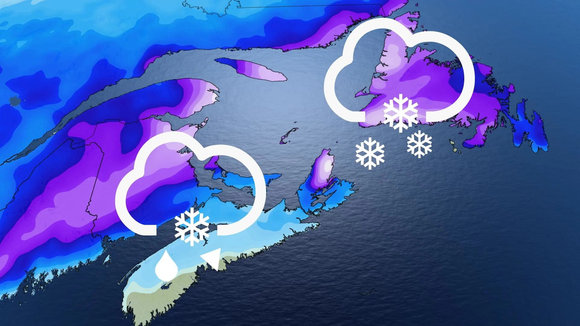
An active boundary continues to sit across Atlantic Canada, bringing in another round of stormy weather. The region can't catch a break after several weekends of wintry weather this year, with parts of the Maritimes still dealing with the power outages from the most recent storm. The new system won’t be as severe for many, though, but the added snow, heavy rain, intense winds and risk for localized flooding will lead to headaches through Wednesday. Travel is likely to be impacted by areas that see heavy snow and strong winds, especially. Rain, snowfall, wind and winter storm warnings are in place across the region. More on what to expect over the next couple of days, below.
PHOTOS: Widespread Atlantic power outages after major ice, heavy snow
MONDAY NIGHT INTO TUESDAY: RAINY, SNOWY SYSTEM ARRIVES IN MARITIMES
A low-pressure system that developed off the U.S. East Coast began pushing precipitation into the Maritime provinces Monday evening, and will persist through Tuesday. Rain, snowfall, wind and winter storm warnings are in place across the region.
Snow has already moved into New Brunswick, where temperatures are hovering below the freezing mark. In Nova Scotia, we could see a few flurries before rain moves in throughout the overnight hours, continuing into Tuesday evening.

Areas south of Frediction, N.B., could see a prolonged period of a wintry mix, prompting low snowfall totals. Widespread snow will then spread across New Brunswick and P.E.I. Tuesday morning.
As we head into the afternoon hours, then we shall start to see heavier rain move in across Nova Scotia and southern New Brunswick, with snow in place for the higher terrrain in Cape Breton.
Snowfall totals in the Maritimes will be greatest in central and northern New Brunswick, where 15-40 cm is possible through Wednesday. Parts of eastern Nova Scotia will also be on the hook for 20-40 cm, as well. Rapidly accumulating snow could make travel difficult over some locations.

Many communities across New Brunswick and P.E.I. have 30-60+ cm of snow on the ground, with Moncton coming in at a whopping snow depth of 110 cm. Any rain that falls on this thick snowpack will carry the risk for localized ponding and flooding issues. Rainwater runoff simply won’t have anywhere to go.
Besides the rain and snow, winds will be a concern for the Maritimes. Winds will ramp up in Nova Scotia Tuesday afternoon into evening as the centre of the low moves across, with gusts of 50-70 km/h.
Heavy rain continues for Nova Scotia before tapering off in the late evening hours Tuesday, while light snow persists in New Brunswick and P.E.I. during this time. The system moves out of the Maritimes by late Wednesday morning.
TUESDAY NIGHT INTO WEDNESDAY: SNOW SPREADS OVER NEWFOUNDLAND
Meanwhile, across the Gulf, light snow will continue across Newfoundland into Tuesday afternoon. As the low moves in closer, thats when we will start to see heavy snow spread across the island.
We have a decent shot at adding more snow on top of what’s already fallen across the island. Like the Maritimes, central Newfoundland has a respectable snowpack from the recent spate of storms.

Snowfall amounts for Newfoundland will be excessive for western and northern areas, where 15-40 cm could fall through Wednesday. The Avalon is going to get in on the snow, as well, with 5-15 cm possible for the peninsula before the changeover to rain on Wednesday.
"Consider postponing non-essential travel until conditions improve. Visibility will be suddenly reduced to near zero at times in heavy snow and blowing snow," Environment and Climate Change Canada (ECCC) says in the warning.
Similar to the Maritimes, the island will see blustery winds develop from Tuesday overnight to Wednesday afternoon, with gusts of 70-90 km/h.
The system will be exiting Newfoundland by Wednesday evening.
Looking ahead to the rest of the week, we should see calmer conditions and a stretch of above-seasonal temperatures as we work toward the weekend.
Check back for the latest on conditions across Atlantic Canada.