Ontario wakes to major Tuesday snow, widespread school closures

Dangerous winter storm wallops Ontario early Tuesday, eyes already shift to the next snowy blast this week.
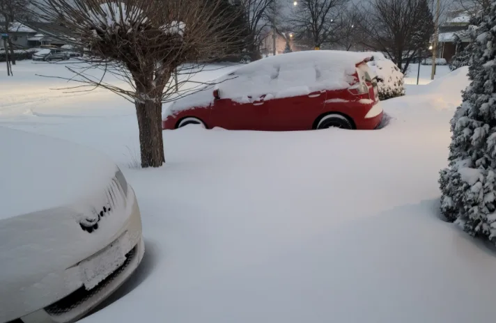
Winter warnings are gradually dropping across parts of Ontario after a potent storm ramped up in intensity through the overnight hours on Monday and pushed heavy snow into the region Tuesday morning. Drivers are still being warned to postpone any non-essential travel until conditions improve, with very poor visibility reported in areas of blowing snow. A widespread 15-30 cm of snow is forecast across the region before it eventually tapers Tuesday afternoon, combined with wind gusts of 50+ km/h, making for dangerous conditions on many major routes. Several school boards across the province cancelled buses and closed schools, while some students remained learning remotely from home instead. More on the timing and impact from this latest winter's blast, plus a look at yet another storm that follows hot on its heels on Thursday, below.
WEATHER HIGHLIGHTS
Winter warnings linger for parts of southern and eastern Ontario for heavy snow, strong winds impacting the region through Tuesday
Widespread 15-35 cm of snow expected through Tuesday across much of Ontario
Potential for another late-week significant snowfall event
TUESDAY: HIGH IMPACT STORM WITH HEAVY SNOW, STRONG WINDS AND DANGEROUS TRAVEL CONDITIONS
A potent low pressure system that has brought significant impacts to the U.S. made its way into southern Ontario late Monday night, with heavy snow and powerful winds kicking off the day on Tuesday.
Several school boards, including York, Halton, Peel and Simcoe County all cancelled school buses for the day, with some regions like Halton and York closing all schools and related facilities as well. Some schools however, opted to continue virtual learning instead.
For those returning to in-person learning in Toronto on Tuesday, buses were cancelled, but schools remained open amid the wintry blast.
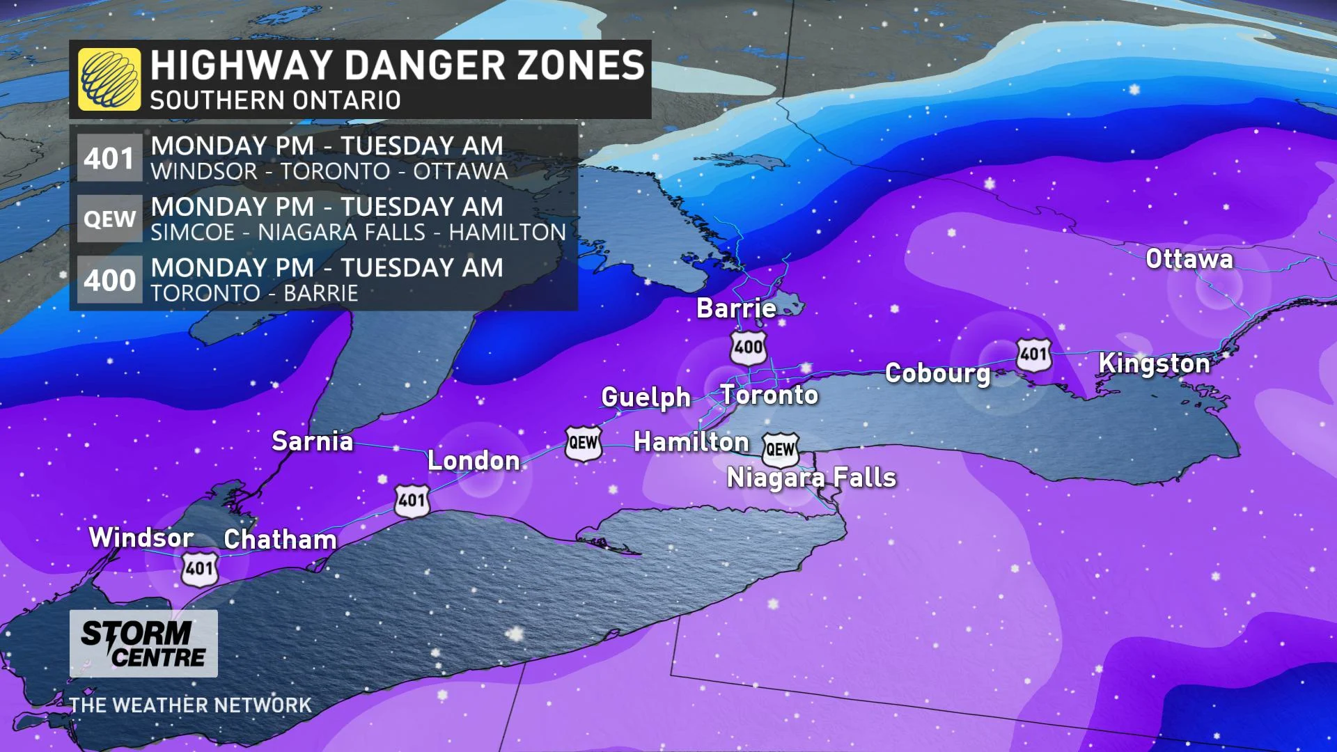
Dangerous road conditions threatened much of Tuesday morning, particularly along Highway 401 from Windsor to Ottawa, the QEW extending from Simcoe to Hamilton, Highway 400 from Toronto Barrie, as well as Highway 410.
"Consider postponing non-essential travel until conditions improve," said Environment Canada in the winter storm warning that spanned parts of Ontario early Tuesday. "Rapidly accumulating snow could make travel difficult over some locations. Visibility may be suddenly reduced at times in heavy snow."
The heaviest snow will ease by early Tuesday afternoon, with lingering flurries possible as the day wears on. Snow squall watches and warnings were issued for the Sarnia area however, with bands of lake-effect snow moving in off of Lake Huron.
The snow will gradually taper from west to east into the afternoon hours.
Widespread snow totals of 15-25 cm are expected across much of southern Ontario through Tuesday, including the Greater Toronto Area. Even higher amounts are forecast in the Niagara region, where 25-35 cm is possible, and also southwestern and eastern sections of the province, where up to 25 cm may fall.
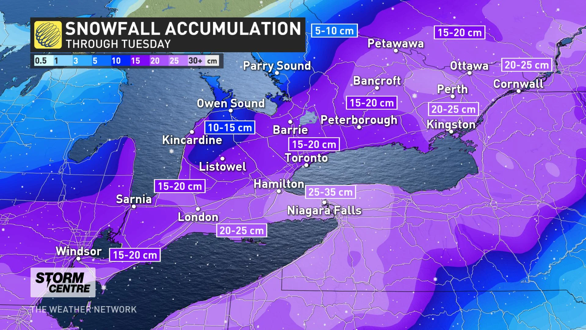
"This could be perhaps the largest snowstorm of the winter season for the GTA with pockets over 20 cm, especially as you move towards Hamilton and the escarpment, where we are looking at 30 cm of snowfall through Tuesday morning," says Weather Network meteorologist Tyler Hamilton.
Police officials have been warning drivers to take it slow and adjust to the changing conditions. According to OPP Sgt. Kerry Schmidt, officers responded to 100 crashes within just 24 hours across GTA by early Tuesday morning.
The wind and frigid temperatures that accompany the snow prompted the city of Toronto to issue an extreme cold weather alert on Tuesday. With the wind chill, temperatures were feeling closer to the -20s Tuesday morning.
LOOK AHEAD: ANOTHER WINTER STORM ON THURSDAY
As this storm winds down and the snow clean-up continues, forecasters are quickly shifting focus to a late-week system that will track across the eastern United States on Thursday, and could threaten more significant snow in southern Ontario by week's end. As of now, the system could bring a widespread 5-10 cm of snow to the region, starting Thursday afternoon and continuing into Friday morning.
"If this storm verifies, our seven-day snowfall totals for parts of southern Ontario could be rather impressive with the parade of storms," says Weather Network meteorologist Dr. Doug Gillham.
The cold pattern will relax for the final week of February, with temperatures trending to near or slightly above seasonal for next week.
Be sure to check back for the latest on the winter weather in Ontario.
Thumbnail credit: Darrylw71