Travel, power impacts likely in Ontario with messy spring storm
A potent spring storm will likely cause travel headaches for Ontario motorists on Wednesday and Thursday, thanks to a blast of blustery winds, drenching rains and a swath of heavy snow
April's first storm began to make its presence felt in Ontario Tuesday, and will only worsen with stronger impacts on Wednesday and Thursday.
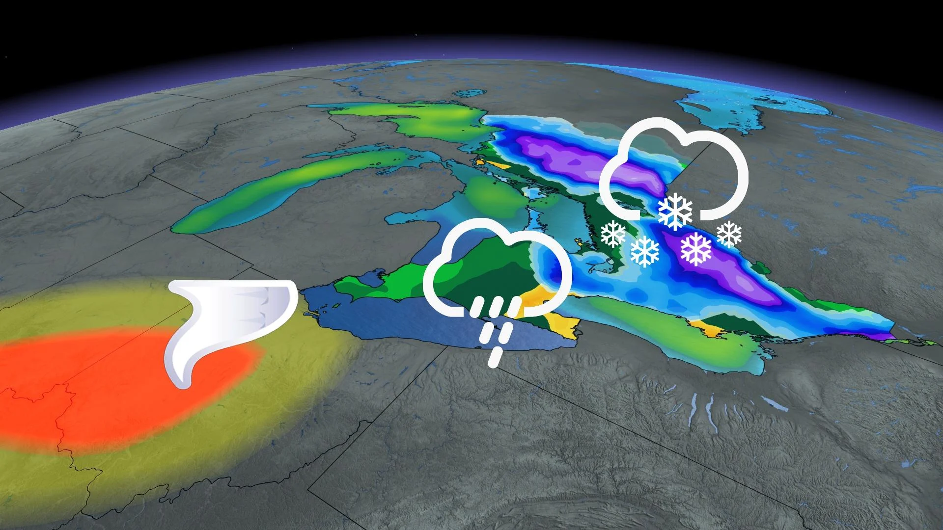
The hazard-loaded storm will be bringing a barrage of effects including heavy rainfall, intense wind gusts and a round of hefty snowfall for some.
DON'T MISS: Canada faces a fickle April as winter wanes and summer teases
Special weather statements and snowfall warnings line much of Ontario, advising of the impacts, including travel and power disruptions, and a potential for localized flooding from the rainfall. Consider modifying travel plans to avoid the worst of the impacts.
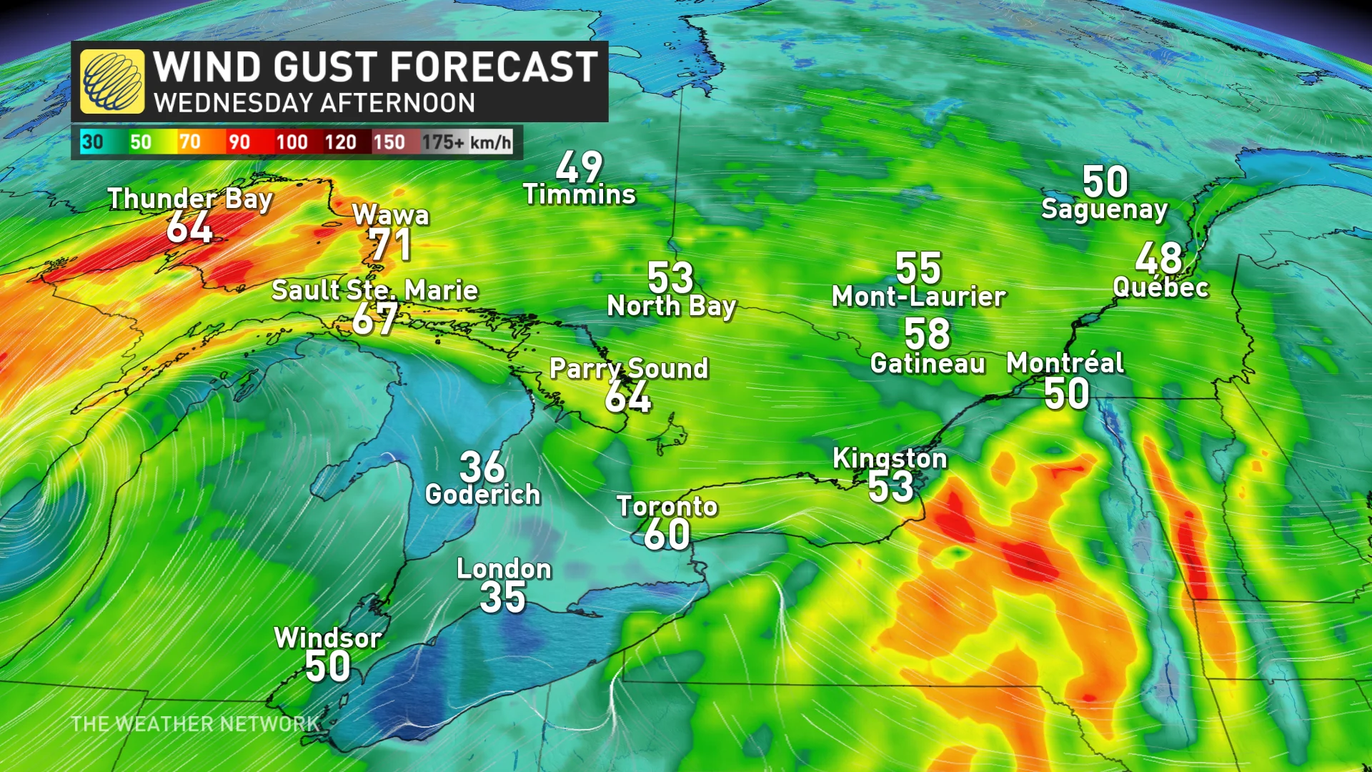
Intensifying winds through Wednesday could result in localized tree damage and power outages. Ensure your devices are charged.
Wednesday into Thursday: Heavy rain persists with a gradual transition over to snow
The greatest impacts from this messy setup will likely be felt on Wednesday as our first storm continues, and our second low-pressure system ramps up.
The rain will become quite heavy Wednesday morning, from the Greater Toronto Area (GTA) and north towards cottage country. Thunderstorms are also possible across southern and eastern Ontario, including the GTA.
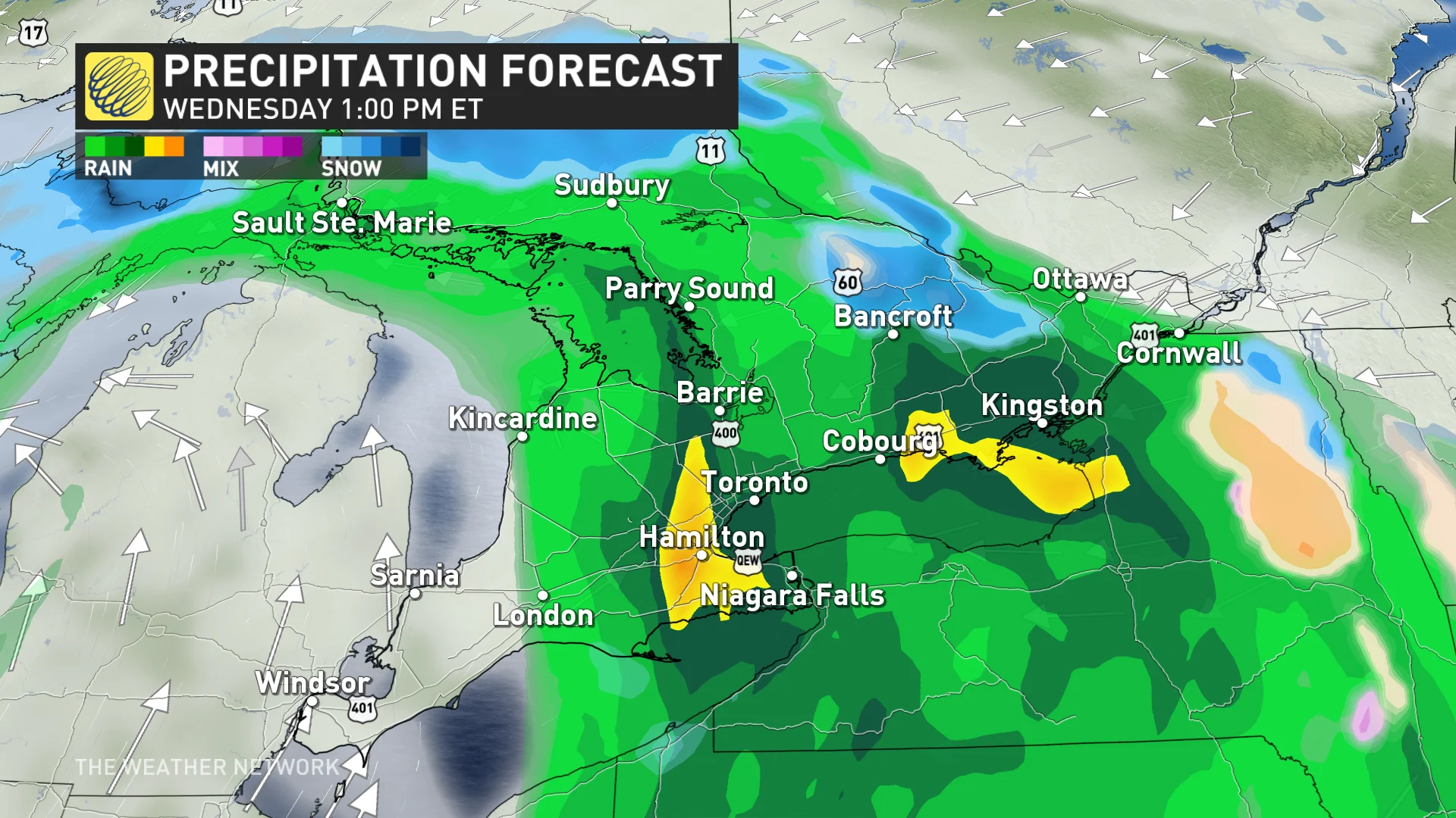
Rain will move into eastern Ontario in the later morning or early-afternoon hours as snow falls in the Algonquin Highlands. Some higher elevations on the escarpment, north of the city, will start to transition to snow in the afternoon.
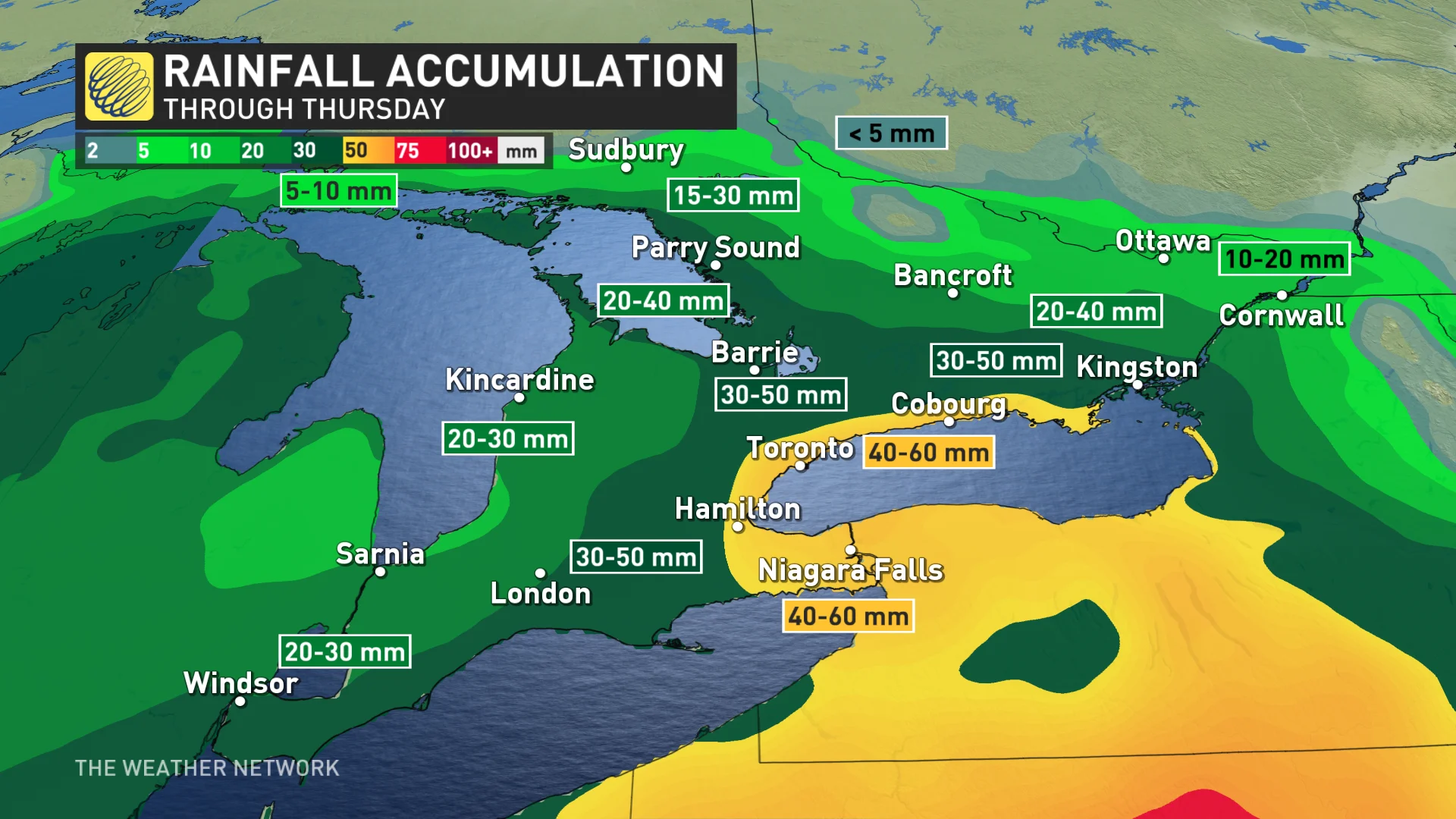
Between 30-60 mm of rain is forecast for the hardest-hit areas, which could result in some localized flooding. There won't be a widespread flood threat this time around, due to the lack of snowpack and lower than normal precipitation this past winter.
Wind gusts will also remain high for the GTA, central, eastern, and northeastern Ontario through Wednesday. They will gradually subside for southwestern areas.
For some areas, this will be a long-duration snowfall that’ll unfold through much of Wednesday and Thursday.
Temperatures will fall as the storm pulls in colder air from the north, and we’ll see the rain transition to wet snow across higher terrain, with a heavy band of accumulating, wet snow across northeastern and eastern Ontario.
Periods of wet snow will fill in across GTA and the south through the overnight hours, with all of the south transitioning to wet snow by Thursday morning. However, it will slowly ease through the day.
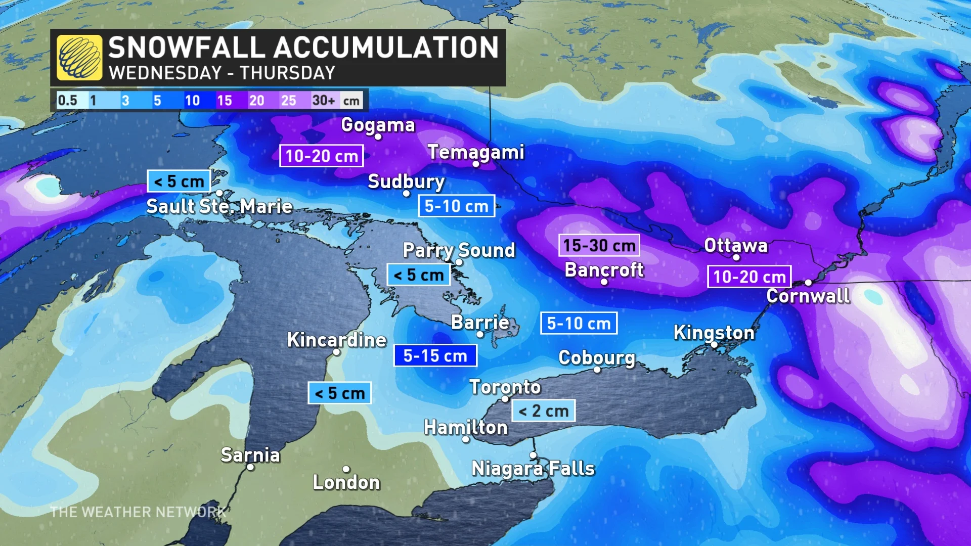
Accumulating snow is possible for higher elevations near Orangeville, Shelburne, and the Waterloo region, with between 5-15 cm likely there.
Cottage country and eastern Ontario appear to be facing the heaviest snow threat with this system, but where exactly the axis of heaviest snow develops will determine which areas see the greatest accumulations. Temperatures will also play a role.
The Algonquin Highlands and parts of central Ontario could see 15-30 cm of snow, with as much as 10-20 cm of snow possible for eastern Ontario, including Ottawa and Cornwall. Periods of snow may move back in Friday for eastern Ontario, as well.
Expect blustery and chilly conditions for a couple days as the system slowly departs the region, then a warming trend into the weekend with temperatures climbing well above seasonal.
Forecasters will continue to monitor conditions ahead of the total solar eclipse that’ll traverse the region on Monday, April 8.
Check back frequently for the latest on this evolving forecast over Ontario.