Tornado watch as severe storm risk reignites on the Prairies
The multi-day setup for severe weather will stay put on the eastern Prairies for Sunday and Monday, shifting farther east each day. Monday's risk will see a chance of rotating storms in southern Manitoba
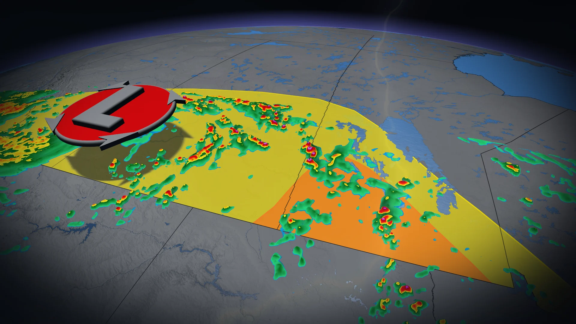
12:23 p.m. CST/1:23 p.m. CDT - A tornado watch is in effect across portions of southern Saskatchewan and southern Manitoba amid a severe storm risk on Sunday afternoon. A tornado watch means that conditions are favourable for the development of tornadoes.
Any severe storms that develop may also be capable of producing strong winds, large hail, and heavy rainfall, Environment and Climate Change Canada (ECCC) added in its watch.

Pay close attention to the latest alerts in case the tornado watch is upgraded to a tornado warning in your area. Have a plan in place to seek safe shelter in case severe weather threatens your home, your office, or while you’re driving.
The original article with the full forecast for the Prairies continues below.
A stormy Saturday across portions of the Prairies served as a prelude to additional rounds of severe weather expected on Sunday and Monday.
The threat will shift a bit east each day, with the severe storm threat including both Manitoba and northwestern Ontario. Monday will see a tornadic chance return in southern Manitoba, including Winnipeg.
Stay aware of severe weather watches and warnings in your area, especially if you have outdoor plans over the next couple of days.
DON'T MISS: Ready or not, Canada expecting high-impact weather to finish June
Additional severe weather expected Sunday
Through Saturday overnight, storms tracked across southern Saskatchewan.

Significant instability will rebuild heading into daytime heating on Sunday, setting the stage for a renewed threat for severe thunderstorms in the afternoon and evening. Sunday’s strongest storms could produce strong wind gusts, large hail, and heavy rainfall.
Around 2 p.m. to 3 p.m. CT, thunderstorm cells will begin to form east of the low-pressure system in southern Manitoba and southeastern Saskatchewan.

The more severe storms are expected to pop up around 5 p.m. CT along the southern Saskatchewan-Manitoba border, as well as southern Saskatchewan.
The jet stream will bring a greater, upper-level support to Sunday and Monday’s thunderstorms. Gulf moisture continues to support elevated rainfall totals.
The tornado threat is not notable, unlike Saturday and Monday.
Monday storm threat shifts into northwestern Ontario, rotating storms possible in Manitoba
Monday’s risk for severe weather will shift east into northwestern Ontario, where models suggest we could see high to extreme levels of thunderstorm energy. If it plays out as models suggest, this setup could produce damaging winds, large hail, and even rotating storms.

Meanwhile, lingering severe thunderstorms remain possible over portions of Manitoba. The corridor of greatest severe potential is near Winnipeg, where there is potential for rotation.
The jet stream will strengthen over the area, providing stronger, upper-level support for the development of thunderstorms through Monday afternoon and evening.

In the Brandon to Winnipeg corridor, people could be caught off guard by an earlier-than-normal start to the severe storms (late morning or lunch time).
Storms will begin to enter the region, alongside a low-pressure system around 3 p.m. CT, bringing heavy downpours, strong winds gusts and large hail. There is an abundance of instability ahead of this front.
The greatest uncertainty lies in the evolution of the convection.

There is a greater risk of tornadoes on Monday than Sunday. Depending on the timing and speed of the system, portions of southeastern Manitoba and northwestern Ontario could see the risk of severe thunderstorms with tornadic potential.
Stay with The Weather Network for all the latest on conditions across the region.