Tornado warning issued as severe storms hit the Prairies
The stormy pattern on the Prairies stays put on Sunday, with a severe weather risk encompassing portions of Alberta and Manitoba. There will be a potential for large hail, heavy rain and strong wind gusts in locales such as Calgary, Medicine Hat and Brandon.
6:35 p.m. CDT - Severe thunderstorms prompted a tornado warning in southern Manitoba on Sunday evening.
Environment and Climate Change Canada issued a tornado warning for the following areas in southern Manitoba:
Jackhead Res.
Mun. of Bifrost-Riverton incl. Arborg Hnausa and Hecla
Peguis Res. and Fisher River Res.
R.M. of Fisher incl. Poplarfield
R.M. of Grahamdale incl. Gypsumville Moosehorn and Camper

"This is a dangerous and potentially life-threatening situation. Take cover immediately, if threatening weather approaches," ECCC said in its warning.
The agency added: "Go indoors to a room on the lowest floor, away from outside walls and windows, such as a basement, bathroom, stairwell or interior closet. Leave mobile homes, vehicles, tents, trailers and other temporary or free-standing shelter, and move to a strong building if you can. As a last resort, lie in a low spot and protect your head from flying debris.”
CURRENT TORNADO WARNINGS (MANITOBA):
Jackhead Res.
Mun. of Bifrost-Riverton incl. Arborg Hnausa and Hecla
Peguis Res. and Fisher River Res.
R.M. of Fisher incl. Poplarfield
R.M. of Grahamdale incl. Gypsumville Moosehorn and Camper
1:23 p.m. CST/2:23 p.m. CDT - A tornado watch is in effect across portions of southern Saskatchewan and southern Manitoba amid a severe storm risk on Sunday afternoon. A tornado watch means that conditions are favourable for the development of tornadoes.

Pay close attention to the latest alerts in case the tornado watch is upgraded to a tornado warning in your area. Have a plan in place to seek safe shelter in case severe weather threatens your home, your office, or while you’re driving.
The original article with the full forecast for the Prairies continues below.
The Prairies are bracing for a reignited setup for severe weather potential on Sunday after tornado-warned storms hit parts of Alberta and Saskatchewan, a pattern that's been ongoing in recent days.
Stay aware of severe weather watches and warnings in your area, especially if you have outdoor plans.
DON'T MISS: Ready or not, Canada expecting high-impact weather to finish June
More severe weather expected Sunday and into Monday morning
Moisture continues to meander across the Prairies, providing plenty of fuel for another active day of thunderstorms on Sunday.
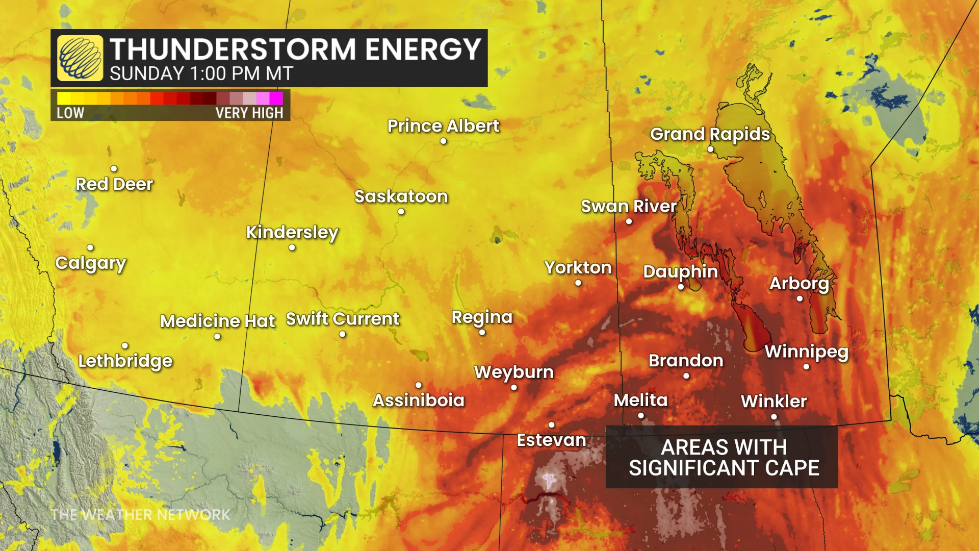
Warm, humid air, combined with upper-level support, will create favourable conditions for severe weather across portions of the Prairies. The greatest threat will be focused on Alberta and Manitoba.
The greatest severe thunderstorm risk will develop across southern Alberta and southern Manitoba through the afternoon and evening.
Thunderstorms are expected to begin developing mid-to-late afternoon (around 4 p.m. MT) across portions of Alberta, alongside a cold front associated with a low-pressure system draped across the Prairies.

Southern Manitoba will have the greatest instability and wind shear, leading to a risk for one or two tornadoes across the region through the evening hours.
As the low-pressure system continues to move east, eventually moving into northwestern Ontario early Monday, the cold front will support the development of nocturnal thunderstorms across southern Saskatchewan, and southern and central Manitoba overnight.
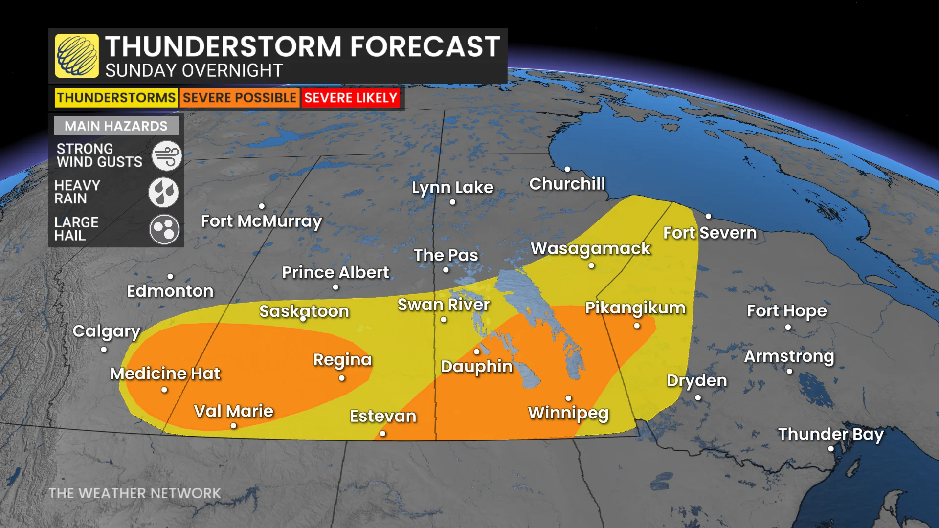
Strong wind gusts are expected ahead of the front, with overnight gusts reaching around 60 km/h for areas in southern Alberta and central Manitoba.
Most areas across the Prairies are expected to receive 10 to 15 mm of rainfall through the next five days. However, northeastern Alberta and northwestern Ontario could see more than 50 mm from multiple rounds of showers and thunderstorms.

Rainfall totals may increase depending on the exact timing and track of the system.
Stay with The Weather Network for all the latest on conditions across the region.