
Tornado warnings issued in southern Manitoba as severe storms fire up
A severe thunderstorm capable of producing a tornado has been detected in southern Manitoba. Residents in the affected region should be in their shelters.
Tornado warnings have been issued in southern Manitoba as meteorologists with Environment and Climate Change Canada (ECCC) are tracking a thunderstorm that is potentially producing a tornado.
In addition to potentially producing a tornado and intense winds, large hail and locally intense rainfall are possible. See below for the details.
Current tornado warnings
R.M. of West Interlake incl. Eriksdale and Ashern
R.M. of Grahamdale incl. Gypsumville Moosehorn and Camper
R.M. of Dufferin incl. Carman Roseisle and Homewood
R.M. of Roland incl. Jordan and Myrtle
5:19 PM CST: Environment Canada meteorologists are tracking a severe thunderstorm that is possibly producing a tornado. Damaging winds, large hail and locally intense rainfall are also possible.

This is a dangerous and potentially life-threatening situation.
Take cover immediately, if threatening weather approaches. If you hear a roaring sound or see a funnel cloud, swirling debris near the ground, flying debris, or any threatening weather approaching, take shelter immediately.
Go indoors to a room on the lowest floor, away from outside walls and windows, such as a basement, bathroom, stairwell or interior closet. Leave mobile homes, vehicles, tents, trailers and other temporary or free-standing shelter, and move to a strong building if you can. As a last resort, lie in a low spot and protect your head from flying debris.
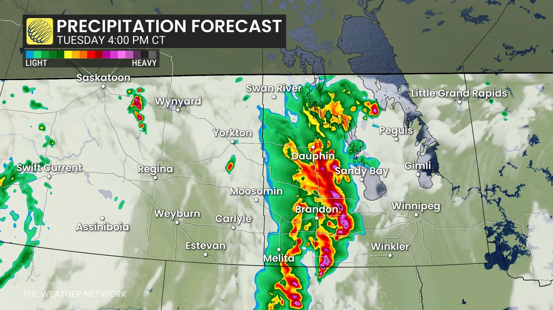
Severe thunderstorms, large hail, and tornado risk for southern Manitoba Tuesday
Severe thunderstorms are expected Tuesday as a shortwave trough moves across southern Manitoba and North Dakota, creating conditions for supercell development.
Wind shear and steep lapse rates will support these storms, with large hail—potentially toonie-sized or larger—as the primary threat. Forecasters suggest one or two tornadoes are also possible, along with strong outflow wind gusts.
RELATED: Stuck in your car during a tornado? Here’s what you should do
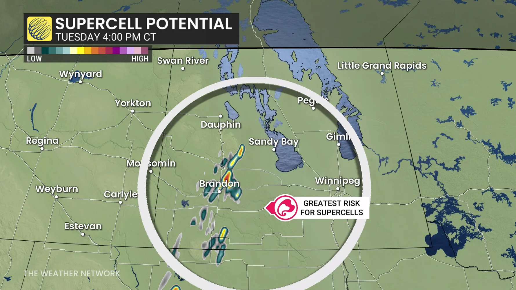
Thunderstorms are forecast to initiate in the U.S. before moving into southwestern Manitoba during the afternoon. Isolated storms will evolve into widespread clusters by early evening, tracking northeast from southwestern Manitoba toward the Interlake and eastern regions.
Brandon faces the greatest storm risk from 3–6 p.m. local time, with thunderstorms expected to reach Winnipeg after dinner and into the evening hours.
SEE ALSO: Tornado WATCH OR WARNING? What you need to know about staying safe
Conditions will stabilize after the system passes, marking the end of the current extreme heat. Stay weather-aware and monitor alerts for updates.