Tornado warning issued as severe storms hit the Prairies
Beware a risk for severe thunderstorms on Saturday on parts of the Prairies, with a chance of large hail and damaging winds. A tornado can't be ruled out for some as supercells will be possible
6:04 p.m. CST - Severe thunderstorms prompted a tornado warning in southern Saskatchewan on Saturday evening.
Environment and Climate Change Canada issued a tornado warning for the following areas in southern Saskatchewan:
R.M. of Frenchman Butte including St. Walburg
R.M. of Mervin including Turtleford Mervin and Spruce Lake

"This is a dangerous and potentially life-threatening situation. Take cover immediately, if threatening weather approaches," ECCC said in its warning.
The agency added: "Go indoors to a room on the lowest floor, away from outside walls and windows, such as a basement, bathroom, stairwell or interior closet. Leave mobile homes, vehicles, tents, trailers and other temporary or free-standing shelter, and move to a strong building if you can. As a last resort, lie in a low spot and protect your head from flying debris.”
CURRENT TORNADO WARNINGS (SASKATCHEWAN):
R.M. of Frenchman Butte including St. Walburg
R.M. of Mervin including Turtleford Mervin and Spruce Lake
1:27 p.m. CST - A tornado watch is in effect across portions of southern Saskatchewan amid a severe storm risk on Saturday afternoon. A tornado watch means that conditions are favourable for the development of tornadoes.
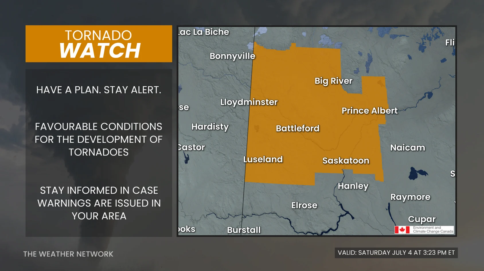
Pay close attention to the latest alerts in case the tornado watch is upgraded to a tornado warning in your area. Have a plan in place to seek safe shelter in case severe weather threatens your home, your office, or while you’re driving.
The original article with the full forecast for the Prairies continues below.
The Prairies are bracing for yet another round of severe weather on Saturday, a setup that's been ongoing in recent days.
Stay aware of severe weather watches and warnings in your area, especially if you have outdoor plans.
DON'T MISS: Ready or not, Canada expecting high-impact weather to finish June

Additional severe weather expected Saturday
A strengthening, low-pressure system and upper-level energy will trigger another active day of thunderstorms across the Prairies on Saturday.
Warm, humid air and favourable wind shear will create an environment capable of producing supercell thunderstorms, especially across Alberta and Saskatchewan.
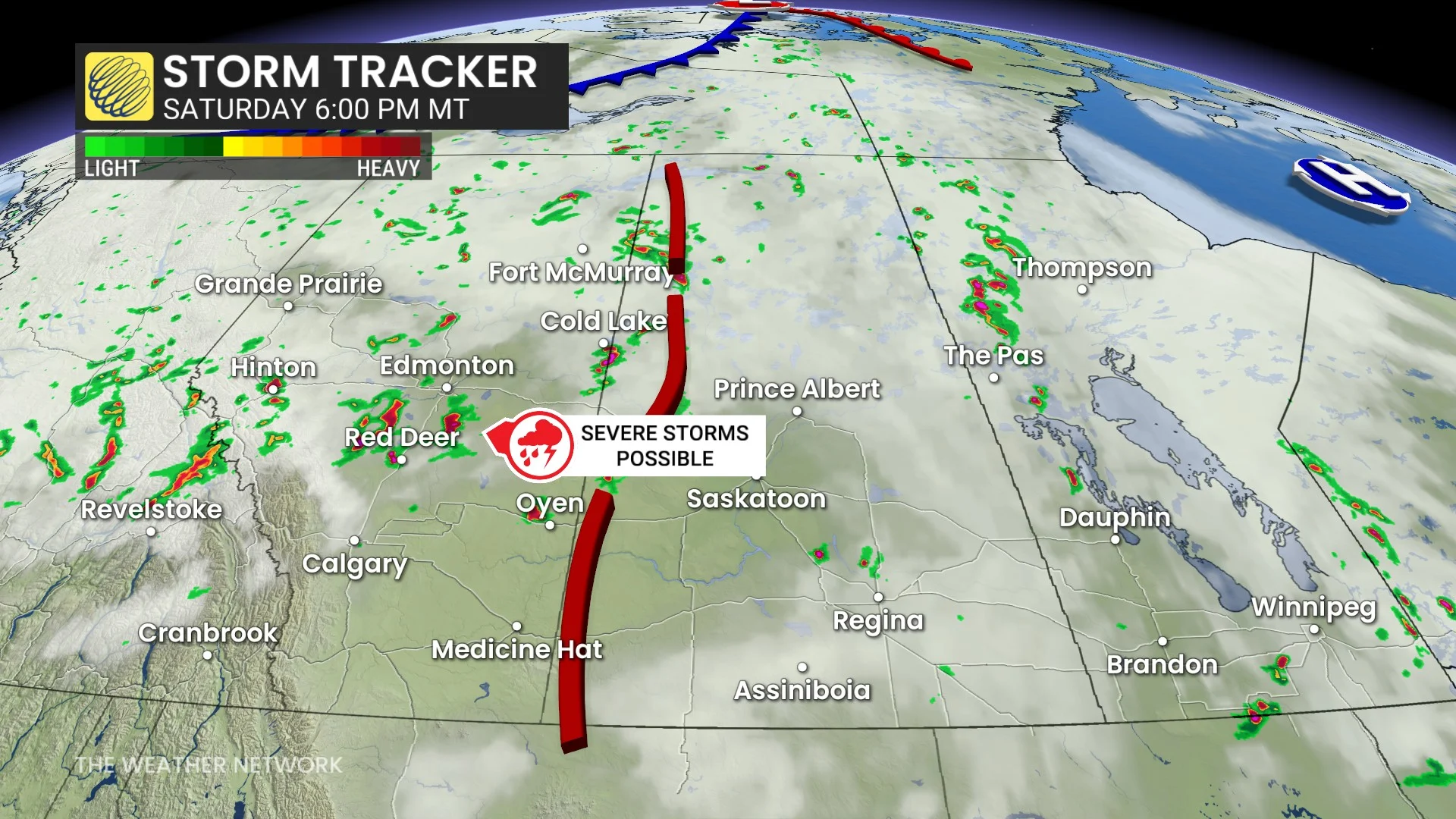
The greatest severe weather risk is across central and southern Alberta, spreading into central Saskatchewan through the afternoon and evening.
Storms may begin as discrete supercells before growing into larger clusters as they move east.

Very large hail, damaging wind gusts, and one or two tornadoes are all possible.
Storms tracking from Alberta into Saskatchewan will be fast-moving, increasing the risk of widespread, damaging winds and large hail.

Farther east into eastern Saskatchewan and western Manitoba, scattered, severe storms are possible later in the day. The primary threats will be large hail and damaging wind gusts, though storms may be more isolated than those farther west.
Stay with The Weather Network for all the latest on conditions across the region.