Snow lingers through the overnight for parts of the Greater Toronto Area

Overnight travellers will need to be mindful on the roads, as there's still a few flakes of snow to come before
Lake-effect snow squalls stretched well inland from Lake Huron and Georgian Bay Wednesday, with bursts of snow making for tricky conditions on the roads, even for parts of the GTA. The worst was over Wednesday evening, but some light snow looks to linger until early Thursday for parts of the GTA, Hamilton and Niagara regions. More on what remains of the snow, plus why we're looking at a "last minute" shot at a white Christmas, below.
WEATHER HIGHLIGHTS:
Light snow may linger into the early morning hours Thursday morning, though ending quickly
Conditions trend milder for the weekend, period of rain and snow showers ahead of changeable pattern for Christmas week
Visit our Complete Guide to Winter 2021 for an in depth look at the Winter Forecast, Canada's ski season, and tips to plan for everything ahead!
INTO THURSDAY: SNOW TAPERS OFF
Cold winds made for several bursts of lake-effect snow Wednesday, stretching far enough inland from Lake Huron and Georgian Bay that Environment Canada issued a weather advisory covering Halton and Peel regions, as well as the Hamilton Area.
"Under the lake effect bands heavy bursts of snow and blowing snow can significantly reduce visibilities," the weather agency warned evening travellers.
Dreaming of a snowy festive season? Click here to find out if your holiday wishes will come true!
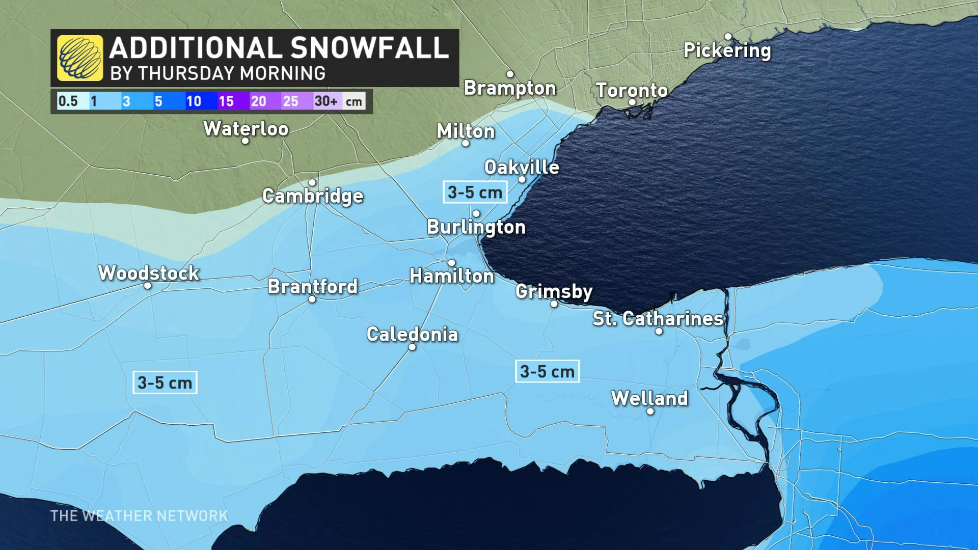
Some 3-5 cm of additional snowfall is possible by the early morning hours Thursday, though tapering off quickly.
Temperatures will remain cold through Thursday, with light snow flurries most persistent across the Niagara region, especially between Vineland and Hamilton.
ICY WATERFRONTS ALONG LAKE ONTARIO AS STIFF WINDS CONTINUE OVERNIGHT
LATE WEEK AND BEYOND: CLIMBING OUT OF THE FREEZE, LAST MINUTE CALL FOR A WHITE CHRISTMAS
More sunshine and fair conditions will round out the work week on Friday, with daytime highs climbing above freezing and a milder weekend in store. A weak system will also track across the region this weekend, bringing scattered rain and snow showers late Saturday and through early Sunday.
For the week and days leading up to Christmas, a changeable pattern is forecast, but with temperatures likely tipping to the mild side of seasonal.
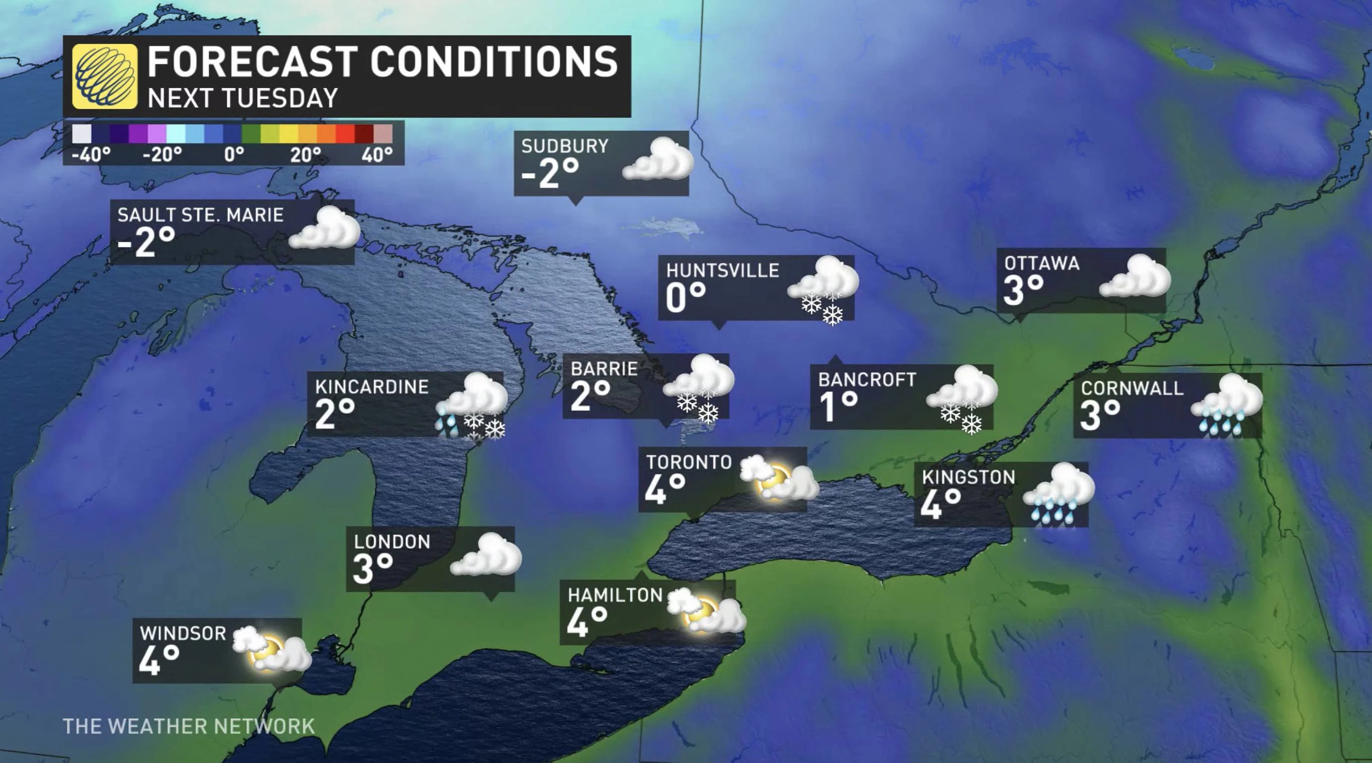
"Whether or not we see a white Christmas will likely come down the the wire and depend on the track of another system around Christmas Eve which could bring rain or snow to our region," says Gillham. "Behind this system we expect a few days of cold weather, likely including Christmas and Boxing Day."
Check back as we continue to monitor the forecast and latest weather conditions in your area.