Path of Hurricane Lee and possible Canadian impacts becoming clearer

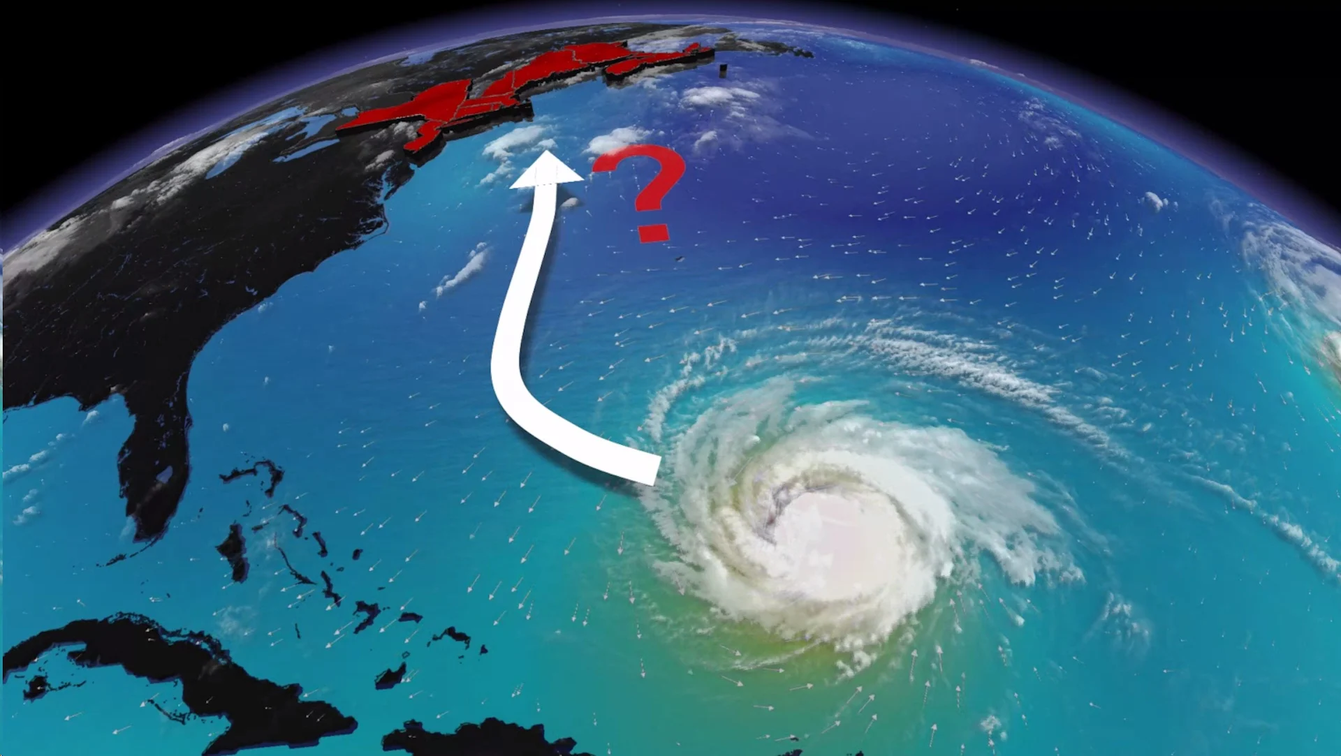
Several scenarios remain possible with Hurricane Lee’s track this week, but concern is mounting that Atlantic Canada may feel some effects this weekend
Hurricane Lee regained its major storm status Monday as its future path became a little more clear, raising concerns over potential impacts to Atlantic Canada by the weekend.
However, several scenarios are still on the table right now, and the storm’s eventual track depends on the precise timing and location of key factors.
Visit The Weather Network's hurricane hub to keep up with the latest on tropical developments in Canada and around the world
Small changes could have a large impact on Lee’s track over the next five to seven days.
Lee regains major hurricane status
Crews flying through the storm saw it beginning to regroup on Sunday, reforming a distinct eye in a bid to regain some of its strength heading into the beginning of the work week.
DON'T MISS: A world first, every tropical ocean saw a Category 5 storm in 2023
It is now a major hurricane once more.
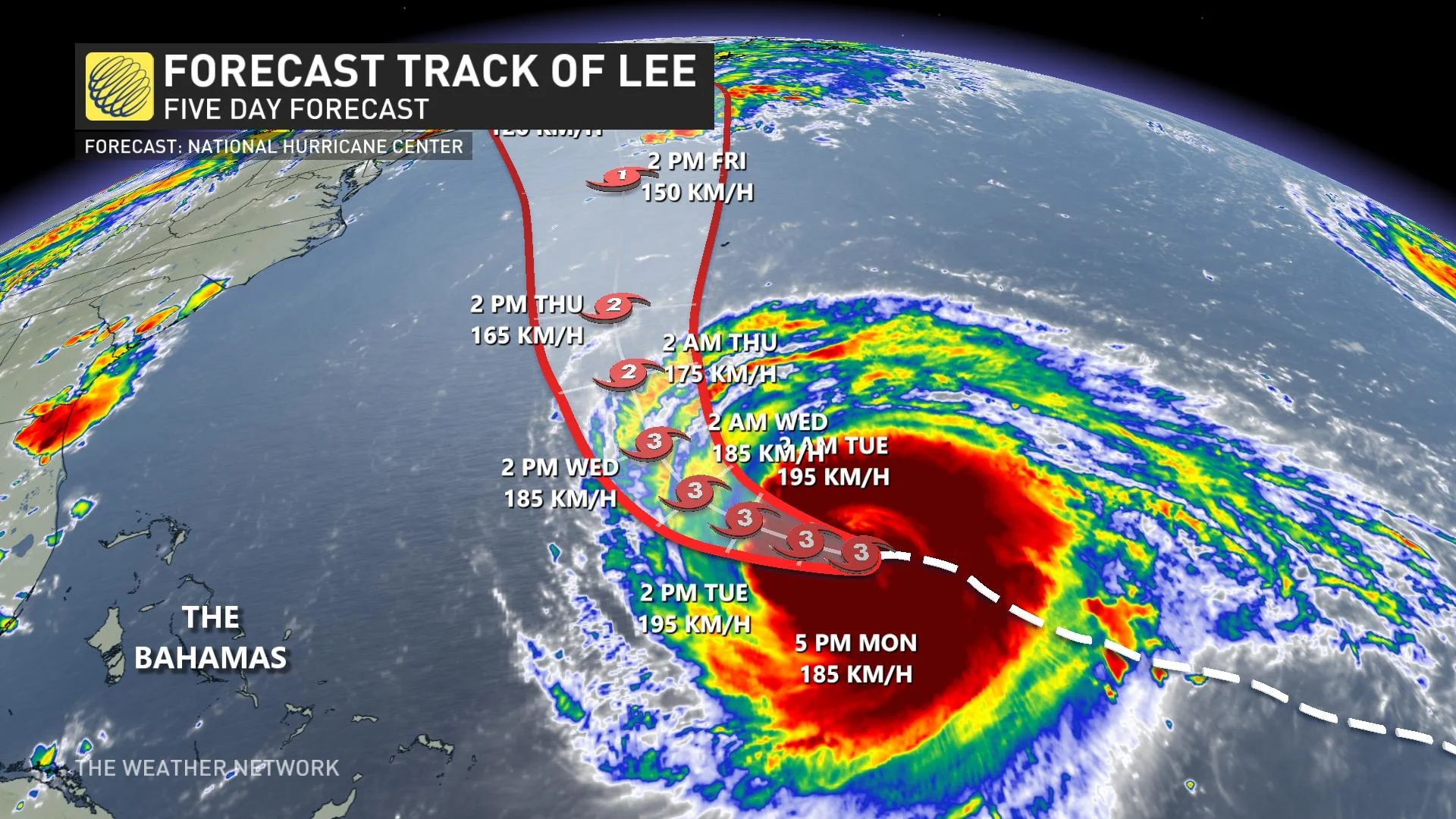
The latest forecast from the U.S. National Hurricane Center (NHC) on Monday evening said Lee has maximum, sustained winds are near 185 km/h with higher gusts. Lee is a Category 3 storm. Little change in strength is forecast during the next couple of days.
However, it will weaken once it hits slightly cooler waters in its northward path this week.
"Lee remains a slow-moving, major hurricane. Hazardous surf and rip current conditions expected at beaches across the western Atlantic all week," the NHC said.
Lee will weaken a bit as it climbs north and grows in size
It’s important to note that Lee will not remain at its peak strength as it starts turning north by the middle of this week.
Tropical systems tend to grow in size as they curve toward the north, spreading their energy over a wider area rather than focusing all their power on a relatively tiny part of the storm.
The fact that Hurricane Lee’s footprint will slowly grow in size is important for any communities in the eventual path of the storm. A threat for heavy rains, high winds, and coastal flooding could extend hundreds of kilometres from the centre of the hurricane.
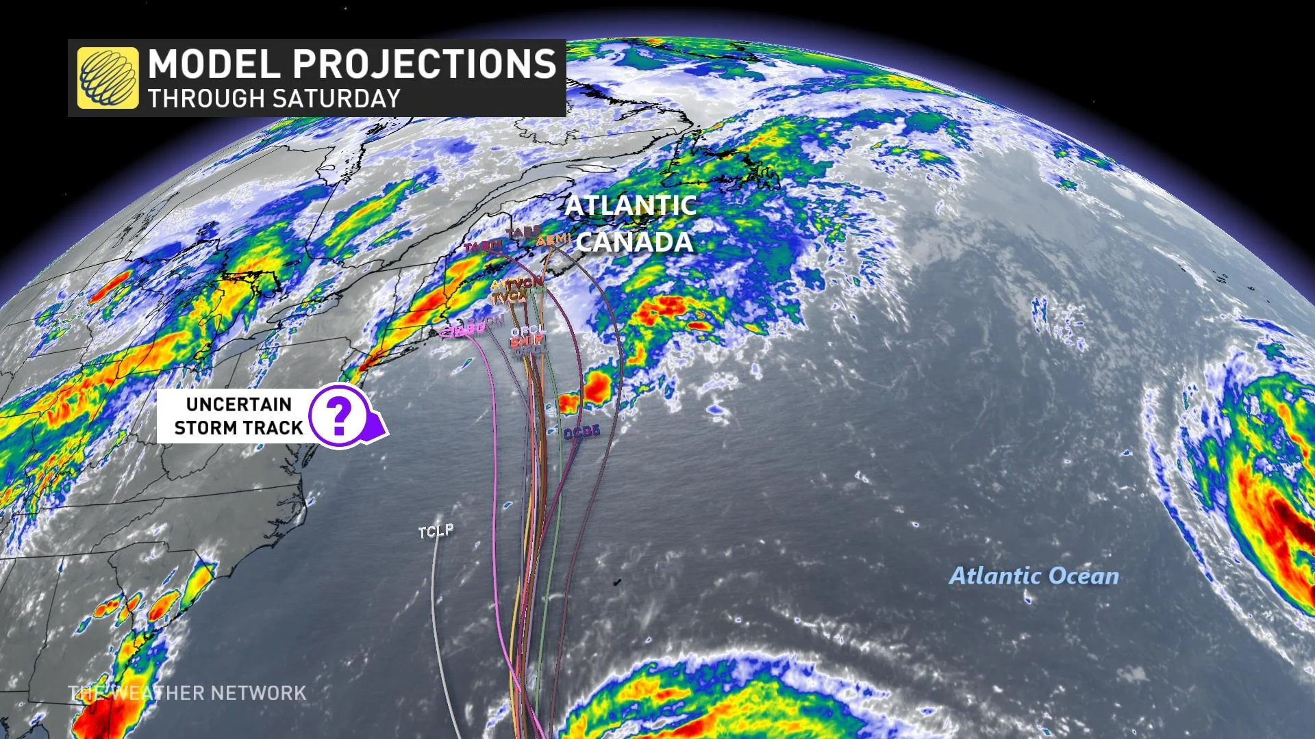
Hurricane Lee’s eventual track will depend on several factors ahead of the storm.
Initial statement issued by the Canadian Hurricane Centre
The Canadian Hurricane Centre (CHC) has issued a preliminary tropical cyclone information statement. The initial bulletin is anchored to the offshore marine district south of Nova Scotia where the circulation of Lee would encroach upon first.
“We are starting to get a better idea of how the weather will evolve this week over Atlantic Canada and the role Hurricane Lee may play," the CHC said in the statement.
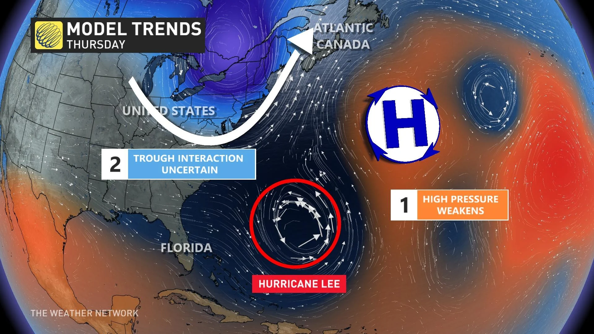
A ridge of high pressure over the Atlantic is responsible for steering toward the west-northwest right now.
Once the hurricane makes a northward turn by late Wednesday, it will further enhance the tropical air mass over Atlantic Canada. It will also have the effect of slowing the progress of a front, which could increase the risk of heavy rainfall over the Maritime provinces during the latter part of the week.
"Given these factors, the storm would approach the region as a weak hurricane or strong tropical storm. The range of track possibilities is very broad this far ahead in time, ranging from somewhere in Maine to the southeast of Nova Scotia," said CHC.
At the same time, Hurricane Lee will start to feel the influence of an upper-level trough dipping over the Great Lakes toward the end of the week. Southerly winds blowing around this trough will help push Lee toward the north with increasing speed on Thursday and through the weekend.
The precise timing of this turn and the strength of that trough will determine exactly where Lee tracks.
Scenario 1: Lee turns into New England
One scenario that’s possible is that the trough over the Great Lakes is a little bit weaker than expected. This would allow a ridge of high pressure to set up near the Maritimes, potentially forcing Lee to turn west and head into New England.
MUST SEE: How a mammoth hurricane rapidly intensifies in mere hours
This scenario would bring hazardous conditions to the bustling Interstate 95 corridor throughout New England -— a heavily travelled corridor by Canadians visiting the United States —- while potentially bringing some wind, rain, large costal waves and erosion to southern sections of the Maritimes.
Scenario 2: Lee tracks into Atlantic Canada
Another scenario consistently showing up in weather models is that prevailing winds will keep Hurricane Lee on a northward trajectory, bringing the storm directly into the Maritimes by next weekend.
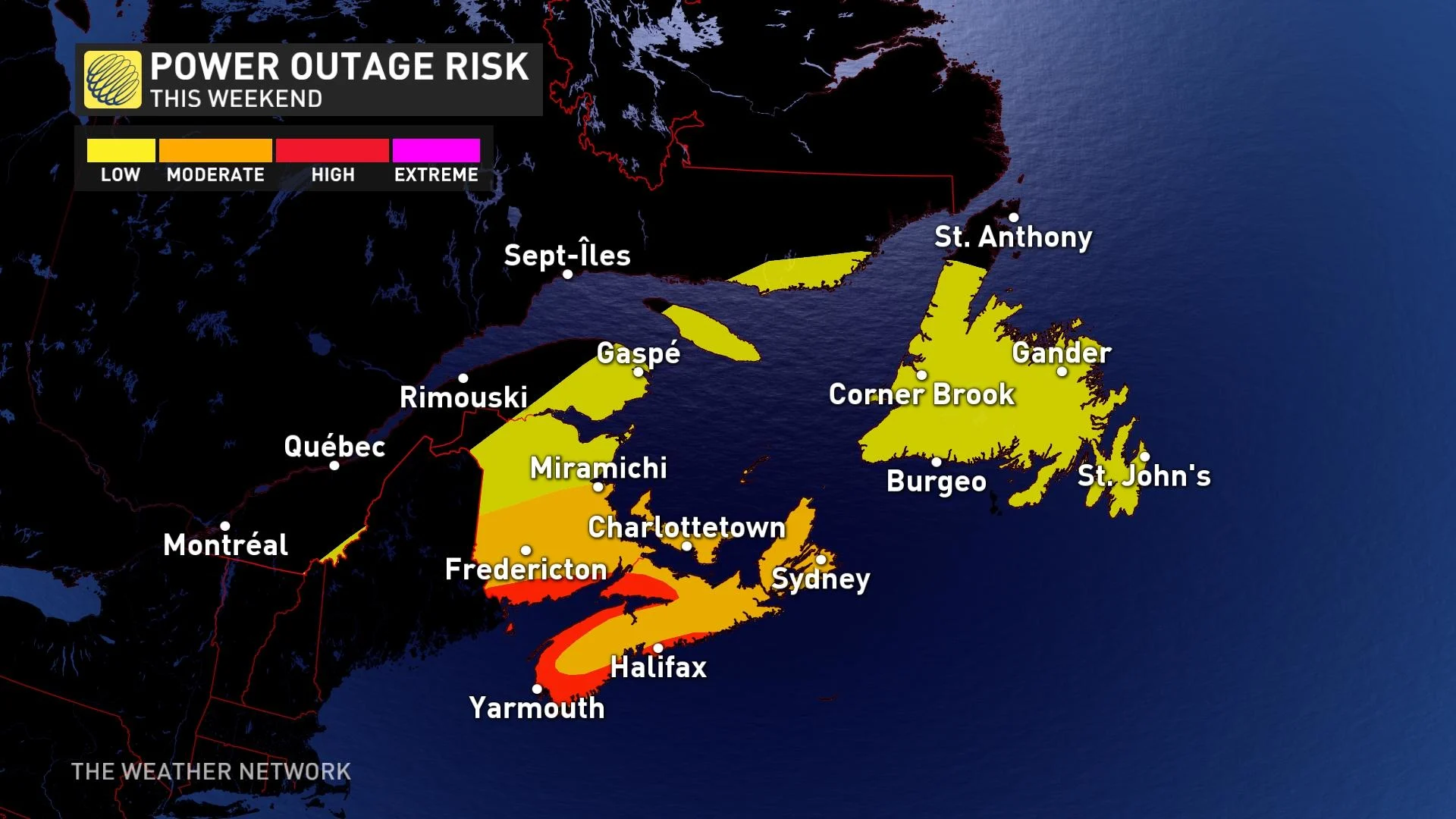
This would be a high-impact event for the region, with heavy rain, high winds, and coastal flooding possible across Nova Scotia, New Brunswick, and Prince Edward Island.
Folks across the region are understandably weary about tropical systems after the impacts of Dorian in 2019 and Fiona in 2022. It’s likely that Hurricane Lee would not be as strong as either of those two systems if it were to hit the region.
However, residents would have to stay on high alert for flooding, power outages, tree damage, and coastal flooding.
Scenario 3: Lee turns toward sea, possibly affecting Newfoundland
It’s still possible that Lee could turn a bit east and follow a track that heads farther out to sea. This is a similar situation to the one we saw with Hurricane Franklin last month -- the storm looked like it might’ve hit Atlantic Canada, but conditions allowed it to turn out to sea. This solution has the lowest probability of verifying compared to the previous two.
If Lee were to turn out to sea, we’d still have to closely monitor potential impacts to Newfoundland, and especially the Avalon Peninsula, by the end of next weekend or early next week.
WATCH: The best time to prepare for a hurricane is long before one threatens. Here's how
Stay prepared
We’re now in the climatological peak of hurricane season across the Atlantic basin. Anyone along or near the East Coast should prepare for hazards like power outages and flooding regardless of this one storm’s progress.
Ensure you’ve got non-perishable food, water, personal hygiene supplies, flashlights, and batteries to last for several days without electricity or water. Prepare an emergency plan in case of flooding or evacuations.
STAY SAFE: What you need in your hurricane preparedness kit
Anxiety is normal when there’s a big storm out there, and even more so when the storm’s future is uncertain. Preparing for a storm now—long before one ever draws near—ensures you’ll be ready to go if anything looms on the horizon in the weeks and months ahead.
Stay with The Weather Network for the duration of this storm as we closely monitor this hurricane and its developments.