Huge temperature rebound coming for Eastern Canada, but there’s a catch

A 30-degree temperature rebound is on the way for much of Eastern Canada in the coming days, but it comes at a catch.
Would you rather have frigid temperatures and sunny skies, or relatively mild temperatures with gloomy conditions?
Many folks across Eastern Canada will be able to answer that question in the coming days. The intense Arctic outbreak that plunged across Ontario, Quebec, and the Atlantic provinces to end the week will scurry out of the area just as fast as it hit.
A ridge building in its place will send temperatures soaring by this week, climbing to above-seasonal levels for many spots.
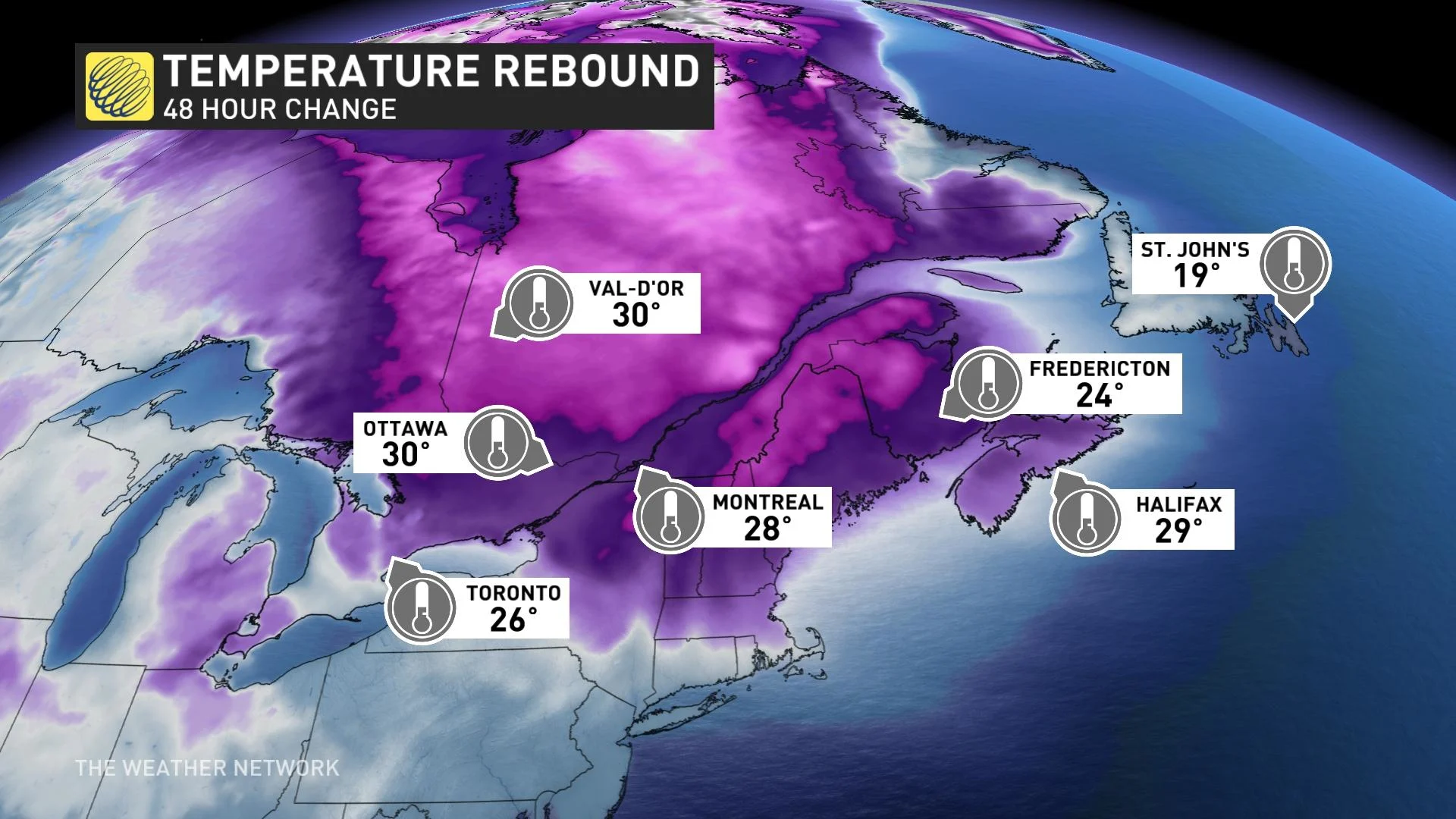
It’s quite the reversal -- some areas will see a temperature swing of more than 30 degrees between Saturday morning and Sunday afternoon.
MUST SEE: Fickle February: Hit and run winter continues to lack commitment
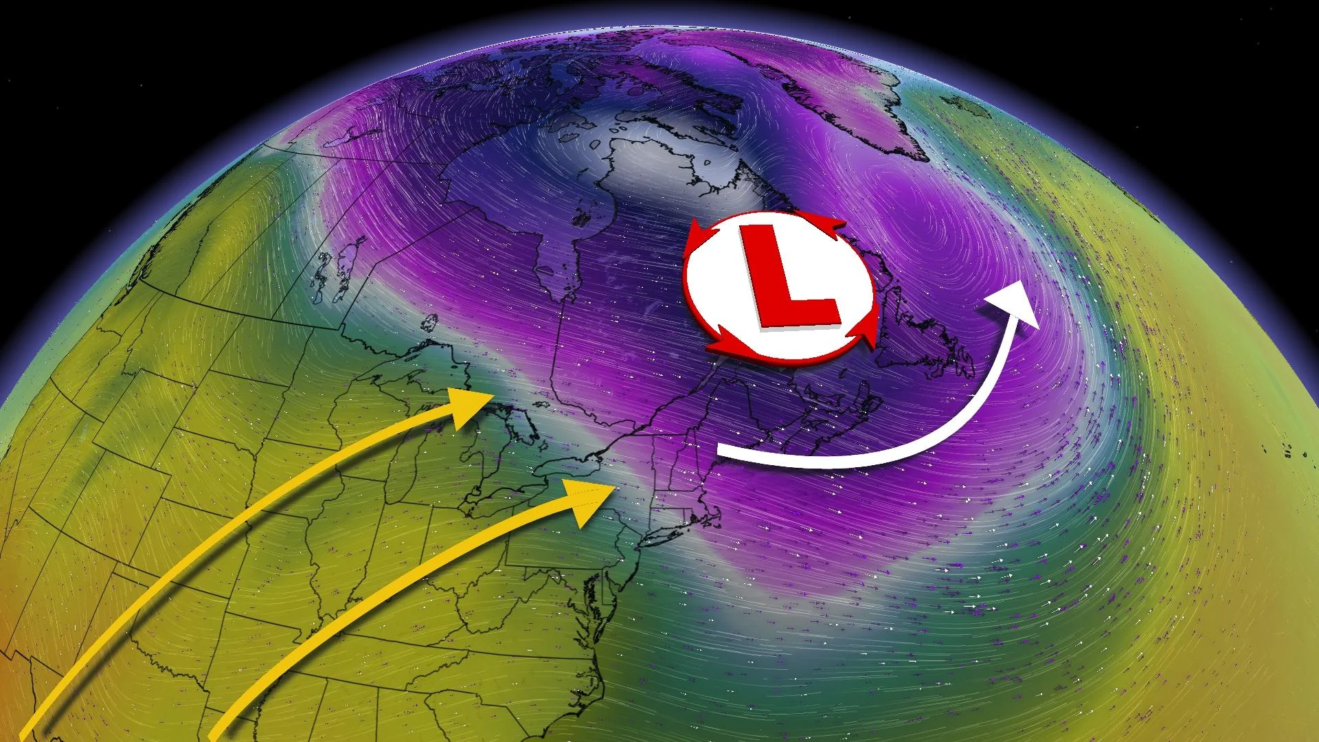
A lobe of the polar vortex descended on Eastern Canada through the latter half of last week, sending temperatures to levels we haven’t seen in decades in some communities.
Despite the clear and sunny skies, Friday’s air temperatures in the -20s and -30s were made even worse by gusty winds behind the Arctic front.
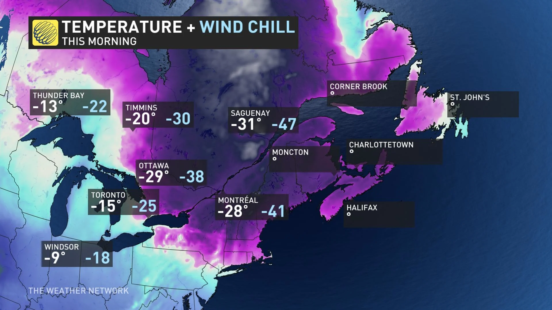
Wind chill values plunged into the -30s through the Greater Toronto Area, the -40s through the National Capital Region and southern Quebec, and even touched -50 in northern sections of Quebec.
The lobe of the polar vortex responsible for dragging this intensely cold air down from the Arctic will move along in a hurry, allowing an upper-level ridge to build over the eastern half of the country instead.

Upper-level ridges foster warmer conditions at the surface, and we’ll see conditions significantly warming up for areas socked in the deep freeze right now
Ottawa’s low of -33.1°C on Saturday morning, enough to make it the city's coldest February day since 1967 (-33.3°C on Feb. 13), will swing to a relatively balmy high of 1°C by Sunday afternoon. Montreal reached -29.5°C, making it the coldest temperature there since Jan. 19, 1994.
We’ll see similar temperature flips between Saturday morning and Sunday afternoon in Toronto (a 25-degree change), Montreal (a swing of 29°C), and Halifax (a 29-degree shift).
PHOTOS: Intense Arctic outbreak creates towering steam devils
Temperatures could warm into the middle- to upper-single digits by the middle of this week for parts of southern Ontario and the Maritimes.
However, such a powerful reversal in atmospheric fortunes almost always comes with a catch.
The same pattern that will allow above-seasonal temperatures to replace the bitterly cold air will also foster an active storm track over the eastern half of the country.
Watch the video below to see how the unsettled pattern could progress next week.
These warmer temperatures will be aided by several systems moving through the region. These disturbances will bring messy, cloudy conditions along with the warmth. While we enjoyed sunny skies amid the dangerously cold temperatures, we’ll have to take gloomy and unsettled conditions with our sudden warmup.
Forecasters will monitor the progress of these systems this week for the potential for unsettled conditions across Ontario, Quebec, and Atlantic Canada.
Despite the relatively warmer temperatures, it is the heart of winter in Canada, and “above-seasonal” in early February is still perfectly cold enough for snow and ice.
Stay with The Weather Network for the latest on conditions across Eastern Canada.


