Huge B.C. warm-up to sway winter-like gloom with late-May comfort
A big temperature swing is on the way to the West Coast this week, so residents can put away the snow shovels and umbrellas, and bring out the spring attire
This week will offer a tour of the seasons in British Columbia as a mid-winter pattern abruptly lurches to a setup resembling the late days of spring.
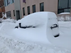
Ample rain and bountiful mountain snows swept B.C. over the weekend as a steady parade of storms washed into the coast. It’s been a fantastic start to the month for ski resorts enduring an epic snow drought this season.
A pattern change is underway that’ll send temperatures soaring by the end of the week.
SEE ALSO: Woman survives being buried by avalanche for almost 20 minutes

We tend to go from feast to famine lately. Some patterns overstay their welcome, while others bring rapid weather changes in short order. The upper atmosphere over Western Canada is churning this week, allowing B.C. to swing from January to May in just a few days.
The disturbances that contributed to our wet weather over the weekend will move downwind in a hurry as we start the week, allowing a spell of calmer conditions to prevail across the province.
A significant ridge of high pressure will build over the U.S. Northwest toward the latter half of the week, the northern half of which will exert its influence over southern B.C.

Air sinks beneath upper-level ridges, warming up as it descends toward the surface. This setup will force temperatures to steadily rise heading toward next weekend.
Highs across the South Coast will reach the lower teens by Thursday, mid-teens by Friday, and soar toward the 20-degree mark by next weekend.
Vancouver could see sunny skies and daytime highs around 18°C through next weekend –– values that are more common of late May than mid-March.
WATCH: Surviving a tree well: The hidden danger on ski hills
Stay tuned to The Weather Network for the latest forecast updates for B.C.