Holiday havoc: Vast, 3,000-km-sized storm puts travel plans in peril
This week's North American storm will stretch a distance of 3,000 km – from the Gulf of Mexico to the shorelines of James Bay, putting holiday excursion plans in jeopardy for millions of people
This forthcoming winter storm set to batter the U.S. and Canada in time for the holidays could be an event we talk about for years to come, or it could just end up being yesterday’s news.
Either way, people will be talking about this storm over dinner through the holidays this year.
SEE ALSO: Windshield wiper blades: Is it a good idea to leave them up before a snowfall?
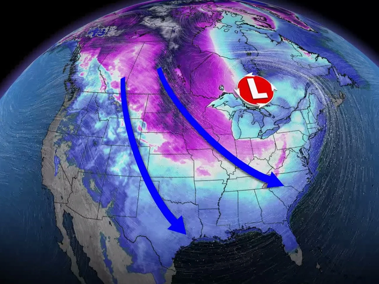
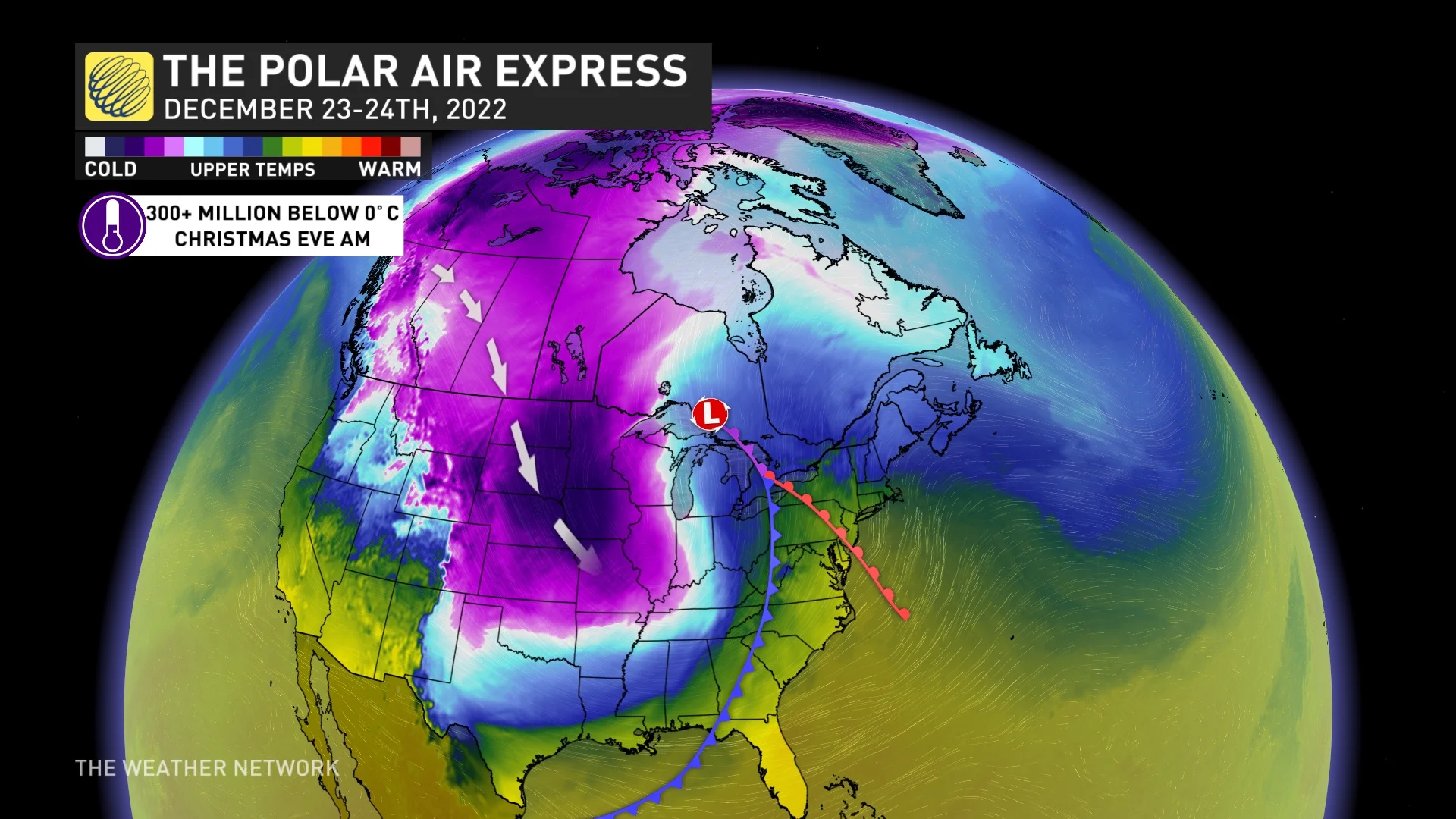
As for what is driving such an expansive storm to develop: A historic surge of Arctic air will spend the next two days diving south from the Arctic to the Gulf of Mexico. In the process, the air mass will trigger an incredibly strong storm heading into the holidays.
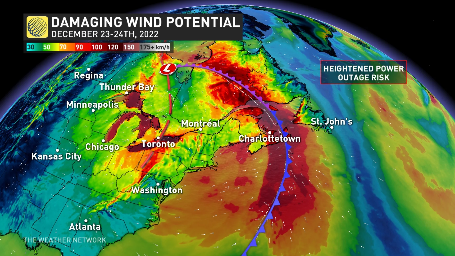
Arctic air will clash with subtropical warmth and moisture over the Mississippi Valley, sparking a weather bomb over the Great Lakes – a situation usually reserved for Atlantic Canada. The storm will have a roller-coaster of weather conditions and impacts in North America due to its magnitude.
"The sheer size of this storm, the flash freeze potential and blizzard conditions with powerful winds and impressive snowfall totals are what has forecasters' attention," says Kelly Sonnenburg, a meteorologist at The Weather Network.
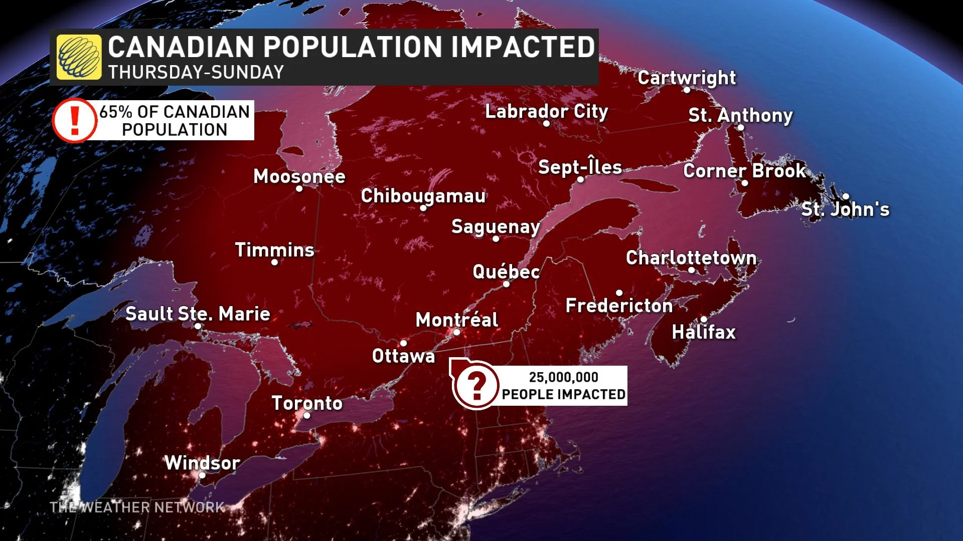
Millions will face impacts stretching for 3,000 km
In terms of its size, this storm will stretch a distance of 3,000 km – from the Gulf of Mexico to the shorelines of James Bay. It will bring rain, snow, ice and potentially damaging winds across this sprawl of land. A swath of heavy snow is expected to stretch from northern Texas, albeit light in nature, to the U.S. Midwest, Ontario and Quebec.
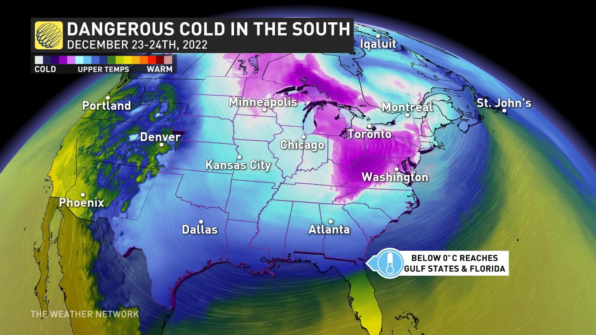
The storm may be 3,000 km in size from north to south, but the area in which temperatures will be below freezing will be even larger. Temperatures will drop below 0°C for the southern U.S., reaching all the way to the coast of the Gulf of Mexico and Florida...yes, even Orlando, Fla., won't be immune.
Dec. 24 will be a notable day for effects. For starters, more than 300 million people will wake up to temperatures below 0°C in North America.
There are several major impacts that millions of people in the U.S. and Canada should prepare for when it comes to this mammoth of a storm, including extremely dangerous driving conditions, power outages, damage to infrastructure due to high winds, flight cancellations and delays, as well as store and road closures.
It’s not just the roads that will be in rough shape. Air travel will be severely impacted as this system brings snow, rain and freezing temperatures to two of the top three largest airports in North America – in Chicago and Atlanta.
The active weather in Ontario and Quebec will start Thursday afternoon, with mostly rainfall expected across the region. This will remain the situation through Friday morning until the cold front arrives, which is when the storm will take a turn for the worse.
The National Weather Service (NWS) is pretty bold in its forecast wording for the event.
“An extremely amplified long-wave pattern during this period will spawn one of the most intense storm systems in decades to impact the Midwest and Great Lakes regions. This system will likely end up setting low-pressure records once it passes north of the border and will have the potential to generate storm-force winds over the lower Great lakes,” the NWS said in its Tuesday outlook.
The NWS is not holding back on its predictions for the storm, also saying “one could certainly describe this storm system as a once-in-a-generation-type of event.”

“Subtle differences remain, but there remains general model agreement in the overall large-scale scenario, which adds confidence,” NWS said. "Some of the parameters of this intense storm are climatologically 'off the charts.'”
Whether or not the scale of the storm comes to fruition remains to be seen, but one thing is for certain: There will be a lot of disruptions to holiday plans for millions of people who may not have a cheerful Dec. 25.


