Major Ontario storm threatens widespread power cuts, travel disruptions

A high-impact winter storm will target millions across southern Ontario Wednesday and Thursday, with significant icing, power outages and hazardous travel expected
A memorable and disruptive winter storm is shaping up across southern Ontario, with heavy snow and significant ice accretion expected to greatly affect travel and power lines. Ontarians are often impacted by Colorado lows, but this one in particular has forecasters especially concerned.
"Its easterly track over the Great Lakes, coupled with Gulf moisture and a winter versus spring-like temperature battle, all offer conditions ripe for prolonged, icy precipitation," warns Rachel Modestino, a meteorologist at The Weather Network. "Some regions may be impacted for over 20 hours, with dangerous winter travel expected for the Wednesday evening and Thursday morning commutes."
READ MORE: Ice & Snow: How to master the art of winter driving
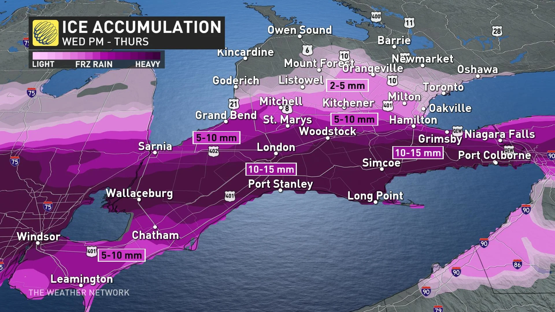
Southwestern Ontario: Threat for dangerous and prolonged freezing rain
The bull's-eye for the most significant freezing rain will be in southwestern Ontario -- from Windsor to the Niagara Peninsula. One of the most treacherous roadways will be Highway 3, north of Lake Erie. Beginning Wednesday evening, precipitation rates are forecast to increase into the overnight hours, lasting well into Thursday morning.
SEE ALSO: Here's how to stay safe during a winter power outage
Widespread winter storm watches and special weather statements are in effect for the prolonged period of freezing rain.
The amount of ice accretion will vary depending on surface temperature, wind speeds, and precipitation rates.
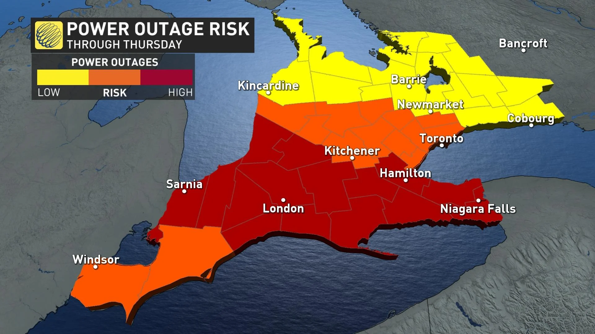
With winds gusting over 60 km/h, tree and power line damage risks are widespread, as well, with the threat for potential outages through Thursday.
RELATED: Is it a good idea to leave windshield wiper blades up before a snowfall?
Hazards to watch for in Ontario with this high-impact storm
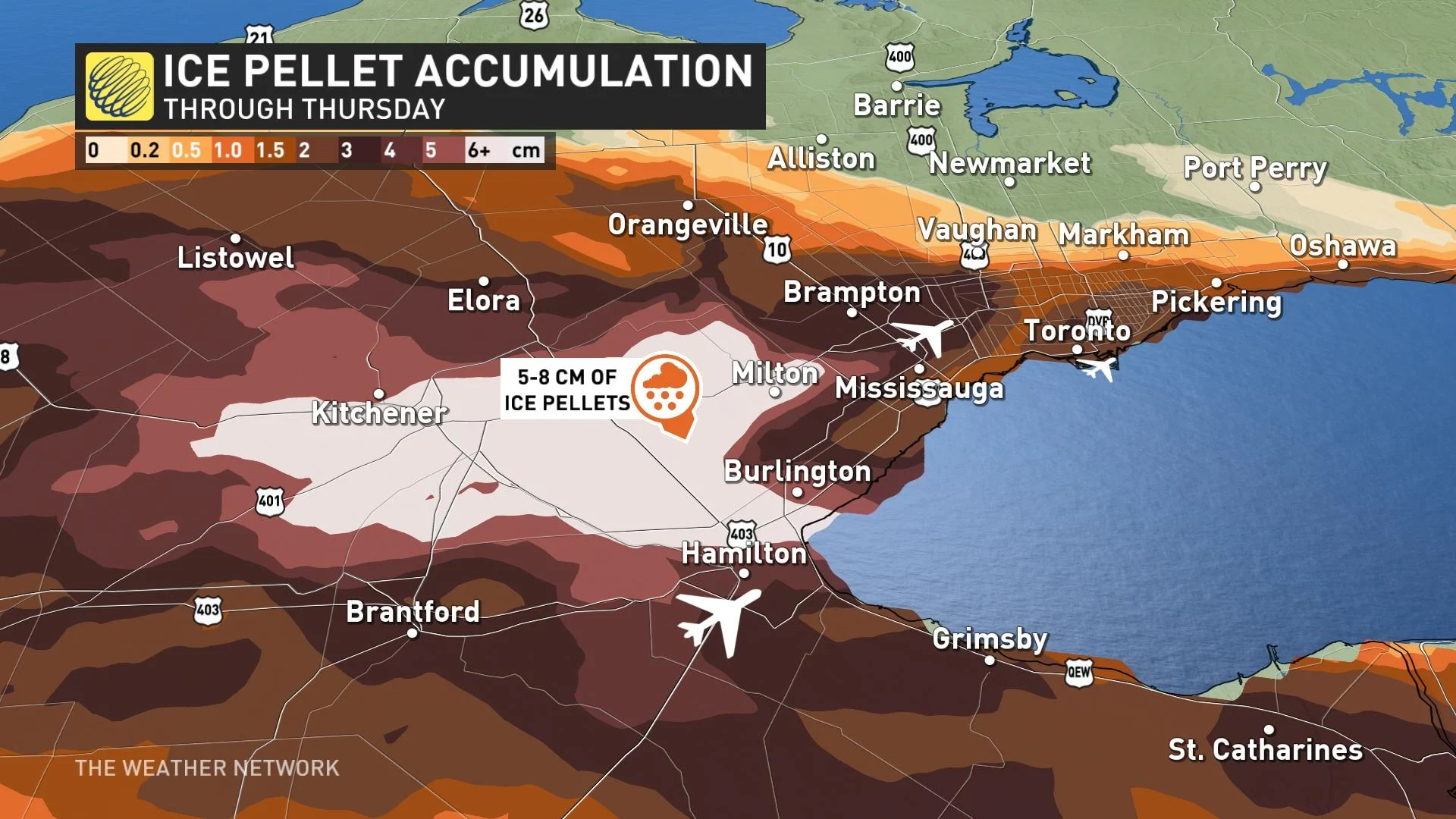
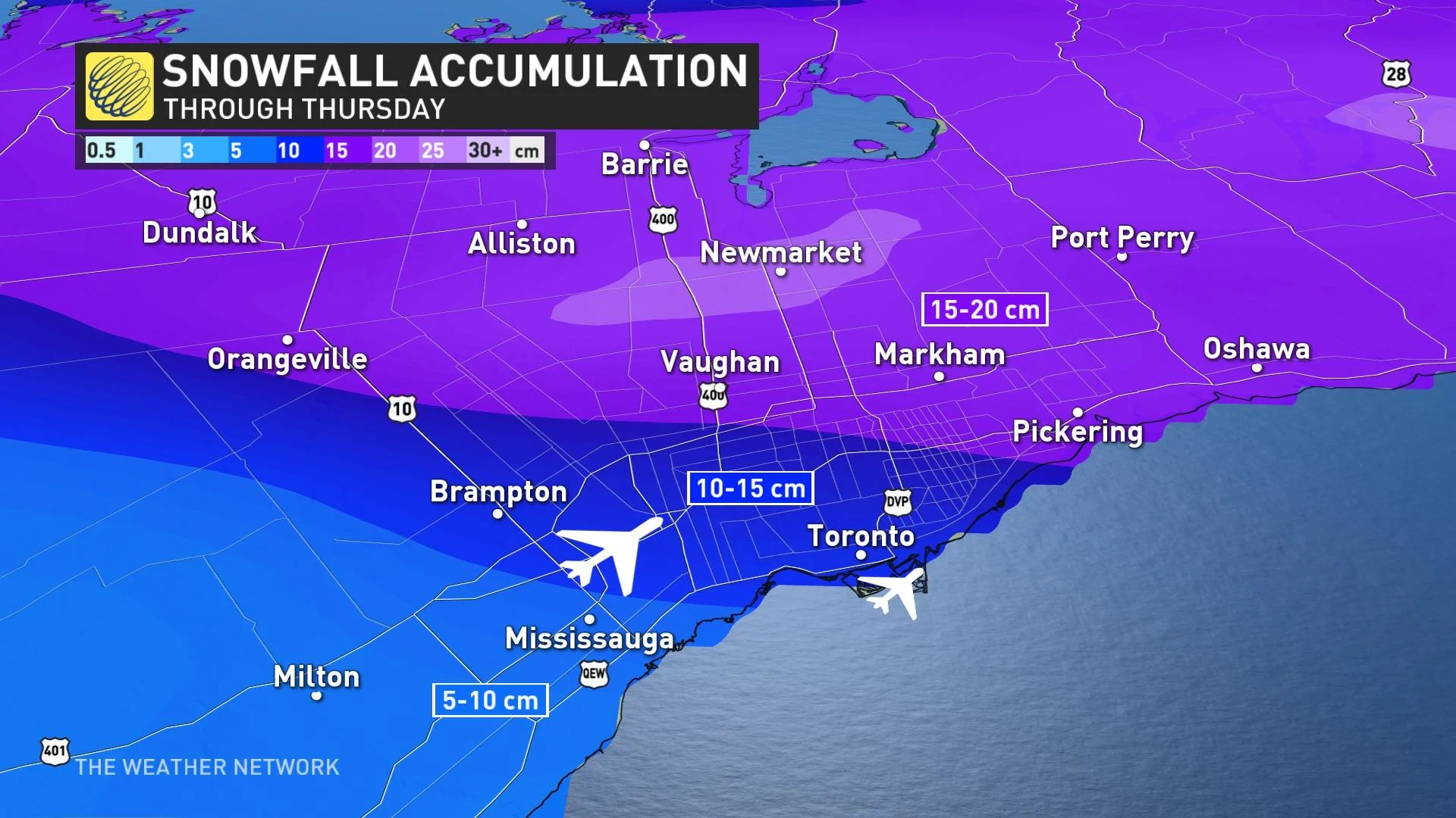
Greater Toronto Area: Threat for ice pellets and heavy snow
For the Greater Toronto Area (GTA), and regions to the north and east, there's more cold air funnelling in from the north. This creates a more shallow-melting layer, resulting in snow and ice pellet conditions.
Between 5-15 cm of snow is expected to kick off the winter storm event through the Wednesday evening commute. Then, snow will quickly transition to copious amounts of ice pellets, likely the most since April of 2018.
Ice pellets do not accumulate as readily as snowfall. They will still blow around and create slick surfaces, but are much less dangerous than freezing rain. Don't be fooled, however, as ice pellets are very heavy, which makes them more difficult to shovel.
There'll be a substantial amount of ice pellets wedged between the snow and freezing rain. Some areas across the GTA might see upwards of 10 hours of ice pellets as the dominant precipitation type.
They'll be some additional freezing rain on Thursday, adding more headaches for travellers and commuters.
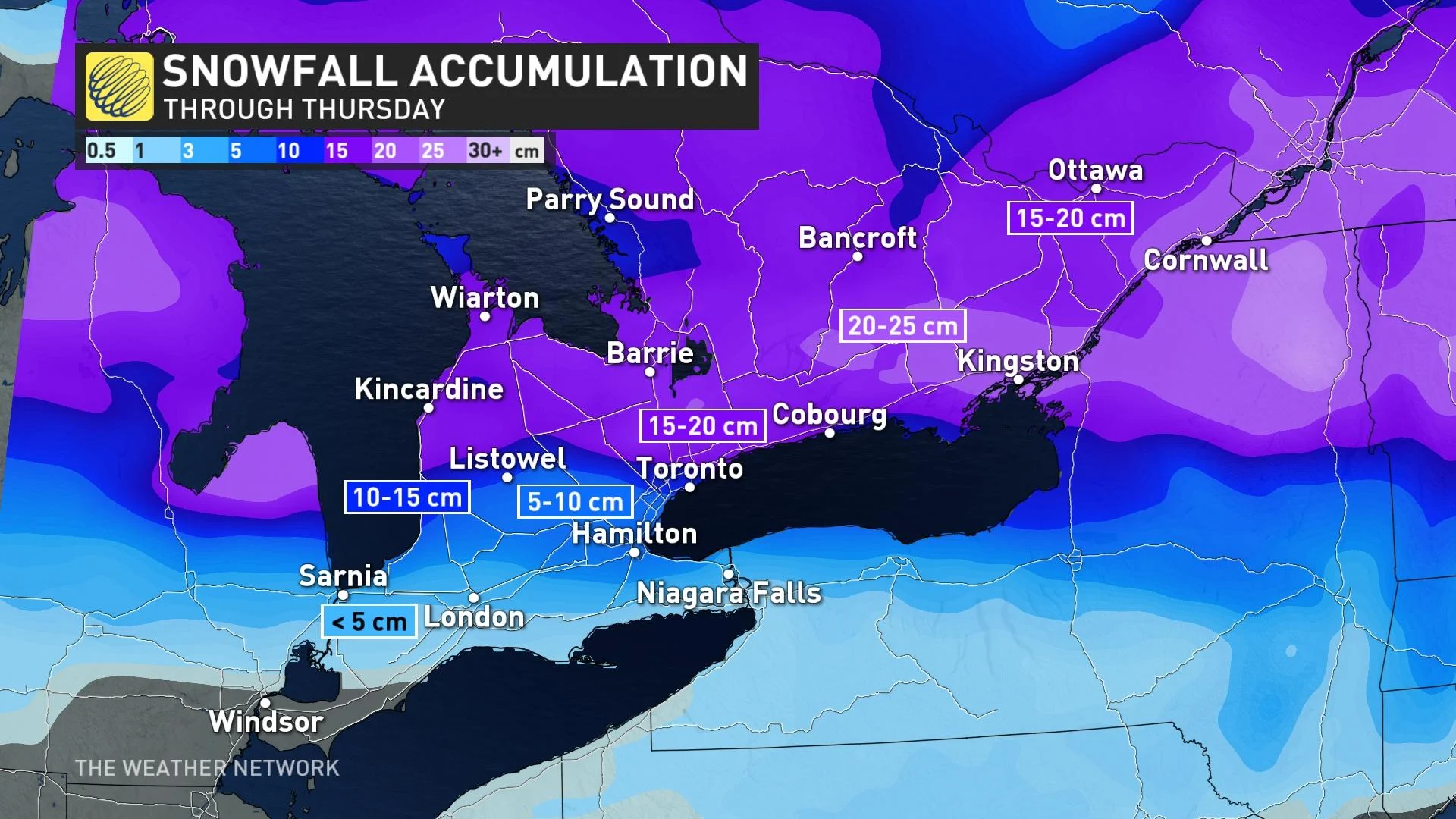
From the shores of Lake Huron to Kingston, and extending across eastern Ontario, there’s a higher probability to see over 20 cm of snowfall through Thursday.
Amounts start to fall off the closer to Quebec you travel, but even the Ottawa region is looking at upwards of 20 cm of snowfall with this low, as the region stays on the cold side of this storm.
The system is forecast to depart Thursday night and exit the region on Friday.
WATCH: Worried about a power outage? How to prep ahead of time
Stay tuned to The Weather Network for more forecast updates for Ontario. For information on emergency plans and kits go to http://www.getprepared.gc.ca.
Thumbnail courtesy of Getty Images/Alexei Korshunov.