
Brace for dangerous whiteouts in Ontario as winds pick up, more snow pushes in

There will barely be any clean-up time before the next system brings some additional snow and gusty winds to parts of Ontario Friday night.
A spell of wintry weather that saw southern Ontario wake up to a blanket of snow Friday morning will continue this weekend as a clipper system approaches the region. The system will bring additional snow and gusty winds into Saturday, which threatens blowing snow and dangerous whiteout conditions. More on what to expect this weekend and the active pattern we’re facing next week, below.
FRIDAY INTO SATURDAY: FRIGID CONDITIONS FOR SNOW CLEAN-UP, NEXT CLIPPER SYSTEM RIGHT ON THE DOORSTEP
The snow that fell overnight Thursday into Friday left a mess across southern Ontario. Slick roads led to hundreds of accidents across the region. Stay alert for slick roads and icy conditions across the region, especially as the sun goes down Friday evening.
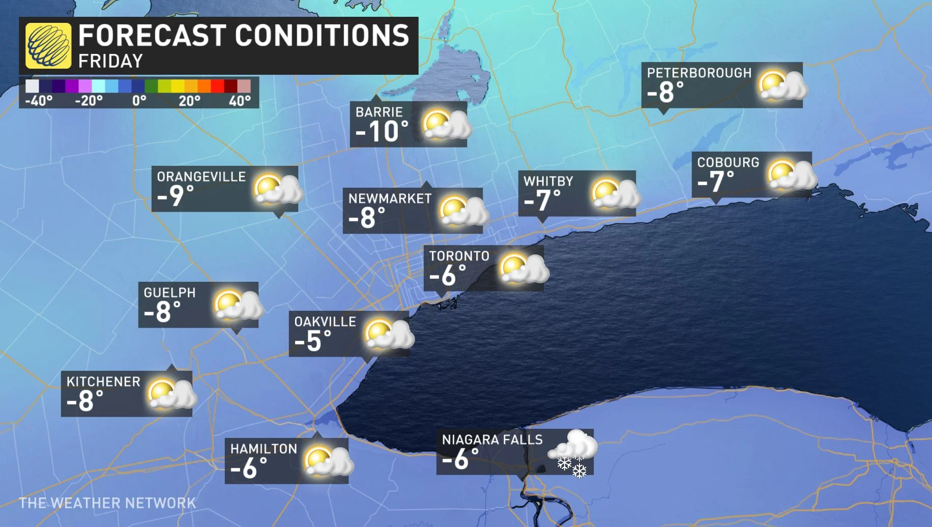
Conditions will remain well below seasonal through Friday, with temperatures lodged firmly in the minus single digits for most of southern Ontario, and a daytime high hovering around the -10°C mark around Ottawa.
ADDITIONAL SNOWFALL AND THREAT FOR DANGEROUS WHITEOUTS WITH GUSTY WINDS
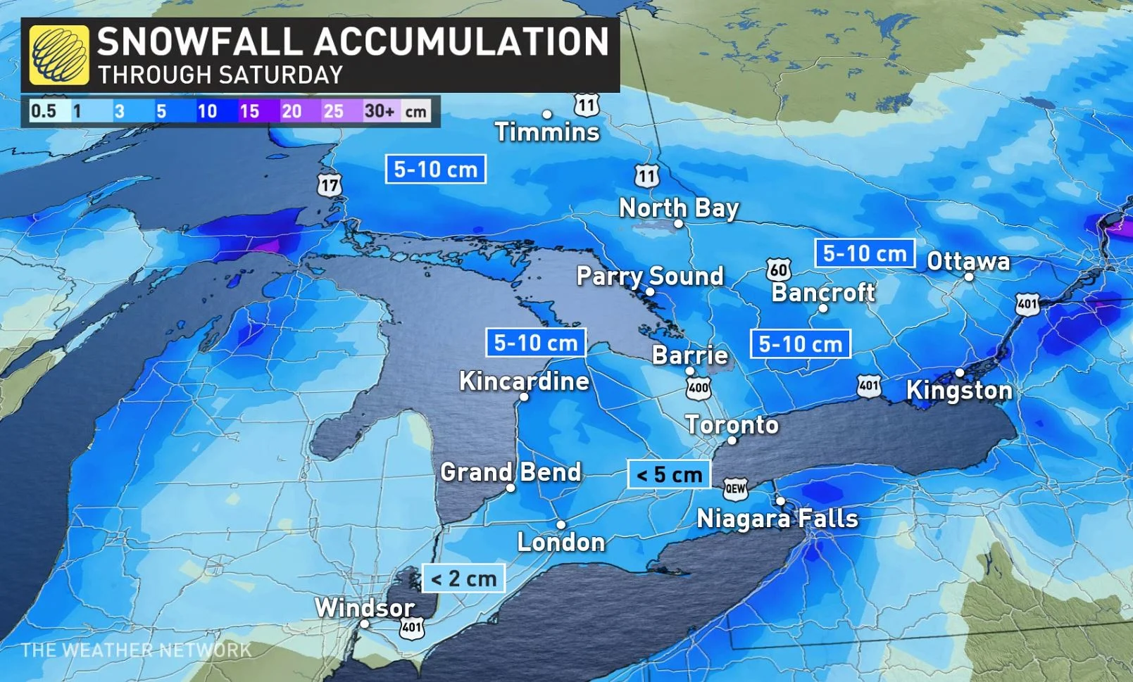
An incoming clipper system late Friday night will bring a quick 5-10 cm of snow to central Ontario and along the shores of Lake Huron and Georgian Bay through Saturday morning. Only a few centimetres however, are expected for the GTA this time around.
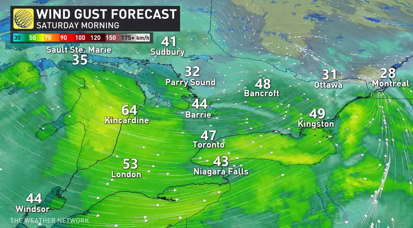
"Winds will also increase late Friday into Saturday however, with widespread wind gusts of 50-70+ km/h creating reduced visibility due to blowing snow that has recently fallen, and also with the additional snow coming with the clipper system," warns Kelly Sonnenburg, a meteorologist at The Weather Network.
Periods of snow are expected to continue through Saturday in the wake of the clipper, as northwest winds develop and create some lake-effect snow as well.
Temperatures will dive into the mid double-digits below zero overnight Saturday into Sunday, with lows by Sunday morning bottoming out around -14°C in Toronto and a frigid -20°C in Ottawa.
IT WAS A 'VERY WILD WEATHER DAY' SAYS TWN STORM CHASER
SUNDAY AND BEYOND: MESSY, ACTIVE PATTERN RETURNS TO ONTARIO NEXT WEEK
Ontario will feel the influence of a ridge of high pressure building over the eastern half of Canada by Sunday, allowing high temperatures in southern Ontario to climb back above freezing for the day on Sunday and the holiday on Monday. Highs in the low to mid single digits will aid with any remaining snow cleanup efforts.
We’ll see a familiar pattern return to Ontario by the middle of next week. A surge of cold air from the Prairies will encroach on the warmer ridge built over the region, putting Ontario squarely in this atmospheric battleground between warm air to the south/east and cold air to the north/west.
We could see two high-impact, moisture-laden storms across the region next week. It’s still far too early for details, but keep the threat for active weather on your radar as you make plans for next week, and check back frequently as our meteorologists refine the forecast and help you stay ahead of whatever heads our way.
Subscribe to 'This Day in Weather History': Apple Podcasts | Amazon Alexa | Google Assistant | Spotify | Google Podcasts | iHeartRadio | Overcast
Thumbnail image courtesy: Howard Berger - Vaughan, Ontario
Stay tuned to The Weather Network for the latest on the forecast across Ontario.


