Dynamic storm to blanket Maritimes with snow, ice, soaking rains
Brace for a wild weather weekend as an impactful system barrels towards the Maritimes, threatening to disrupt travel with freezing rain, heavy snowfall, and the risk of localized flooding
No rest for the weary across the East Coast who were hoping for a taste of spring instead of a retread of winter.
A dynamic storm sweeping into Atlantic Canada will deliver the whole spectrum of foul weather over the next couple of days, with 40+ cm of snow on tap for parts of New Brunswick as heavy snow blankets the province and western sections of nearby Prince Edward Island.
Soaking rains will target Nova Scotia for much of the storm, while some areas stuck between the two problem areas deal with ice accretion from steady freezing rain.
MUST SEE: Rare widespread chill to hit Canada, kicking off an active pattern
The smorgasbord of wintry weather will jeopardize travel plans throughout the region this weekend. Drivers are urged to plan ahead and stay aware of local road conditions before heading out.
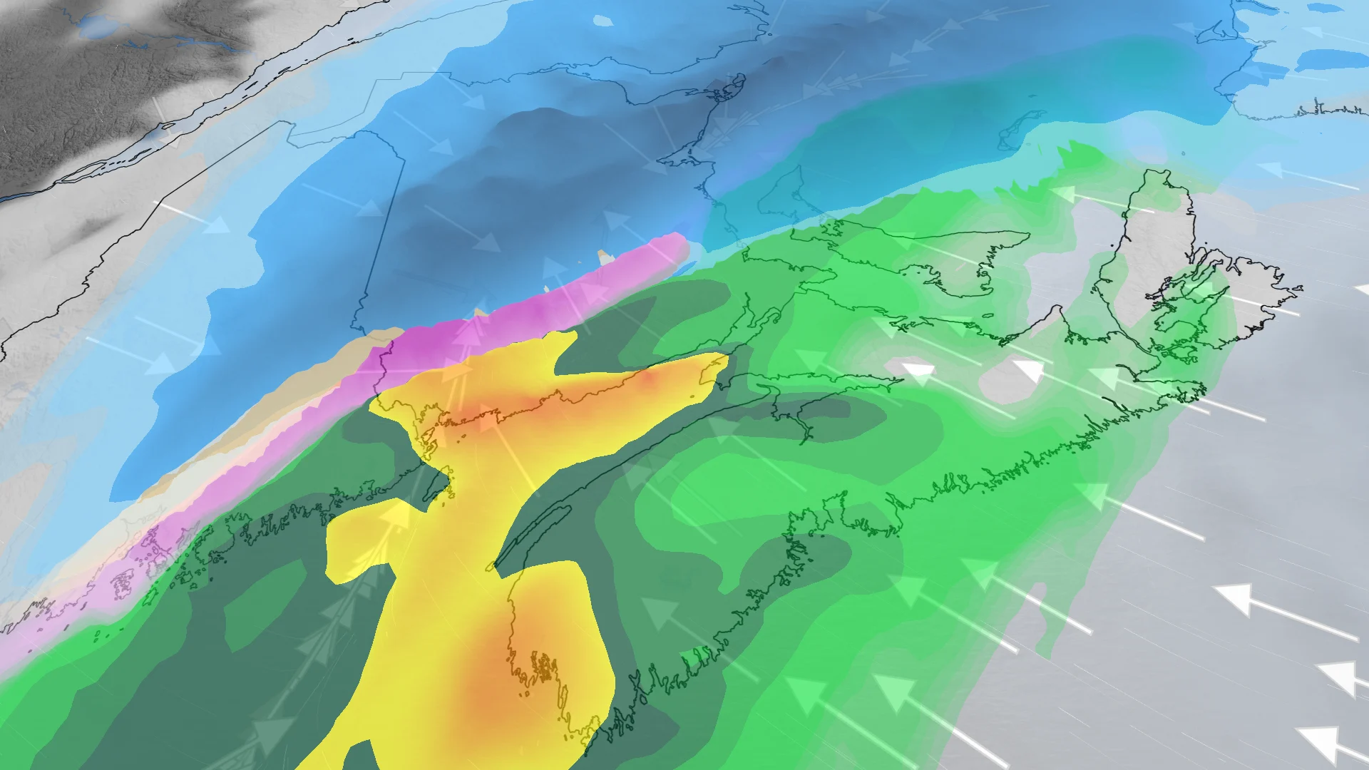
Saturday into Sunday: Heavy snow and rain spread across the Maritimes
A low-pressure system rolling in from the south will strengthen as it approaches the Bay of Fundy, scooping up subtropical moisture along the way.
The system begins with snow that’ll spread across the Maritimes from west to east on Saturday.

For northern and central New Brunswick, the precipitation will remain mostly heavy snow. The hardest-hit communities, including Fredericton, may see snowfall totals of 20-40+ cm by the end of the storm on Sunday. Fredericton’s normal March snowfall is 49.4 cm, so the region could see nearly a month's worth of snow with this weekend’s storm alone.
Widespread special weather statements are in effect for the province.
Through the overnight hours on Saturday, there is the chance for some mixing and ice accretion south of Fredericton and north of Saint John.

Exact ice accretion totals are uncertain at this time, as the track of the system could have an impact on precipitation types. The precipitation will change back to snow before gradually easing off through Sunday.
Drivers are being urged to plan ahead, and to adapt to the changing and rapidly deteriorating conditions. The heavy, wet snow and icy conditions could also heighten the risk for power outages.

Across Nova Scotia, the primary threat with this system will be heavy rain, with the risk for localized flooding in some of the heaviest hit areas. The rain will intensify through Sunday morning, with a brief period of mixed precipitation likely as the front slides out of the Maritimes.
By Sunday evening, most of the moisture will be confined to the southern coast of Nova Scotia, with between 30-50 mm of rain forecast through the weekend.

A couple more systems will bring unsettled weather for the second half of next week and into the weekend, with primarily rain and above seasonal temperatures forecast across the region.
Stay tuned to The Weather Network for the latest forecast updates for Eastern Canada.