Heavy snow blasts Prairies before polar vortex plunges region into deep freeze
A drastic change is coming in Western Canada, with significantly colder air moving in from the Arctic this week, but not before a bout of heavy snow blankets the Prairies
As the country grapples with winter storms, a blast of wintry weather is also ahead for the Prairies, bringing with it some of the coldest air of the season. So, it's time to bundle up and prepare for the chill.
Fluffy blowing snow continues to dump 10-25 cm along the Yellowhead Highway across the Prairies through Wednesday, followed by a dangerous cold snap. Temperatures in the -30's are forecast across Alberta, Saskatchewan and Manitoba to end off the week, a rare feat in an El Niño winter.
Snowfall Tuesday into Wednesday
As we move into Wednesday, the snow will reach Manitoba during the early hours of the morning and continue throughout the day in certain areas of the province. The heaviest amounts appear to be in the Dauphin area, where as much as 25 cm will be possible. Folks in Brandon could see 15-20 cm, while 5-10 cm is forecast for Winnipeg.
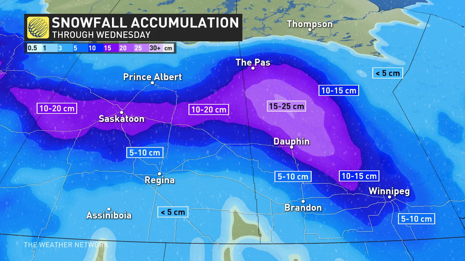
Environment and Climate Change Canada (ECCC) has issued snowfall warnings for Saskatoon and the surrounding area, as well as in Alberta, east of Edmonton. Further north for both provinces, ECCC has issued extreme cold warnings, which will likely spread further south later in the week.
Areas from Saskatoon to Regina will also be impacted early Wednesday as the storm moves southeast. Snowfall will linger over the Pas and Dauphin through the day and slowly sink further south. Winnipeg has the potential to see snow late Wednesday through Thursday , accumulating 5-10+ cm, heavier as you head north of the city.
SEE ALSO: What POP really means in a weather forecast
Now, here's a heads up for everyone in these three provinces. Once the system clears out on Thursday morning, temperatures are going to drop dramatically, reaching dangerously cold levels through the weekend. It's important to exercise caution and take necessary precautions to stay safe. More details on the cold below.
Extreme Cold
To think, later this week, daytime highs on the Prairies will struggle to go above -30°C –– an extremely rare feat during an El Niño winter.
Things are going to change in a hurry across the Prairies as a flip in the pattern opens the gates for frigid air to spill out of the heart of the Arctic Circle.
MUST SEE: What is the polar vortex? How it’s responsible for dangerous cold
The polar vortex will drive this rapid change in wintry fortunes across the western half of Canada. This large-scale circulation high above the Arctic acts like a fence, keeping the bitterest chill confined to the higher latitudes. When the polar vortex weakens and grows unstable, those frigid temperatures can spill south.
After the mild December where the coldest air in the Northern Hemisphere stalled over Siberia, the tables have turned. Now, the coldest temperatures relative to normal on the entire globe will be across British Columbia and the western Prairies.
DON'T MISS: Winter to finally show up in January as El Niño bested by polar vortex
A big temperature contrast is forecast on Tuesday as a low-pressure system tracks east. There will be a 30-degree temperature range across Alberta, as cold air begins to ooze farther south.
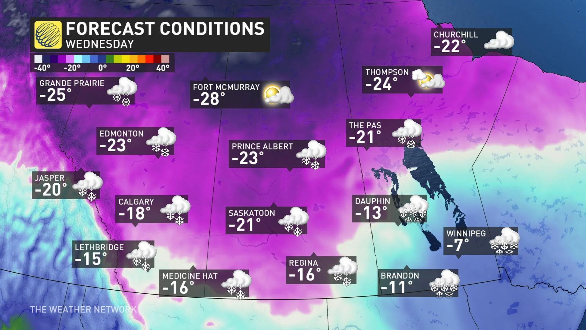
By Wednesday, the Arctic floodgates will have opened across the western Prairies, with temperatures diving well below seasonal.
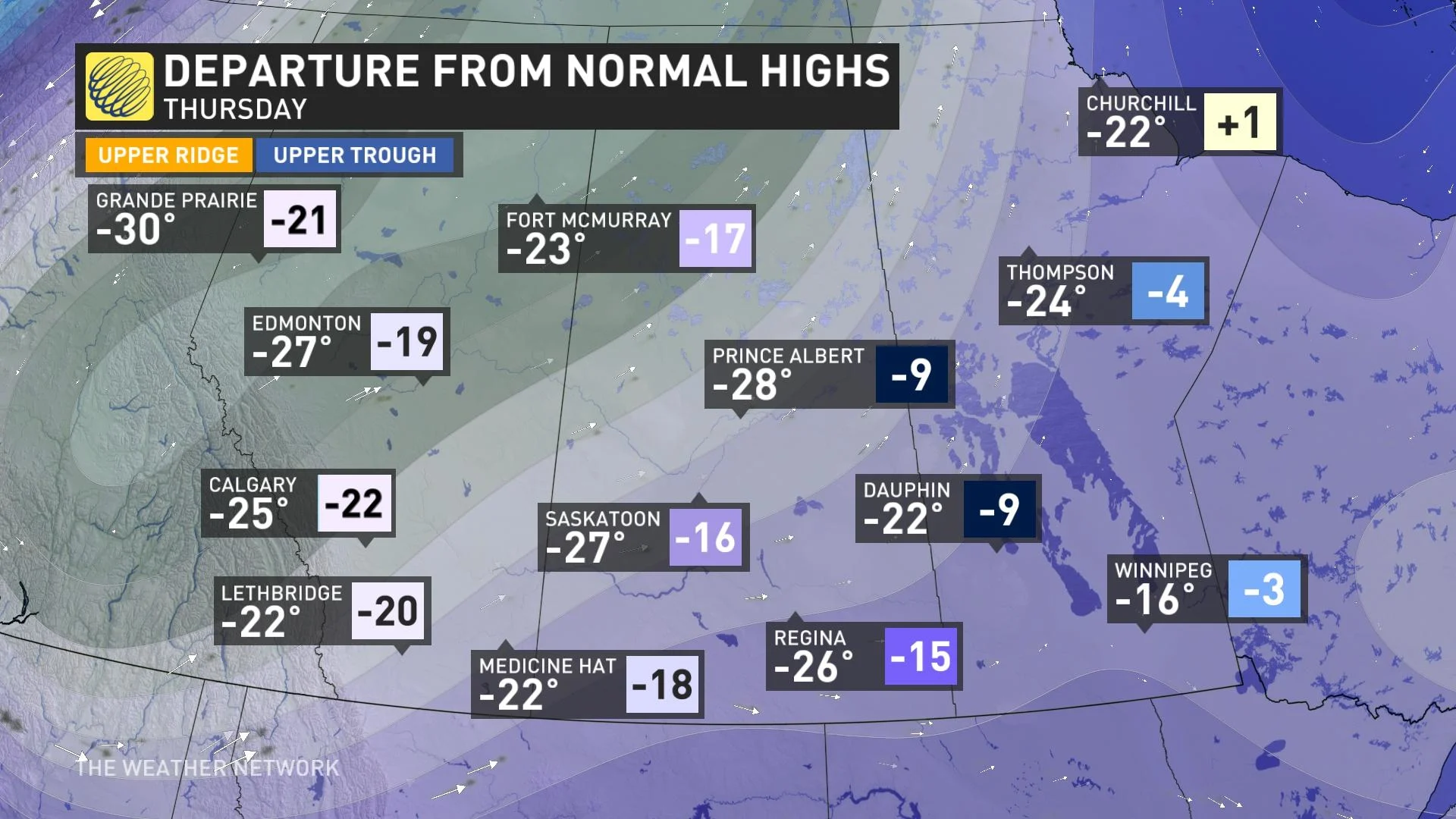
Temperatures continue to tumble to dangerously cold values on Thursday, here’s the temperature anomalies forecast to be more than 20 degrees below seasonal in Alberta.
MUST SEE: The chilling truth behind wind chill and its impact on our well-being
But it gets worse, somehow. It gets even colder on Friday as models are suggesting highs will struggle to get much above -30°C for daytime highs, a rarity in the 21st century. Edmonton airport has recorded just five days in the 21st century below -30°C as daytime highs –– the last time on Dec. 21, 2022.
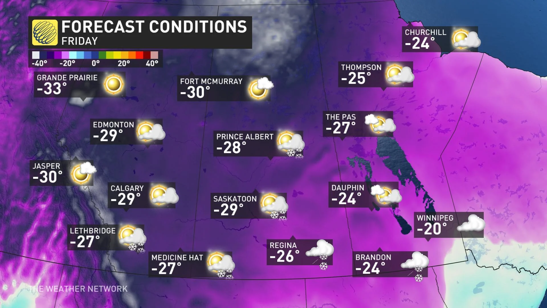
For Calgary, it’s even more rare. Just once since the year 2000 has it had a daytime high of -30°C, recorded on Jan. 27, 2004. The 20th century had 56 instances of a daytime high at or below -30°C, for reference.
Be Aware of Cold-related Emergencies
When a person is exposed to cold temperatures it may result in a decrease in body temperature, which is called a cold-related emergency.
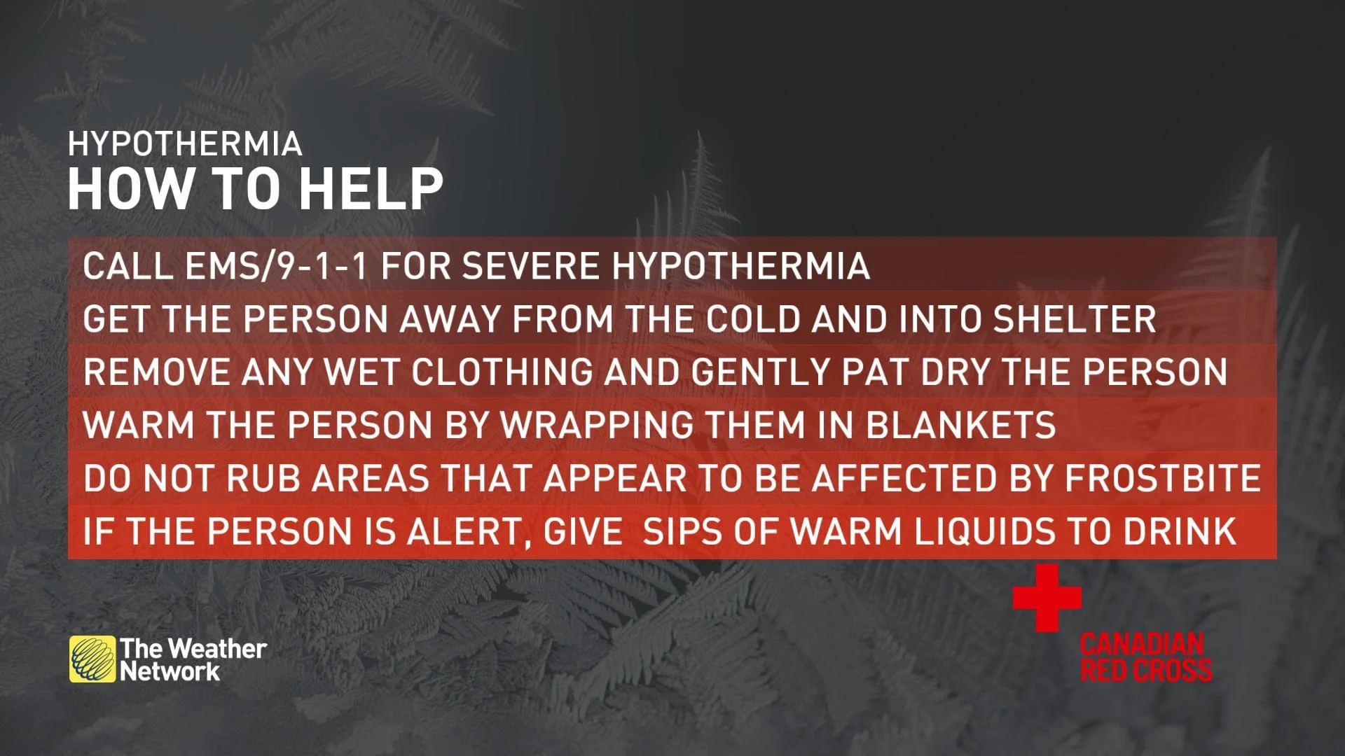
It is important for everyone enjoying the outdoors to know how to recognize when someone has been exposed to cold for too long, prevent cold-related emergencies, and be able to provide help when needed.
Prevention:
Cover your head and trunk by wearing a hat and layers of tightly woven fabrics such as wool or synthetics.
Cover up exposed areas such as your fingers, cheeks, ears, and nose.
If your clothes get wet when you are in the cold, change into dry clothes as soon as possible.
Drink plenty of warm fluids to help your body stay warm and hydrated, avoid caffeine and alcohol.
Eat high calorie food and drinks regularly as the body converts food to energy which heats the body.
Dress in layers so that you can adjust to changes as you heat up or cool off.
Bring additional warm clothing when going out for extended periods or in case of emergency.
Don’t wear tight fitting clothing or footwear that may impair circulation.
Seek shelter from the wind if you are getting cold, even if it is only behind a tree, hill, embankment, or other landscape feature.
You can find more information on how to recognize when someone is suffering from a cold-related emergency, here.
WATCH: Know the signs of frostbite and hypothermia this winter
Stay with The Weather Network for the latest on conditions across the Prairies.