Storms fire up across Ontario, relief from humidity comes next

More comfortable temperatures are set to make their return to Ontario, though accompanied by some storm risk Tuesday.
Days of extreme heat will come to an end shortly, with a cold front set to cross southern Ontario. But uncomfortable heat will linger somewhat for much of the day, especially in the sweltering east. As that front passes, however, it will trigger thunderstorms possibly reaching severe levels for much of the province. Details and timing, below.
Visit our Complete Guide to Summer 2020 for an in-depth look at the Summer Forecast, tips to plan for it and much more
WEATHER HIGHLIGHTS:
Daytime highs still feel above 30 Tuesday, closer to 40 in the east
Cold front will bring temperatures down as it passes in the afternoon and evening
More seasonal temperatures ahead
Keep on top of weather ALERTS in your area
TUESDAY: COLD FRONT TO BRING END TO HEAT, WIDESPREAD STORMS POSSIBLE
The first sign of a return to seasonal temperatures comes later Tuesday, with the passage of a cold front through the afternoon and evening hours.
However, with its late-day arrival, there will be plenty of daytime heat still left, most intense in eastern Ontario, where heat warnings are still in effect ahead of daytime highs feeling closer to 40 than 30.
Temperatures in the the GTA will also remain quite hot during the day, with humidex values making it feel like the mid-30s.

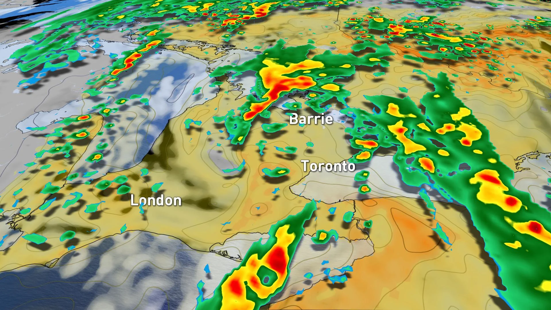
When that cold front does move through later in the day, it'll be cutting through the lingering soupy humidity, triggering a few thunderstorms through the afternoon and evening.
A large swath of Ontario has a slightly elevated risk of some of those storms turning severe. If so, such storms that do become severe will feature heavy downpours, small hail, and strong winds potentially reaching the 60 km/h mark.
Residents are advised to prepare to take shelter if severe weather strikes. You can find out more about the thunderstorm risk in the video that leads this article.

A possible tornado was captured on video on Tuesday afternoon in the Kawartha Lakes region, which can be seen in the tweet below. The video was taken at Sturgeon Point on Sturgeon Lake between Lindsay and Bobcaygeon. Rain and thunderstorms were tracking through the area during the time the possible tornado occurred.
LOOK AHEAD: HEAT EASES OFF MID-WEEK, BUT WILL RETURN NEAR MONTH'S END
There will be relief mid-week, once the cold front finally finishes cutting through the province Tuesday evening, cooling off temperatures and wiping out the humidity.
Temperatures on Wednesday will return to more seasonal values, though accompanied by some lingering pop-up showers in parts of southern, eastern Ontario, as well as cottage country, thanks to an upper-level low in the north.

Looking further ahead, we are watching the potential for a system to track across the region on Saturday, with a period of widespread rain and thunderstorms. While the timing is not ideal, this has the potential to bring widespread and much-needed rain to the region.
CANADA DAY SNEAK PEEK
An extended stretch of mid-summer heat and humidity will return to Ontario and Quebec for next week, including Canada Day. At this point, it looks like Canada Day will feature temperatures in the lower 30s with a humidex near 40, possibly into the lower 40s.
Stay tuned to The Weather Network for the latest forecast updates.