
One of the mildest Halloween's on record in southern Ontario, but with rain risk
Record-setting warmth, rain showers, and even snow! This Halloween forecast will have it all across Ontario
A 20-degree Halloween? Some may be double, and even triple-check the forecast as they step outside into what feels like some balmy, late-summer weather. There hasn't been a warmer Halloween in recent memory across southern Ontario, with most years requiring extra costume layering to avoid the typical end of October chill.
DON'T MISS: Halloween a treat for some with record heat, while some are in for a cool spell
But this year will feature some potential, record-breaking warmth, challenging records set from decades ago. In Toronto, the current record sits at 22.8°C, set on Oct. 31, 1971.
This Halloween, the forecast high for the city is 22°C, so it'll be an extremely close call for setting a new all-time record. Other major cities including London, Ottawa, and Sudbury could see their warmest Halloween's on record, as well.

Despite new, record-warm temperatures on the line, the Halloween forecast will still require some extra attention. A low-pressure system threatens some poorly timed rain showers just as trick-or-treaters take to the streets Thursday night.
Southern Ontario treated with some summer-like warmth this Halloween
An area of high pressure centred across the southeast U.S. has been pumping mild, humid air into Ontario this week.
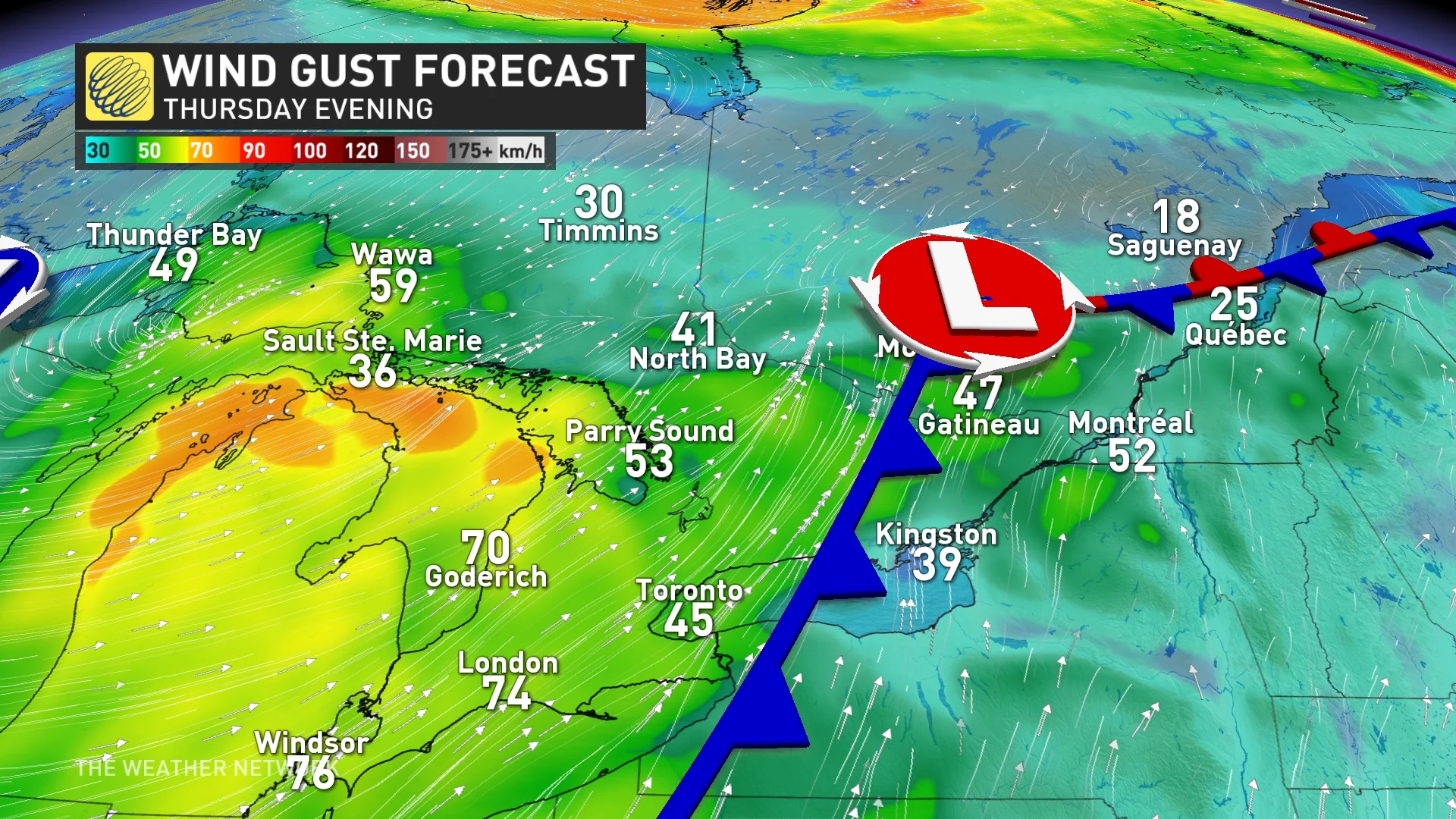
Temperatures will continue to climb from the mid to upper teens Thursday morning, to the low 20s by the afternoon across the south. A gusty, southwest wind will help to usher in the warmth, with wind gusts between 40-60+ km/h expected throughout the day.
RELATED: July-like warmth surges toward Ontario to end October
Temperatures will continue to hover around the 20-degree mark through Thursday evening, but as we approach the trick-or-treat hours, there will be the threat for rain showers as a cold front slides through.
Tricky rainfall timing
It's beginning to look a little more cautiously optimistic however, as showers may hold off for the early part of the evening. Areas south of the 401 corridor are most favoured for lighter showers and dry breaks.
Rain showers look more certain for the north end of the GTA and towards cottage country. That means you may need an umbrella or raincoat with the costume ensemble.

For sections of eastern Ontario, the timing may align better, as the rain pushes in from Kingston to Ottawa through the latter part of the night.
A general 5-10 mm of rain is expected across the south, with heavier totals possibly reaching 60 mm for the harder-hit areas in the north. Rainfall warnings are in effect for those regions. Snow and freezing rain have also prompted winter weather travel advisories across northeastern Ontario, with some areas in line to see 5-10+ cm of snow.

DON'T MISS: This epic mountain coaster offers breathtaking views of Ontario's fall colours
All trick-or-treaters will have to contend with the blustery winds as they trot from house to house. Halloween decorations may also be in jeopardy, with the strong gusts expected to last through the night.
By Friday, it's back to reality for everyone, with much more seasonal temperatures moving in behind the front. Daytime highs will remain in the single-digits to round out the week.
Changeable temperatures are expected during early November, though should tip to the warm side of seasonal.
DON'T MISS: What does a ‘missing’ La Niña mean for Canada’s winter?
An active pattern is likely for next week, as a couple of low-pressure systems will track north and west of the region. Windy conditions and mild temperatures will arrive ahead of the cold fronts, followed by a period of showers, and then brief shots of cooler, more seasonal temperatures.