Hail and torrential rain: Severe storm threat stretches across Ontario, Quebec
Scattered thunderstorms are expected to develop across parts of eastern Ontario and southern Quebec by Tuesday afternoon
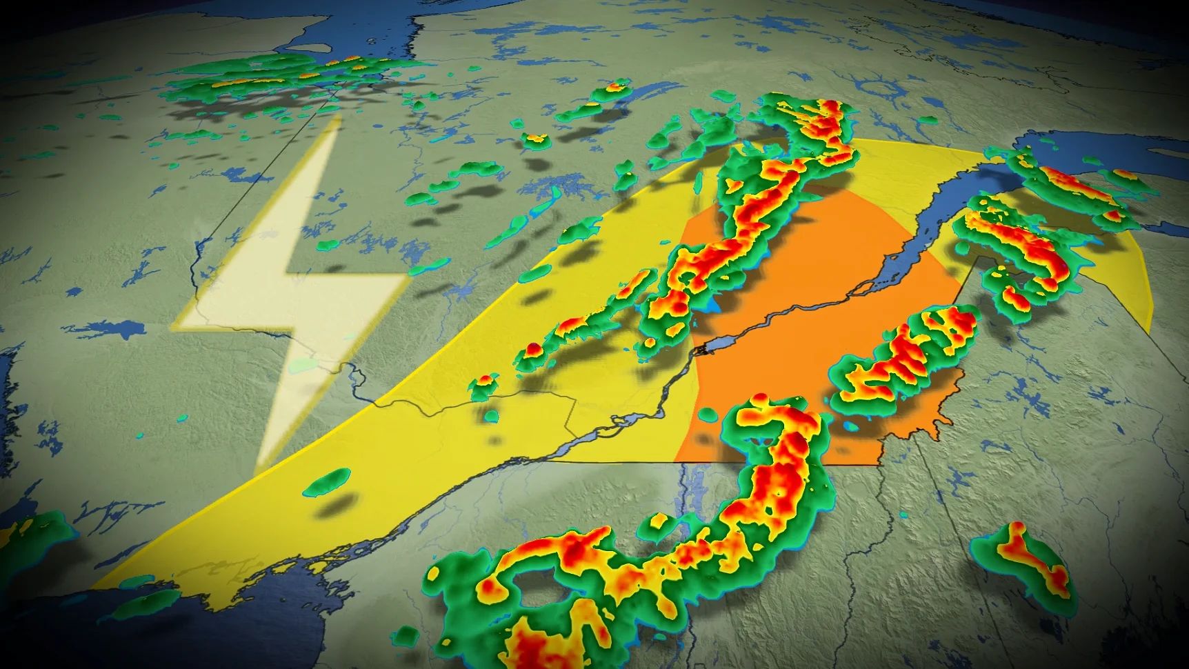
Parts of Ontario and Quebec are beginning the week with mild temperatures, however, a strong cold front is forecast to move southward across the region late Tuesday into Tuesday night, bringing showers and thunderstorms. Some storms may reach strong to severe levels, particularly in the Eastern Townships.
DON'T MISS: Canada spends the entire spring waiting for it to be spring
Widespread rain will develop Tuesday night and persist into Wednesday. Rainfall totals are expected to vary, with the heaviest amounts — between 20-50 mm — likely south and east of Montreal, especially in the Eastern Townships. Residents in these areas should stay updated as conditions develop.
Weather Highlights:
A slow-moving cold front will bring rain and a risk of thunderstorms Tuesday afternoon
Stronger storms could develop in the Eastern Townships and north of the St. Lawrence, posing risks of strong winds, small hail, and heavy rain
Southern Ontario will see scattered showers, with a chance of thunderstorms in the Niagara region
Eastern Ontario and southern Quebec
A slow-moving cold front sweeping through eastern Ontario and southern Quebec will bring rain and a risk of thunderstorms Tuesday afternoon and evening. Ahead of the front, temperatures in areas such as the Greater Toronto Area (GTA) will briefly climb into the mid-teens before dropping in its wake.

Thunderstorms are expected to develop during the early afternoon, with atmospheric instability, strong upper-level winds, and cooler air aloft supporting the potential for stronger storms.
Thunderstorm activity will be most notable in the Eastern Townships and north of the St. Lawrence, including areas near Quebec City.

Primary risks include strong wind gusts, small hail, and locally torrential rainfall. Thunderstorm activity will persist through the afternoon, tapering into the early evening.
Southern Ontario
Southern Ontario can expect isolated to scattered rain showers Tuesday, with the Niagara region at slight risk for an embedded thunderstorm.

By Tuesday night, a secondary push of moisture may bring additional rain to communities along the shores of Lake Erie and Lake Ontario.
SEE ALSO: This Ontario getaway saves summer from over-planning
Late week outlook: Feeling like April again
Below-seasonal temperatures will arrive later this week, with a mix of sun and cloud and a chance of passing showers.

Temperatures cooler than seasonal norms are expected to persist through midweek and potentially into late next week. However, there is potential for a shift in the pattern, with a warming trend bringing temperatures back to at least seasonal averages during the long weekend and extending into the following week.
WATCH BELOW: Truths and myths about safety during a thunderstorm
Stay with The Weather Network for the latest across Ontario and Quebec