Wintry mess of snow, ice, and winds blast through Ontario
More ice accretion and gusty winds could lead to additional power outages across hard-hit regions in Ontario on Wednesday
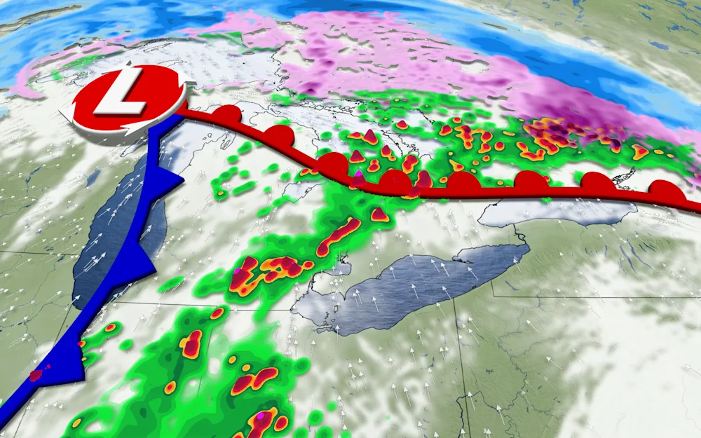
Another impactful storm system is on the way for much of Ontario this week, threatening the entire spectrum of active weather from freezing rain to thunderstorms.
More than 200,000 customers remain without power from this past weekend’s ice storm. While we are not forecasting another ice storm, additional outages are possible with this latest round of freezing rain and wind.

MONTHLY OUTLOOK: April’s wild side will show its true colours across Canada
Slick commute home for Greater Toronto and Hamilton Area
A patchwork of warnings covered Ontario on Wednesday, including rainfall warnings in the southwest, freezing rain warnings through eastern and central regions, and snowfall warnings across the north.
The activity arrives courtesy of a Colorado low moving into the province beginning Wednesday morning and lasting into Thursday morning.

DON'T MISS: Get to know the hidden gems across Canada
The Greater Toronto and Hamilton Area (GTHA), London, and Barrie will see temperatures hovering around the freezing mark for much of the afternoon. This will promote an initial burst of snowfall and freezing rain around lunchtime on Wednesday.
We could see around 3-5 cm of snow and 2-5 mm of ice accretion from this batch of wintry precipitation. Prepare for a messy commute home on the 401 and 400.
Wintry precipitation and slick driving conditions could continue until around the 3:00 p.m. hour when warming temperatures will force a changeover to very heavy rainfall.
More freezing rain for hard-hit areas
Farther north, hard-hit communities across cottage country and into eastern Ontario will see an initial burst of snow beginning late Wednesday afternoon and lasting into the evening. Accumulations should amount to about 5-10 cm in these regions.

RELATED: Freezing rain and ice pellets are dangerous winter hazards
We’ll see precipitation change over to freezing rain through the evening hours, bringing 2-5 mm of ice accretion. This will be much different from this past weekend’s ice event. We’re only expecting 3-6 hours of freezing rain this time around, and ice will have a harder time accreting given the heavy precipitation rates and gusty winds.
WATCH: Freezing rain again in Ontario, three key differences from the weekend storm
Even though this won’t be as bad as our last round of ice, residents should prepare for additional power outages given the fresh glaze of ice combined with gusty winds.
Rain in the southwest, heavy snow to the north
Folks on the consistently cold side of this Colorado low will deal with a hefty dose of April snow. Forecasters expect 20-30 cm of accumulation across northern Ontario, including Thunder Bay, where temperatures will remain chilly throughout the storm.

Meanwhile, consistently warm temperatures over southwestern Ontario will raise the risk for thunderstorms and flooding as a slug of heavy rain washes across the region.
A swath of the region is in line for 40-60+ mm of rainfall through Thursday, which could rival the wettest April day on record in some areas.
Be sure to check back for the latest weather updates across Ontario.