Freezing rain warnings as two wintry systems hit Newfoundland
Several hours of freezing rain in southeastern Newfoundland could make roads slick and threaten isolated power outages across the region
It’s been a rough stretch for storms across Newfoundland, and the latest bout of wintry precipitation hitting the island could bring enough ice to snarl travel and bring down trees and power lines.
Two rounds of winter weather will roll across Newfoundland through Saturday, with freezing rain the predominant disruption from each system.

Freezing rain warnings cover southeastern Newfoundland as our first round of freezing rain spreads over the region and persists into Friday morning. A second system will shift the threat for icy conditions to western Newfoundland heading into Saturday.
Prepare for slick roads and sidewalks during and after periods of freezing rain, and look out for potential tree damage and power outages in areas that see significant ice accretion.
MUST SEE: Snow little time: N.L. residents dig out from snow after compounding snowfall
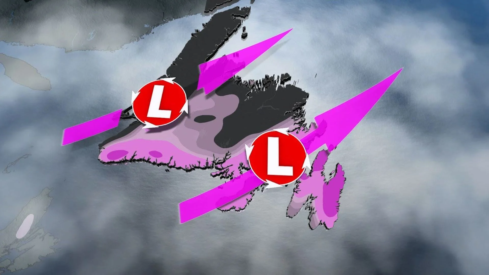
Round one continues into Friday morning
We’ve got a classic icy setup over Newfoundland to end the week. A low-pressure system approaching from the south is running into cold air locked in at the surface.
Temperatures are cold enough for snow to fall inland toward Gander and Badger, where 5-15 cm of snow will fall through Friday morning.

Milder temperatures closer to the centre of the storm will force precipitation to fall as a period of freezing rain across the Avalon, Bonavista, and Burin peninsulas.
Environment and Climate Change Canada (ECCC) issued a freezing rain warning for much of southeastern Newfoundland through early Friday morning as a result of the icy threat.
“Surfaces such as highways, roads, walkways and parking lots will become icy, slippery and hazardous,” ECCC said in its warning. “Utility outages may occur.”
SEE ALSO: Atlantic ‘hurricane alley’ sees ominous mid-July heat in February
Freezing drizzle began in St. John’s on Thursday evening, and forecasters expect freezing rain to spread across southeastern Newfoundland into the overnight hours. Precipitation should begin to transition from freezing rain to plain rain across the Avalon overnight, but slippery conditions will likely persist on exposed and untreated surfaces into Friday morning.

We can expect precipitation to end by Friday morning as this first round moves out of the region.
Ice accretions of 5-10 mm are expected across eastern and northern portions of the Avalon Peninsula, including St. John’s, as well as toward Clarenville and portions of the Burin Peninsula. Widespread ice totals of 2-5 mm are expected for the rest of the Burin and Bonavista peninsulas through Friday morning.
Remain mindful of trees looming over roofs, driveways, and streets as ice builds up on limbs and power lines. Plan to take it slow on the roads through Friday morning, and use extra caution on bridges as elevated surfaces are the first to ice over during wintry precipitation.
Round two arrives early Saturday
A second system pushing into Atlantic Canada early Saturday will take a track a bit farther to the west than our first round, pushing the threat for wintry precipitation into western Newfoundland.
Snow will begin overnight in southwestern Newfoundland, eventually changing over to a brief period of freezing rain and ice pellets.

Several millimetres of ice accretion is possible before warmer temperatures take hold and precipitation transitions to rain. This rain could be heavy at times, especially across the Burgeo area.
Milder conditions across southeastern Newfoundland will allow precipitation to remain all rain as the precipitation spreads east through Saturday evening.
This second and final round of precipitation will end by Sunday morning as the system pulls away.
Stay with The Weather Network for all the latest on your forecast across Newfoundland.