
Fred enters the U.S. as two more Atlantic storms eye impacts to land

Southeastern U.S., Bermuda, and hard-hit Haiti are bracing for impacts from three different tropical systems this week.
Forecasters are keeping a close eye on two Atlantic systems this week and a third that made landfall in Florida Monday afternoon.
Fred, Grace, and the newly minted Henri will all pose a threat to land over the next couple of days. Flooding from Tropical Depression Grace is a particular concern in Haiti, which is reeling from a major earthquake on Saturday. More on the tropical threats, below.
FRED MAKES LANDFALL IN FLORIDA WITH GUSTY WINDS, HEAVY RAIN
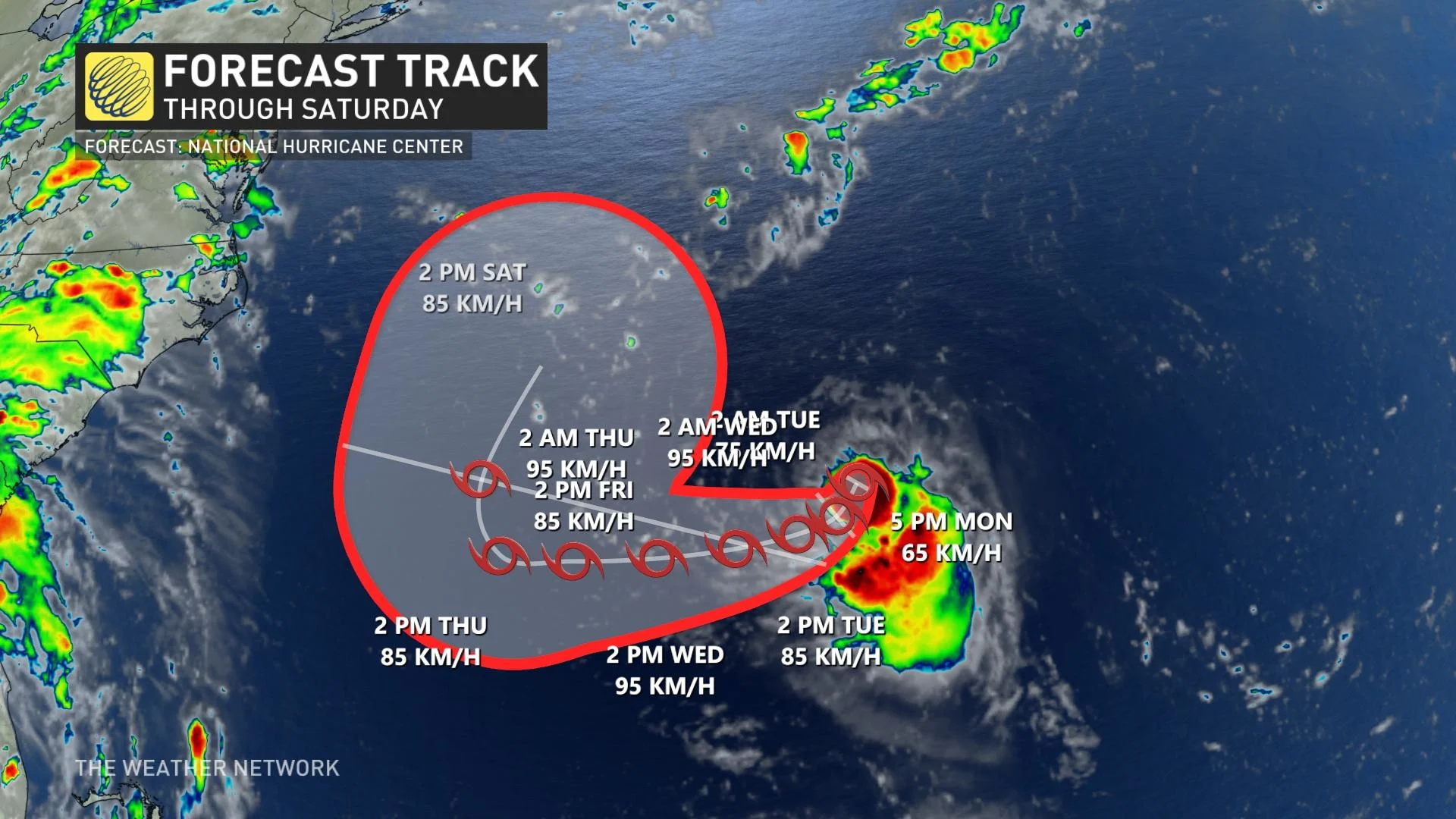
Tropical Storm Fred made landfall in Florida on Monday afternoon, according to the U.S. National Hurricane Center (NHC). At 3:15 p.m. EDT, the centre of Fred came onshore near Cape San Blas, Fla.
However, now that it has made landfall, rapid weakening is expected and Fred should become a tropical depression by early Tuesday.
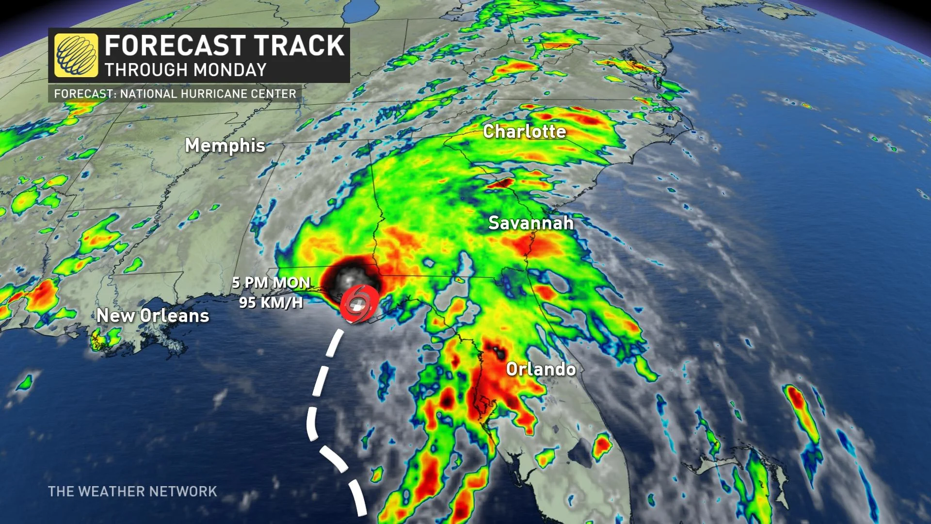
The latest advisory from the U.S. National Hurricane Center (NHC) shows Tropical Storm Fred is currently 35 km northwest of Apalachicola, Fla., with maximum sustained winds near 95 km/h with higher gusts. The storm is moving north-northeast near 15 km/h.
On the forecast track, Fred will move from western Georgia on Tuesday across the southern Appalachian Mountains to west Virginia by Wednesday.
Tropical storm force winds are likely across the Panhandle and portions of Alabama and Georgia as the storm pushes further inland.
A storm surge of 0.91-1.52 m above ground level is possible along the coast between Indian Pass and the Steinhatchee River if Fred’s landfall coincides with high tide.
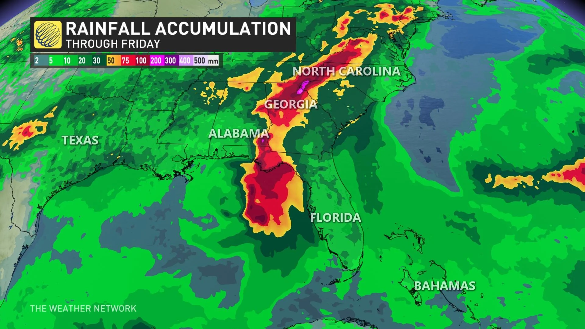
Heavy rain is a major concern as Fred moves inland. Many communities could see more than 100 mm of rain by the end of the storm, which will lead to a threat for flash flooding.
The threat for heavy rain and flash flooding will stretch into the mid-Atlantic states through Wednesday as Fred’s tropical moisture interacts with high terrain and a stalled front over the region.
A few tornadoes are possible Monday night across parts of the Florida Panhandle, southwest Georgia, and southeast Alabama. The tornado threat will shift northward into parts of northeast Georgia, the western Carolinas, and southern Virginia on Tuesday.
TROPICAL DEPRESSION GRACE APPROACHES HARD-HIT HAITI
Tropical Depression Grace struggled earlier Monday, but is expected to strengthen over the northwestern Caribbean Sea.
The storm is expected to impact communities in southwestern Haiti that were devastated by this weekend’s powerful 7.2-magnitude earthquake.
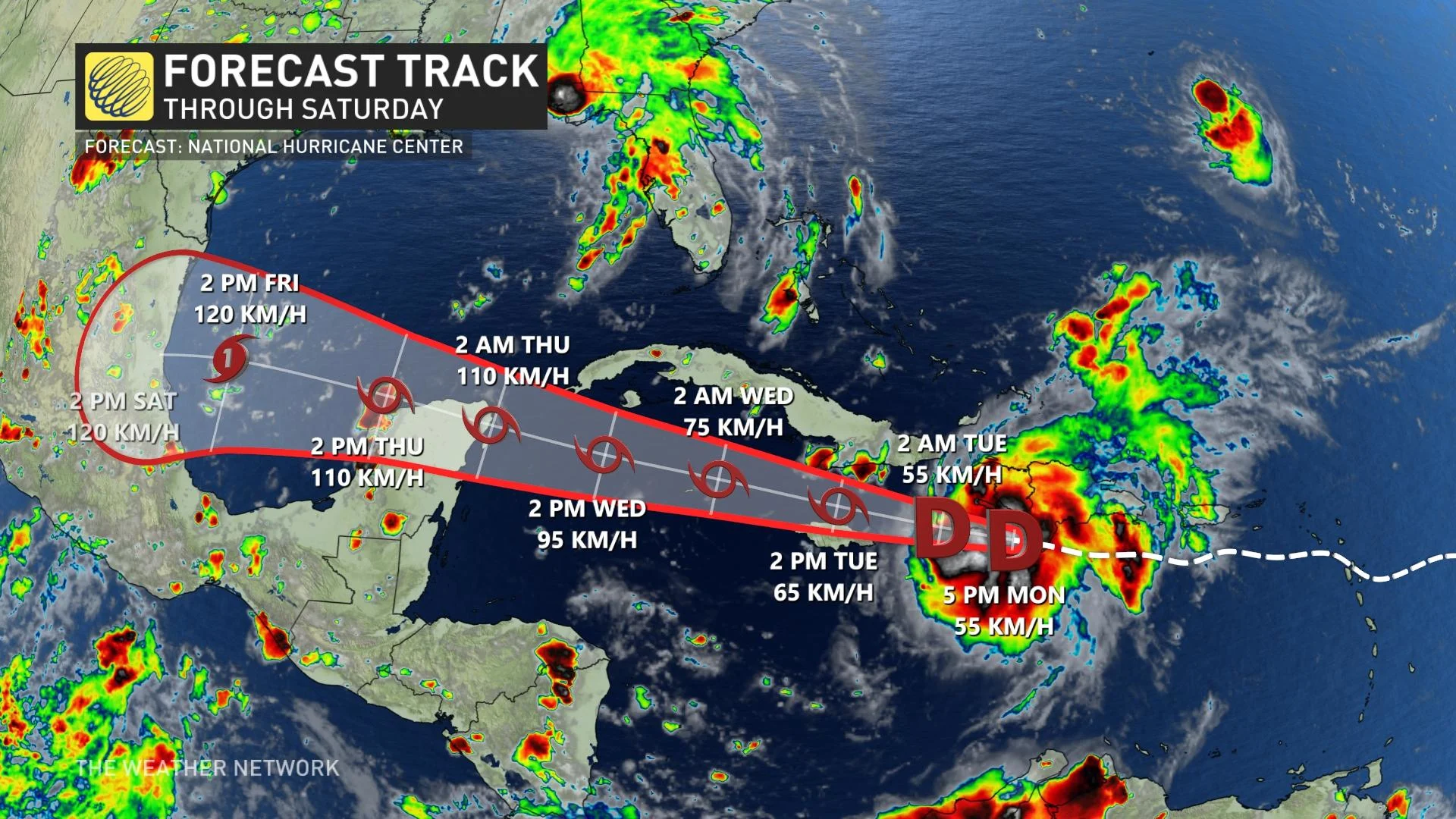
Its maximum sustained winds are near 55 km/h, with higher gusts. Strengthening is forecast during the next few days, and it is expected to regain tropical storm status on Tuesday. Grace could be near hurricane strength when it approaches the Yucatan Peninsula of Mexico Wednesday night.
Grace will move near the Tiburon Peninsula of Haiti through Monday night, move between Jamaica and southeastern Cuba on Tuesday, near the Cayman Islands Tuesday night, and approach the Yucatan Peninsula of Mexico Wednesday and Wednesday night.
Flooding is always a significant concern when a tropical cyclone affects the mountainous islands of the Caribbean.
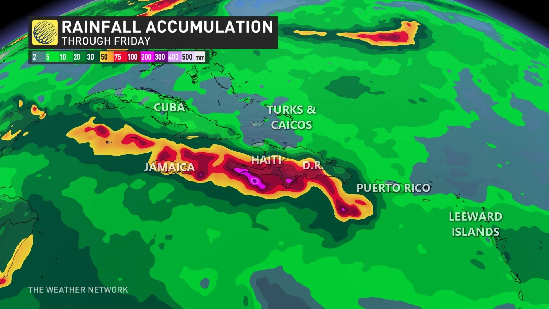
Rainfall totals of 125-250 mm are possible in Haiti and the Dominican Republic, with isolated totals of 350 mm possible on the southern part of the island. This heavy rainfall may lead to flash and urban flooding, and possible mudslides.
Southern Cuba, Jamaica and the Cayman Islands, could see 50-100 mm of rain, with up to 150 mm in isolated spots are possible, as Grace passes the islands this week. This heavy rainfall may lead to flash and urban flooding.
HENRI WILL BRING RAIN, WIND IMPACTS TO BERMUDA
Tropical Storm Henri took form in the Atlantic Ocean late Monday afternoon. Forecasters are expecting it to stay south of Bermuda, but the Caribbean country may still see some rain and wind impacts Tuesday.
It is currently 230 km southeast of Bermuda, moving south-southwest near 11 km/h. Its maximum sustained winds have increased to near 65 km/h with higher gusts. Some additional strengthening is forecast during the next couple of days.
On the forecast track, the centre of Henri should pass well to the south of Bermuda late Tuesday or Tuesday night. Tropical storm conditions are possible across Bermuda and the nearby waters on Tuesday, particularly to the south of the island.
A tropical storm watch is in effect for Bermuda.
At this time, it appears unlikely that the system will have any impacts in Atlantic Canada.
TROPICAL MOISTURE FROM FRED COULD MAKE ITS WAY INTO PARTS OF CENTRAL CANADA
However, the remnants of Tropical Storm Fred could throw a wrench in the forecast for Central Canada later this week. The system’s remnant moisture will travel through the eastern United States over the next couple of days, eventually reaching Ontario and Quebec by late week.
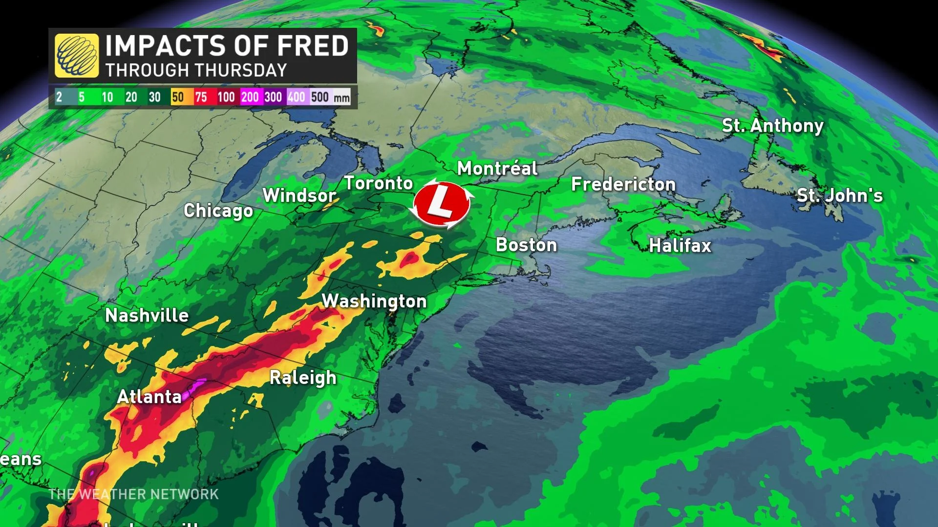
The surge of tropical moisture will bring a risk for scattered showers and thunderstorms with localized downpours, but there will be periods of sunshine in between the unsettled weather.
Stay tuned to The Weather Network for the latest updates on the tropics.