
Heavy rain precedes dangerous flash freeze in Atlantic Canada

Heavy rain and blustery winds through Friday will precede a sudden temperature drop that will freeze hard any standing water. This flash freeze will make driving and walking dangerous.
An unpleasant stretch of soggy, blustery weather will sweep across a vast swath of Atlantic Canada through the end of the week as a dynamic storm reaches Eastern Canada. The system’s heavy rain and high winds will push across the provinces through Friday morning. Snow will pile up in the northern Maritimes and western Newfoundland. We’ll see a flash freeze behind the system, which could make travel dangerous Friday and Saturday. More on the timing and impacts, below.
MUST SEE: Common household items that combat snow and ice
MARITIMES
Rain will continue across the Maritimes overnight Thursday into Friday. The precipitation will pick up in intensity by Friday morning, accompanied by gusty winds that could toss around loose objects and make it hard to keep a grip on the steering wheel.
An array of warnings are in effect for the Maritimes, including rainfall warnings, wind warnings, and flash freeze warnings.
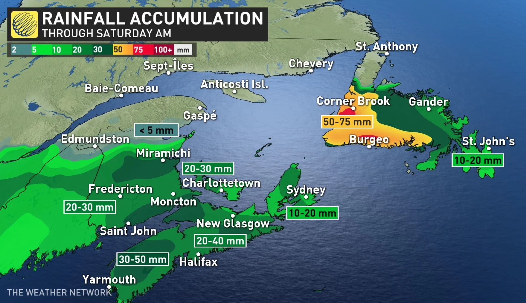
We’ll see anywhere between 20-50 mm of rain throughout the Maritimes, with higher totals likely in some spots.
As temperatures begin to dip behind the cold front, the rain will taper to flurries or ice pellets Friday afternoon and end in the evening. There is a risk of a brief period of freezing rain during the changeover.
Storm drains, gutters, and downspouts should be cleared in preparation for rain and melting snow as significant runoff is possible.
WATCH | POTHOLES WILL BECOME A BIGGER ISSUE IN HALIFAX:
Strong winds of 80-100 km/h, with higher gusts, will begin overnight Thursday and last into Friday. Residents are advised to bring in or secure any loose objects ahead of the system. Downed trees and power outages are also likely as winds pick up through the overnight into Friday.

By Friday afternoon, the temperature will drop quickly as the cold front moves north to south, which will lead to a flash freeze on surfaces such as roads, highways, walkways and parking lots. Plan for a slippery commute Friday evening.

NEWFOUNDLAND AND LABRADOR
Flooding will be possible as significant rain and runoff is expected for most of Newfoundland.
Southern and western Newfoundland could see as much as 50-90 mm of rain, with possibly more than 100 mm over higher elevation areas by Friday evening.
“Heavy downpours can cause flash floods and water pooling on roads,” cautions Environment and Climate Change Canada in a rainfall warning. “Localized flooding in low-lying areas is possible.”

Additionally, the weather agency has issued wind warnings for the area. The strongest winds will arrive on Friday, when gusts could reach about 110 km/h.
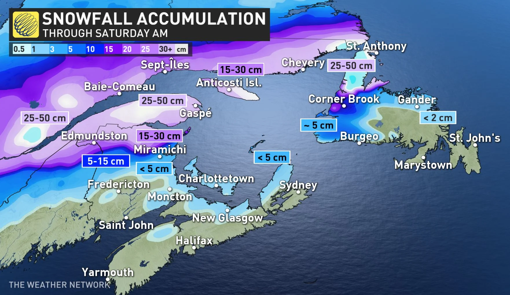
Meanwhile, southern Labrador can expect more snow than rain with this system. Storm totals of 30-50 cm could fall near the Strait of Belle Isle, tapering off the further it moves north.
Beyond the system, temperatures will be near seasonal for the weekend as the system departs the region. It will then turn much milder for a few days next week.
For more details on the impacts and timing of this complex storm, watch the video that leads this article.
Check back for the latest on conditions across Atlantic Canada.