Flood and wind threat in B.C. with incoming pineapple express
Flooding concerns are heightened again in B.C. as a new atmospheric river will bring additional, abundant amounts of rainfall, as well as blustery wind gusts that could disrupt power and travel, into this week
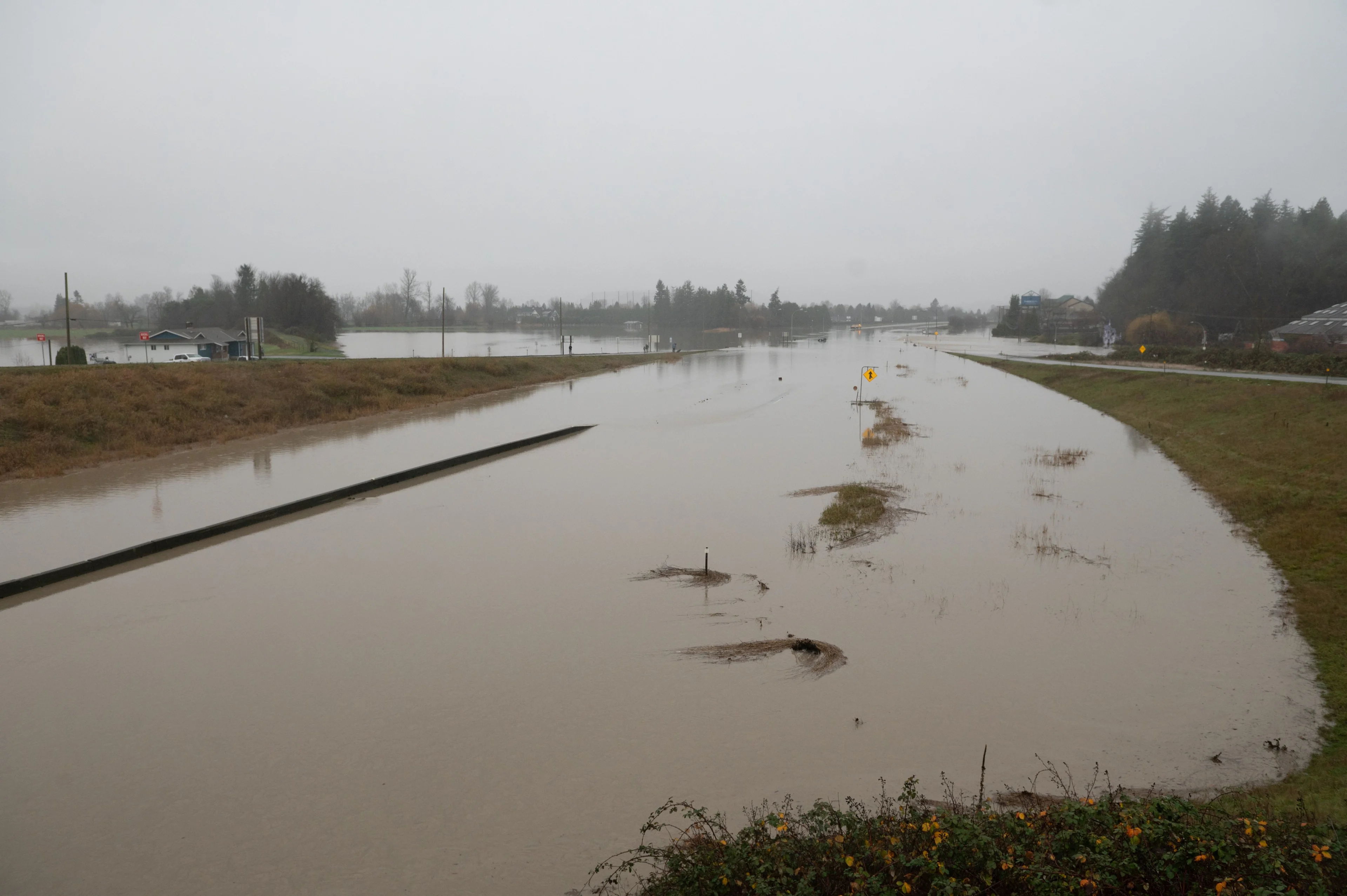
Areas in B.C. that experienced flooding issues by this past week’s precipitation will see more heavy rainfall with an incoming atmospheric river, potentially worsening the situation once more with additional washouts and landslides, as well as a landslide risk.
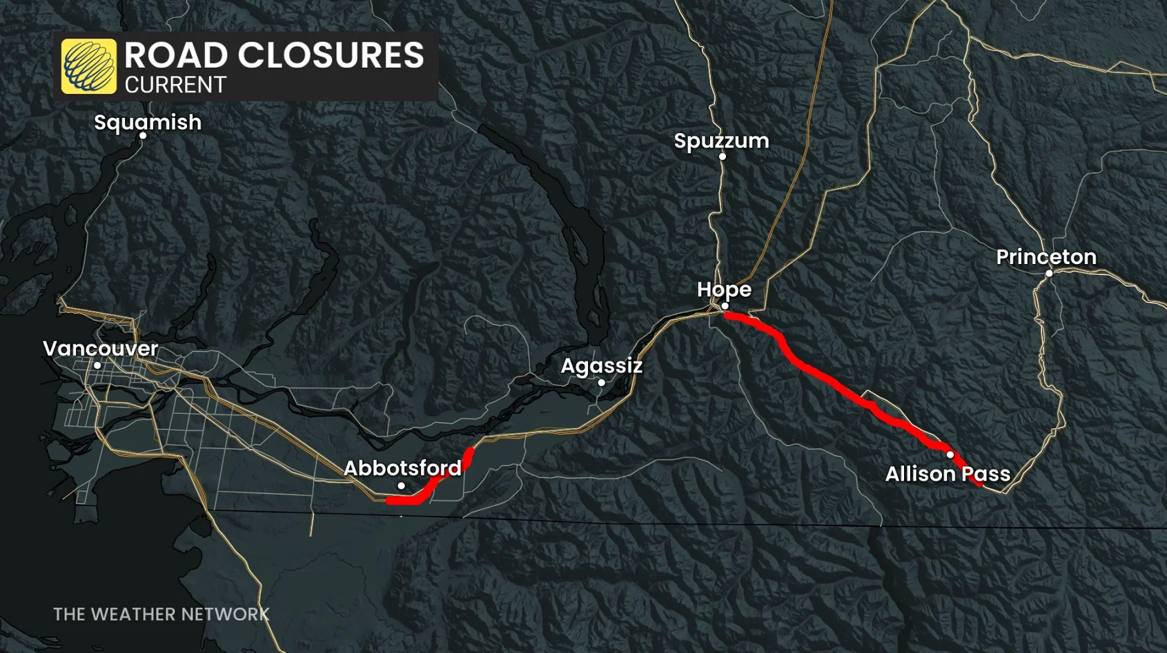
Rainfall warnings are in place for parts of the province. Water will likely pool on roads and in low-lying areas. Don't drive through flooded roadways. Allow extra time for travel. Watch for washouts near rivers, creeks and culvert
DON'T MISS: What’s a Pineapple Express? Diving into this robust atmospheric river
There could be additional road closures, along with possible ferry and flight delays, and cancellations, due to potent wind gusts through Monday.
Here’s a look at how this weekend’s atmospheric river differs from the one that hit just a few days ago.
B.C.’s forecast holds additional hefty rainfall totals

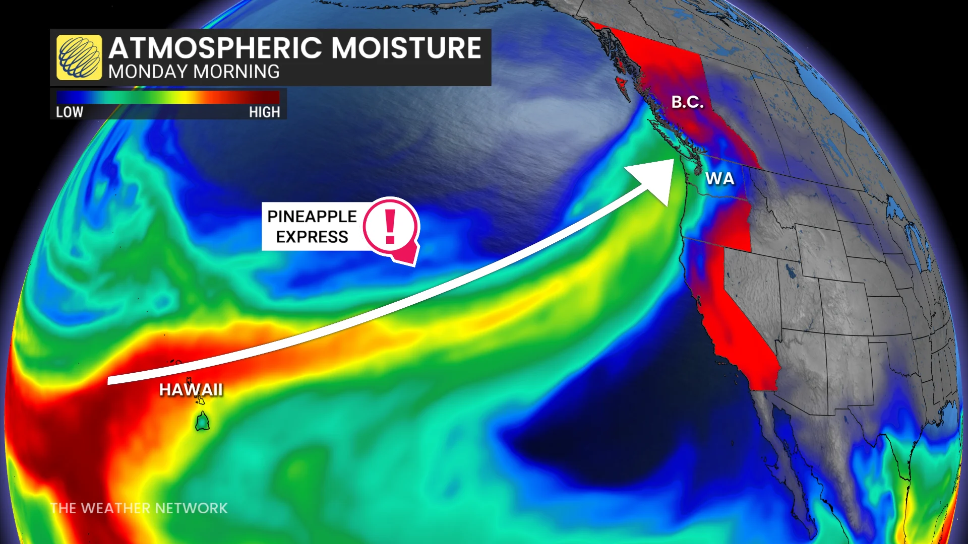
The heaviest rainfall will arrive late Sunday into early Tuesday as a fresh atmospheric river arrives on the West Coast. Expected to impact as a Category 4 or AR-4, this type of atmospheric river is known as a pineapple express because it transports a rich reserve of moisture straight from the tropics into the West Coast.

The pineapple express tends to produce higher freezing levels than typical atmospheric rivers. Higher rainfall totals are shifting farther north compared to the previous atmospheric river.
Forecasters anticipate that this event will reach an AR-4 on the scale used to measure the intensity and impacts of atmospheric rivers, meaning that the event’s hazardous impacts could outweigh any benefits offered by the additional precipitation.
High-impact weather event with additional flooding is likely. Additional road closures are possible due to washouts, landslides, and water inundation. As well, gusty winds could bring power outages and there are likely to be travel and ferry delays.
Comparing the two atmospheric rivers
Aside from transporting more moisture into the coastline, this latest event will differ from the atmospheric river we experienced this past week.

Dangerous rainfall totals: We can expect an additional 80-100+ mm of rain throughout the Fraser Valley and Coast Mountains through Monday. The highest amounts across lower elevations are forecast for the northeast sections of Metro Vancouver. Locally, 200 mm is possible in the North Shore Mountains and western Vancouver Island.
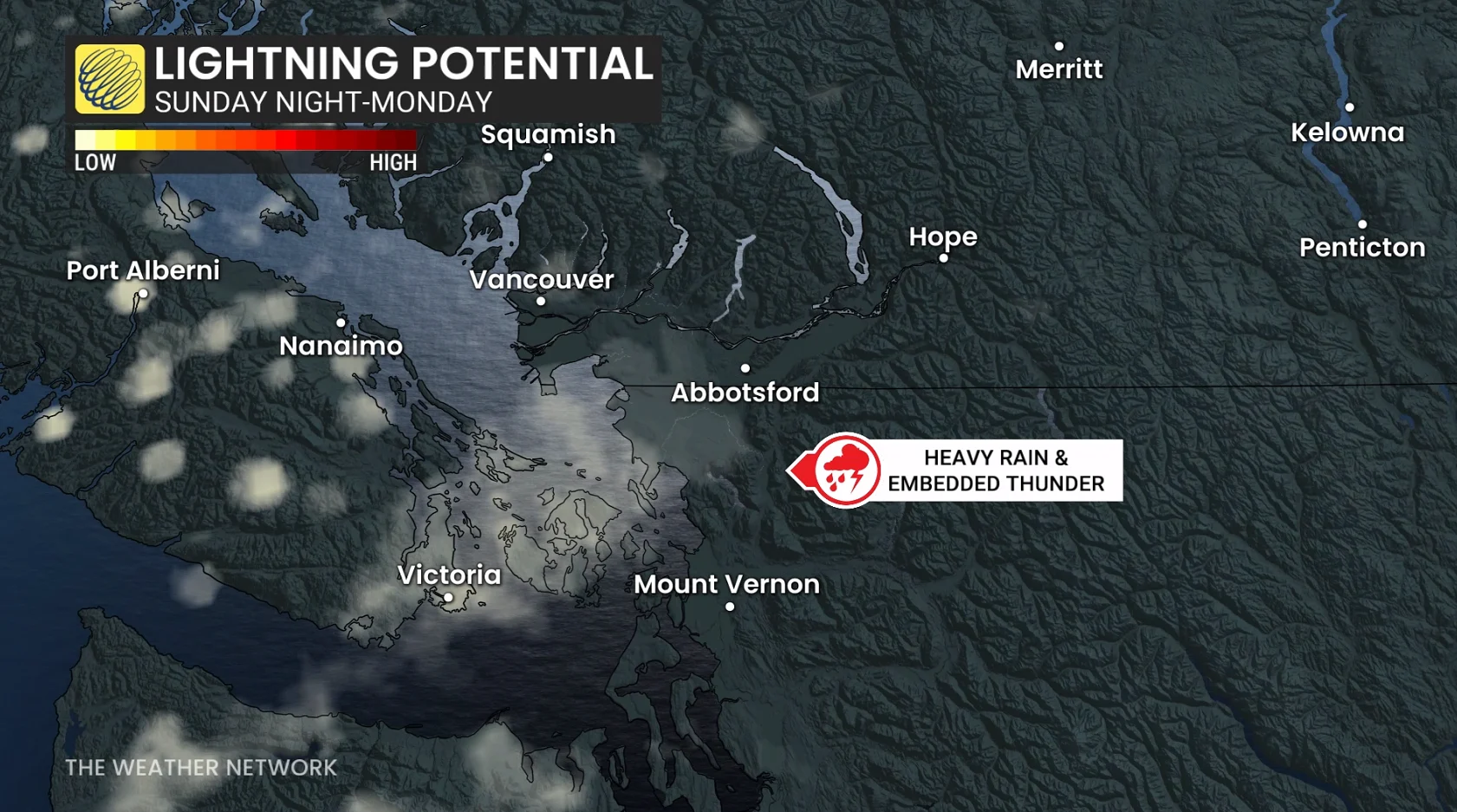
Heaviest rainfall rates are expected from Sunday overnight to the pre-dawn hours on Monday, reaching as high as 10-15 mm an hour.
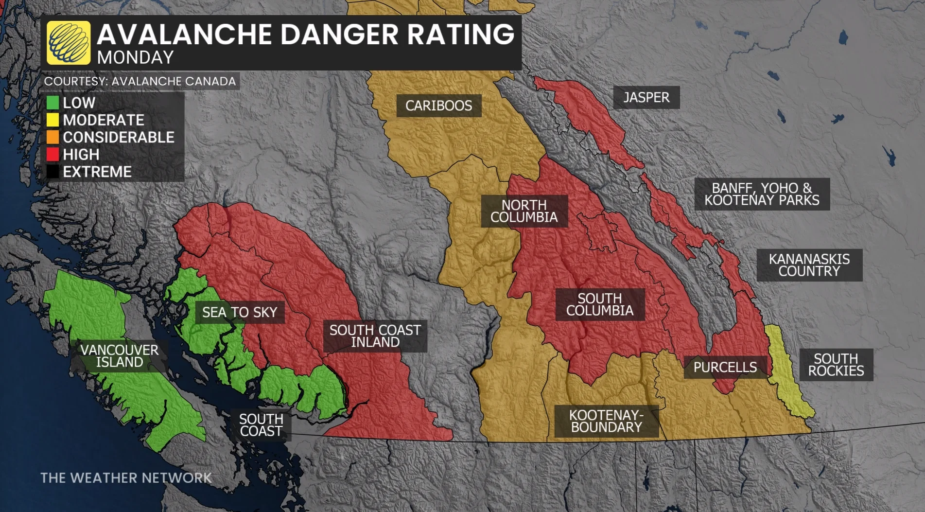
With the second round of moisture on Tuesday, we can expect more rainfall but not as heavy as forecast on Monday. However, cold air aloft will bring heavy snowfall for the alpine region, helping to reduce run-off.

Waterways are already swollen from this week’s rains. This much rain in a short period of time, plus snowmelt, could exacerbate both the flooding and landslide risk in vulnerable areas.
Stronger dynamics: Enhanced lift in the atmosphere could provide an opportunity for thunder within the heaviest rainfall on Sunday night into Monday. Don’t be surprised if you hear some rumbles across southern Vancouver Island and the Lower Mainland after heading to bed.
Rivers and streams are already running high and the ground is saturated, increasing the risk of flooding with those conditions in place.
Damaging wind threat: Unlike last week’s event, strong wind gusts are in the forecast this weekend.
A deeper low is across northwestern B.C., increasing wind speeds as the low approaches Haida Gwaii Sunday evening. Southeasterly gales develop in the Georgia Strait and offshore Greater Victoria Sunday night, increasing the power outage threat for exposed coastal sections and the Gulf Islands. soils are saturated, increasing the risk of falling trees.

As the cold front slowly slides down the coast and the low lifts north of the region, strong winds continue and push inland towards the Fraser Valley through Monday afternoon and evening, becoming southwesterly up to 90 km/h.
Strong, southwesterly winds up to 80 km/h are forecast for Greater Victoria through Monday afternoon, increasing the threat of wind-related impacts.
And as the low lifts into Alberta, damaging winds are possible through the southern Interior, as well, with gusts up to 80 km/h possible.
Higher freezing levels: Coastal mountains will be higher than 2500 m, locally more than 3000 metres. High alpine snowmelt and instability are certain.
Temperatures at sea level will approach 15°C on Monday afternoon for Victoria and the Lower Mainland.
With the high freezing level 2000 m to 2500 m and a warm air mass, snowmelt is expected. Combined with the rainfall, landslides and mudslides can occur through Monday.
Stay with The Weather Network for all the latest on conditions across B.C.
Thumbnail courtesy of Abbotsford Police Department/@AbbyPoliceDept/X.