
Flash freeze for Nova Scotia as temperatures fall Saturday night
Expect icy surfaces across Nova Scotia for the remainder of the weekend as temperatures plummet behind Saturday’s heavy raining behind the rainfall
A bout of heavy rain that soaked Nova Scotia on Saturday aided mild temperatures in melting the prolific snowbanks that still surround communities across the province.
A rapid temperature drop behind the departing system will lead to a flash freeze across much of Nova Scotia. Any wet surfaces like steps, sidewalks, driveways, parking lots, and roads will quickly become icy into Saturday night.
Use extreme caution if you have to go outside—even if it’s just to take out the trash or grab the paper.
DON’T MISS: Earth just experienced its hottest 12 months in recorded history

A system moving across Atlantic Canada to start the weekend brought widespread heavy rain to Nova Scotia through much of Saturday. We saw rainfall totals of 20-40 mm across the province, with higher totals around the Halifax area.
The combination of runoff from heavy rain and towering snowbanks throughout the province led to plenty of standing water on roads, sidewalks, and parking lots during the day Saturday.
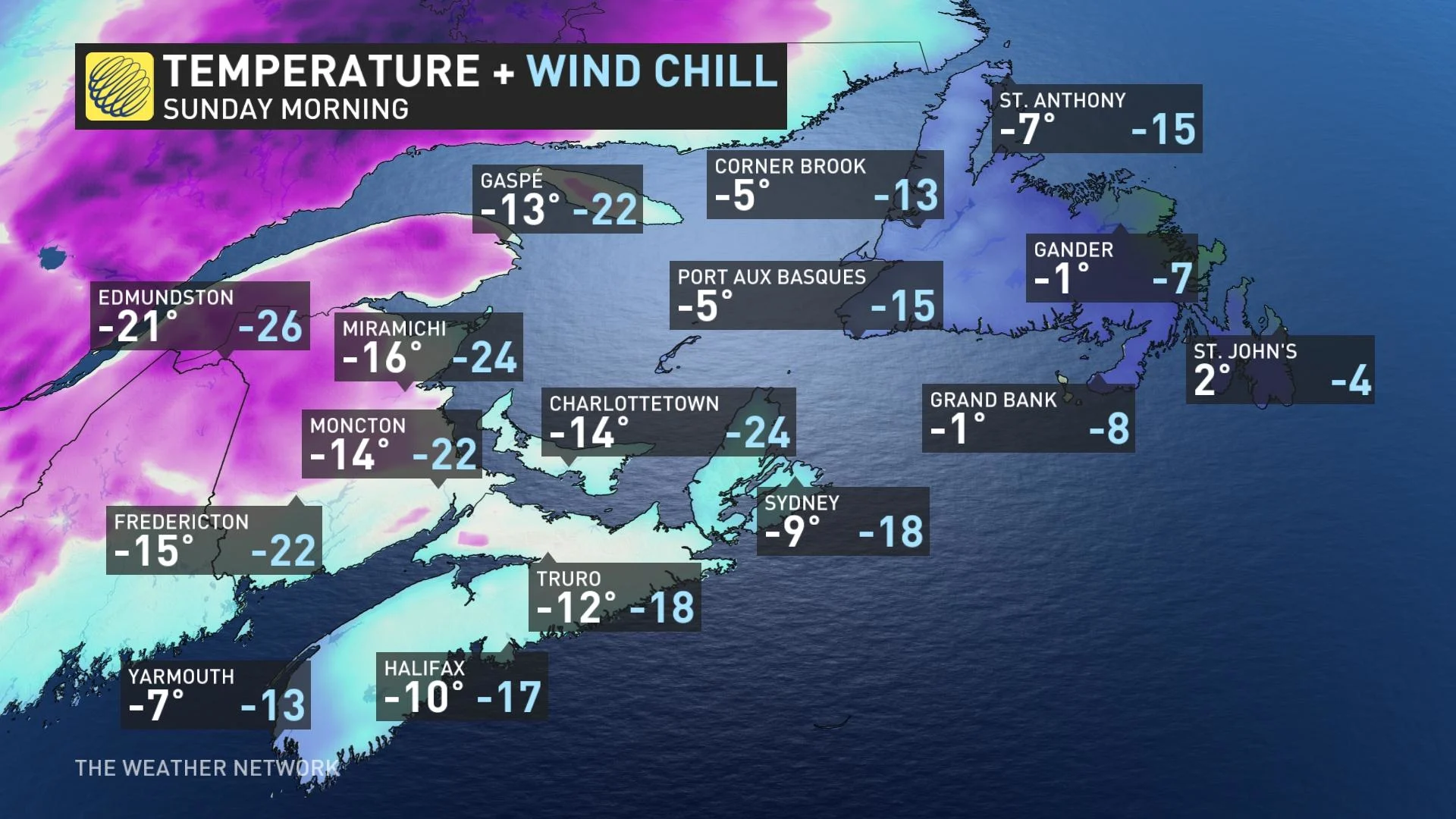
Temperatures began to plummet behind the departing system late Saturday afternoon, and many communities will bottom-out around minus 10 degrees by Sunday morning.
MUST SEE: Atlantic ‘hurricane alley’ sees ominous mid-July heat in February
A sudden lurch from rain to a hard freeze will lead to a flash freeze across much of Nova Scotia through the overnight hours Saturday into Sunday.
Environment and Climate Change Canada (ECCC) issued a flash freeze warning for much of the province.
“Flash freeze warnings are issued when a rapid drop in temperature is expected, that can cause water from rain or melted snow on streets and sidewalks to quickly freeze,” ECCC said in its warning.
Expect a crust of ice to develop on wet surfaces like steps, driveways, sidewalks, parking lots and roads. Take extra care heading outside over the next 24-48 hours. These conditions are primed for folks to slip on unseen ice. Black ice is very likely on untreated side roads.
Temperatures will remain around or below freezing through Sunday and into Monday, which could keep icy surfaces slick for an extended period of time.
Stay with The Weather Network for the latest on your forecast across Atlantic Canada.