El Niño is here for the summer—but how strong will it grow?

Forecasters see a decent chance that El Niño will grow stronger in the weeks and months ahead, affecting weather patterns from Australia to Newfoundland
El Niño conditions are here at last—and there are signs that this event could intensify as we dive deeper into the summer months.
Warmer waters in one section of a vast ocean may not seem like much, but this patch of unusually steamy temperatures in the Pacific Ocean exerts a vast influence on global weather patterns that could affect your summertime weather here in Canada.
RELATED: WHO prepares for El Niño-linked spread of viral disease
El Niño rapidly develops after a lengthy La Niña
Featuring a monthslong pattern of above-normal water temperatures in the eastern Pacific Ocean, an El Niño event can have far-reaching consequences that range from suppressing hurricane activity in the Atlantic to the number of days this summer you’ll want to head outdoors or lurch for air conditioning.

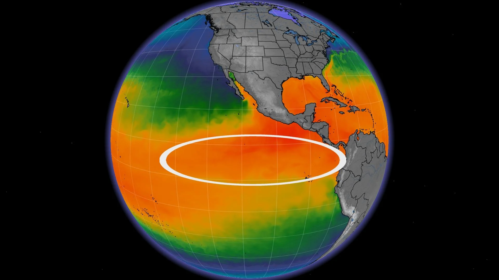
Sea surface temperatures in the eastern Pacific Ocean around the equator are more than 1.0°C above normal for this time of year, a warming trend that’s been persistent for the past couple of months.
This is a swift reversal from the colder-than-normal sea surface temperatures that have dominated this part of the ocean for the past several years. This erstwhile pattern, called La Niña, also had a noticeable impact on the world’s weather patterns.
Odds of a strong El Niño are on the rise
Given the rapid rate of warming in this section of the Pacific and its apparent staying power, forecasters with the U.S. Climate Prediction Center (CPC) expect with near-certainty that El Niño will stick around through at least early 2024.

The U.S. Climate Prediction Center's forecast shows greater than 90 percent odds of El Niño sticking around through at least early 2024. (NOAA/CPC)
It’s not shaping up to be a marginal event, either. Forecasters see an 84 percent chance of this turning into “at least” a moderate El Niño or stronger, and better-than-even odds of a strong El Niño developing by the fall or winter months.
Data collected by NOAA found that it’s not just surface temperatures measuring above normal. Subsurface ocean temperatures, stretching down to about 300 m below the surface, are also coming in more than 1.0°C above normal in recent weeks.
This reserve of warmer waters boosts forecasters’ confidence that a strong El Niño could develop this year, reinforcing its effects on seasonal conditions across Canada and around the entire Pacific basin.
WATCH: How El Niño could impact any major storms coming to Canada
What this may mean for your summer plans
While each event is different, experts can look at past El Niño summers for clues about what kind of overall conditions we might expect in the warmer months ahead.
Between past El Niño seasons and long-term model guidance, current predictions show a mixed bag for Canada in the months ahead.
“While we will see periods of hot and dry weather, the heat will be broken up at times by shots of cooler weather,” Dr. Doug Gillham wrote in The Weather Network’s official summer forecast.

Gillham added: “Overall, a cooler summer is expected compared to the past few summers, especially across the eastern half of Canada. However, we will still see some lingering effects from La Niña with periods of hot weather, especially across western Canada.”
LEARN MORE: Why does your long-range forecast change so often?
This year’s strengthening El Niño could also have significant ramifications for folks in the eastern half of the country during hurricane season.
A typical El Niño summer would experience increased wind shear blowing east over the Atlantic Ocean, shredding apart any disturbances that attempt to grow into tropical storms or hurricanes.
However, sea surface temperatures across almost the entire North Atlantic Ocean are incredibly warm compared to normal, which may offset El Niño’s typical suppressive effects on the basin’s hurricane season.
From thousands of kilometres away, a pattern’s ripples reach your doorstep
An El Niño event occurs when sea surface temperatures around the equator in the eastern Pacific Ocean come in 0.5°C warmer than normal for roughly seven consecutive months. That may seem a bit arbitrary and academic, but it’s a large enough temperature anomaly over a long enough period of time to affect weather patterns around the world.
During normal conditions, prevailing winds blow west from South America toward Oceania. These persistent winds keep warmer water pooled up near Australia while drawing cold water from deep in the ocean up to the surface off South America.

MUST SEE: Surprise! This year’s hurricane season started with a storm in January
That wind pattern occasionally breaks down or even reverses direction, allowing that warmer water near Australia to migrate east toward South America, significantly raising ocean temperatures in the eastern Pacific.
El Niño events that result from this breakdown typically last about a year or less, but some events, such as one in the mid-1980s, have stuck around for longer than a year and a half.
This article contains files from Dr. Doug Gillham, a senior meteorologist at The Weather Network.