
Dreaming of a White Thanksgiving, Ontario? Polar vortex drives snow risk
From record July-like heat to freezing temperatures with the risk for snow -- this Thanksgiving long weekend will bring quite the change to Ontario
Abnormally warm temperatures have set new October records across parts of Ontario, with days of high heat and barely any rain in sight. That's thanks to a large ridge of high pressure situated over the Great Lakes region, something that's about to break down.
In fact, a sliver of the polar vortex trapped in a deep trough will drive that change, with snowfall potential for some, rain for others, along with temperatures 5-10 degrees below normal as we head into the Thanksgiving long weekend.

DON'T MISS: Polar vortex to replace Canadian heat with chill, snow
The cooling temperatures will be more typical of early November for Sunday and Monday, as many places will stay in the single digits.
Major weather changes for Thanksgiving long weekend
Areas: Southern and northeastern Ontario
Timing: Thursday afternoon through the long weekend
Weather: Wet snow and possibly even a slushy coating of snow is forecast for parts of Ontario this Thanksgiving, as we plunge from record breaking July-like heat, to feeling like November in just a matter of days.
We'll see the first signs of change on Thursday as a weak front moves in showers to northeastern Ontario through the day, and southern Ontario through the night. Friday morning's commute in the Greater Toronto Area (GTA) is likely a wet one as a stronger, cooler system takes over. Rain could linger over Toronto, with 20-30+ mm possible, which is more rain than we've recorded all of last month. While the south is likely to see a break from the consistent rain as it heads east into Ottawa through Friday, it won't rest for those to the north.
Visit our Complete Guide to Fall 2023 for an in-depth look at the Fall Forecast, tips to plan for it and much more!
You'll all notice the winds, coming from the northwest, and bringing in a chill province-wide.
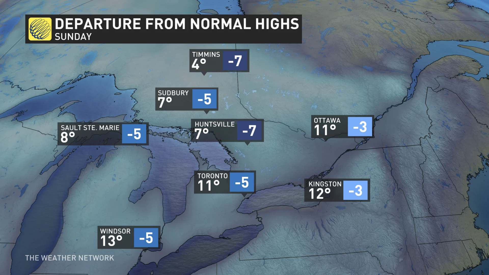
By Sunday into Monday, temperatures will fail to reach the freezing mark across the northeast, converting lingering rainfall into a rain/snow mix over Sudbury to Kapuskasing and the higher elevations of Algonquin.
While exact accumulations are uncertain, we can expect a slushy coasting of the white stuff waking up on Thanksgiving.

Find out what the rest of October has to offer in our October outlook.