December weather becoming less of a wild card for winter in Canada

Our early winter pattern is becoming less foggy and that's due in part to the tropical systems this fall
Our preliminary winter forecast highlighted December as the biggest wild card in the winter forecast. While we will not have our final answer to this question until we release our Winter Forecast on November 19th, there are more clues now as to how December could unfold, thanks in part to all of the hurricanes and tropical storms that we have seen recently in the north Atlantic.
Visit our Complete Guide to Fall 2019 for an in depth look at the Fall Forecast, tips to plan for it and a sneak peek at the winter ahead
Before we take a closer look at the December pattern, here is a quick overview of what we will see before December.
We still expect that much of Canada will see a false start to winter – a period of wintry weather well before the winter pattern sets in. We have already seen shots of wintry weather across the Prairies, and during late October and early November we expect that the focus of the chilly weather will shift east into the Great Lakes with the first lake effect flakes flying before Halloween. However, we do not expect that we will lock into our winter pattern until January.
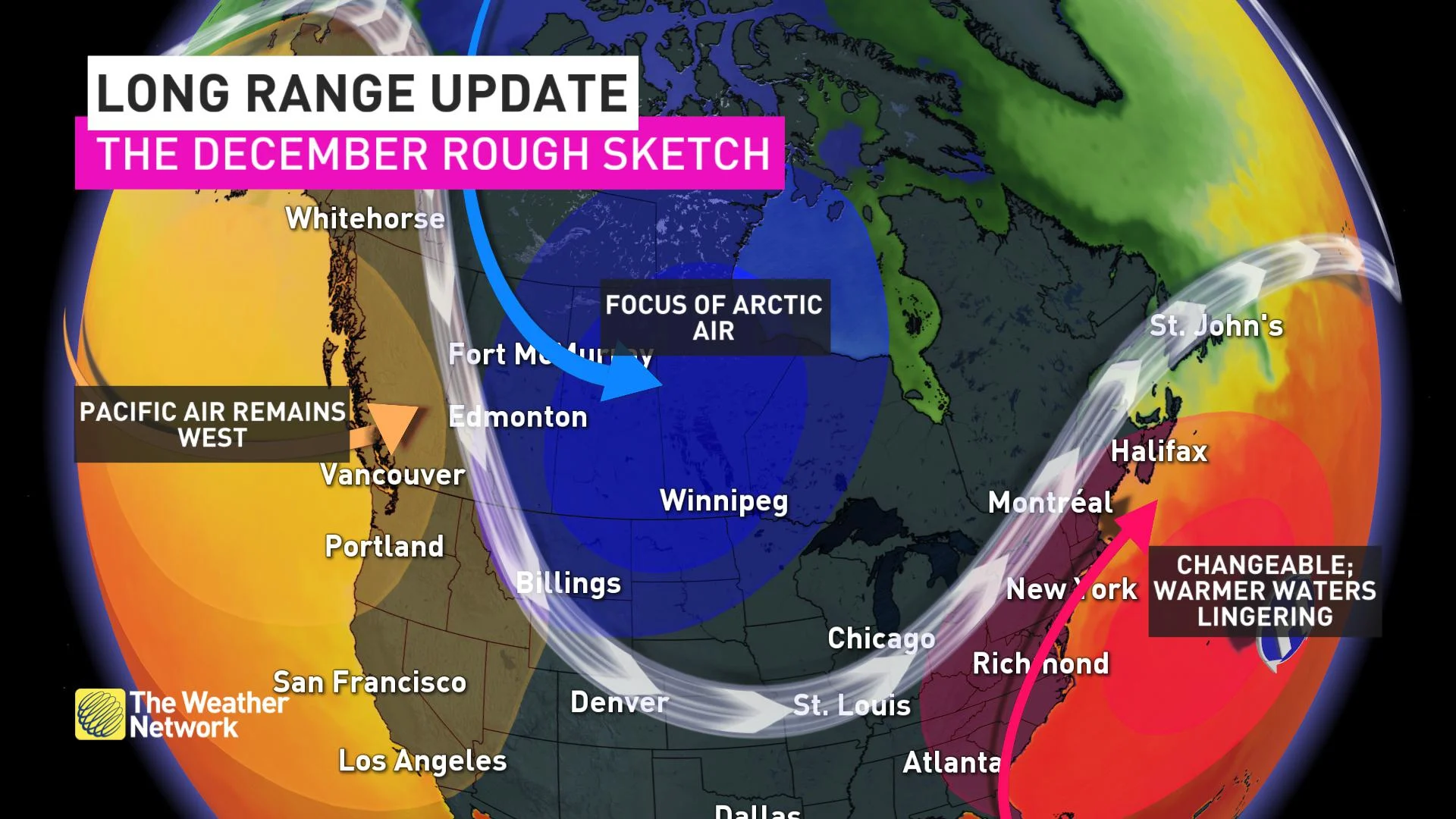
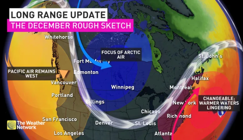
During December we expect that winter will lack commitment, especially from the Great Lakes to Atlantic Canada. However, the question is whether we will see a widespread mild pattern like we did last year or will there be enough cold air around to resist the mild pattern? This would result in a more active and messy pattern.
One of the key contributors to the anticipated milder December pattern is the warmer than normal ocean water temperatures in the western Atlantic. Similar to what we saw last year, this warm water strengthens the Bermuda High over the western Atlantic and should help to bring a southwesterly flow of milder air into the region and reduce the potential for Arctic air into areas from the Great Lakes to Atlantic Canada.
The map below shows the sea surface temperatures anomalies at the end of August. The various shades of orange and red off of the east coast of Canada and the United States highlight the widespread warmer than normal ocean water temperatures.
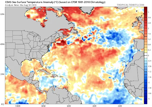
However, we have seen some significant changes in the sea surface temperature pattern since the end of summer. The map below shows the current sea surface temperature anomalies.
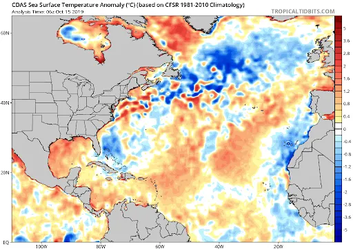
While a large part of the Atlantic is still warmer than normal, the warm water is not nearly as widespread as it was at the end of August and we now have several areas of colder than normal ocean water temperatures. Much of this change is due to the hurricanes and tropical storms that have tracked through this region during the past six weeks.
This loss of heat from the North Atlantic will prevent the Bermuda high from being as strong as it would otherwise have been, and this reduces the potential for a repeat of what we saw last December when temperatures were so mild.
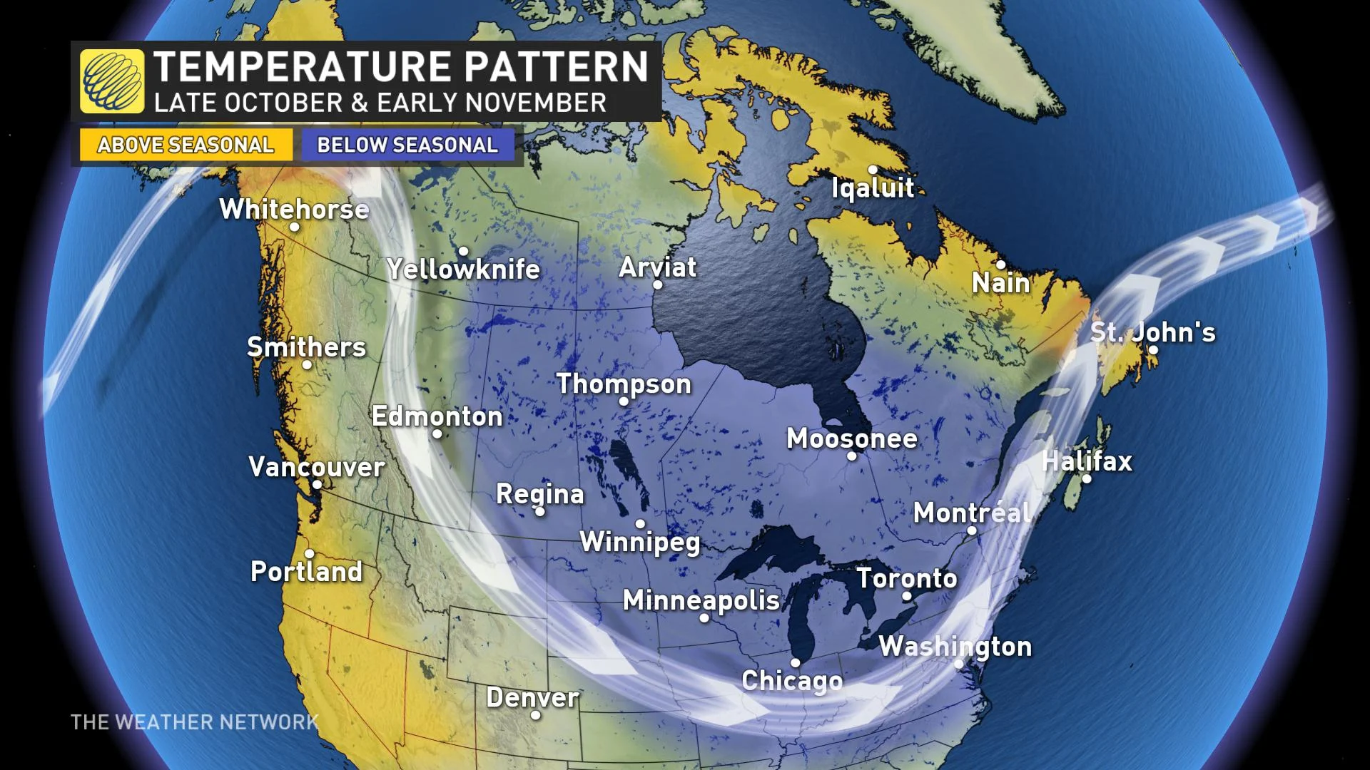
In addition, we are in a pattern that continues to deliver unusually chilly shots of Arctic air into central Canada. The map below shows temperature anomalies so far during the month of October.
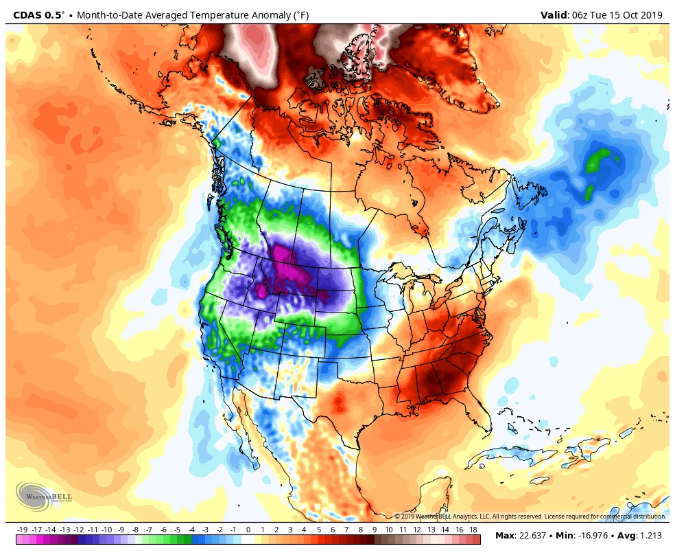
This highlights the exceptionally frigid weather that has dominated across most of B.C. and the Prairies. Parts of southern Alberta have been more than 15 degrees colder than normal during the first two weeks of October.
While it is possible that this pattern will break down for a while in December, we do not currently see any indications that mild Pacific air will take over and dominate the country.
So, what does this all mean for December? It looks increasingly unlikely that a mild pattern will dominate much of Canada. The focus of the coldest weather is expected to be across the Prairies, but this arctic air should fight back at times against the milder pattern to the south and east.
Therefore, from Ontario to Newfoundland we expect a more changeable pattern. It is unlikely that we will lock into a frigid pattern, but this pattern could still deliver some high impact winter weather well before we lock into our mid-winter pattern.